Several of you have been asking about this, so let’s have a look.
Essentially this is the proposal from the CamBedRailRoad campaign which opposes the southern route into Cambridge in favour of a northern route. And inevitably there were those that preferred what ministers have now chosen is their preferred option – the southern route – not least because of noise & pollution issues.
“Can’t we have an integrated public transport system?”
The point Huw Jones – former Labour MP-candidate for South East Cambridgeshire in 2015 and 2017, makes is a sound one: the northern villages don’t gain any direct benefit from East-West-Rail (however powered) passing by their villages. Furthermore, a cycleway alongside doubling up as an access road for repairs doesn’t really cut the mustard for what are all growing villages.
Hence back in March 2022 I played with the idea of having a light rail / Tram-train route alongside the East-West-Rail corridor that would serve the villages concerned – noting Waterbeach Newtown will become a town in its own right given the existing local plan proposals

Above – from my post in March 2022
You can see a much more detailed and technical analysis here on the northern approach
Of course if built it would be far more smooth, and also support the case of re-opening the Cambridge – Haverhill line and re-linking the latter town up to Sudbury again, which opens up the following:
- An alternative route to Colchester and Ipswich (which means increased resilience when the existing line goes down as it periodically does)
- Onward services (subject to additional chords being built at existing rail junctions) to Chelmsford (ARU’s other main campus) and Southend (Seaside resort).
- An alternative route to London Liverpool Street from Cambridge – again increasing resilience in the network as and when the existing line goes down
Hence for me one of the criteria that should be included in all of the proposals is strengthening resilience in the network as and when a line goes down.
“Would it do away with a C2C busway?”
Potentially – there’d be no need for the controversial part of the busway (ie over Coton Orchard to Grange Road) to be built because anyone wanting to go beyond the West Campus would go by train and get off at any of Cambridge’s railway stations. Why bother being stuck in traffic?
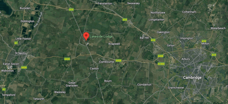
A light rail making use of the East East Rail Corridor could also diverge between Cambourne and St Neots to serve the old Papworth Hospital site and the industrial estate at Papworth Everard (Where I’ve highlighted Lakeside Lodge on G-Maps here)
The main East-West-Rail line simply follows the A428 road corridor, with the light rail providing the flexibility for Papworth Everard and the villages north of Cambridge that the heavy rail route would otherwise not serve. At least that way the residents of the villages get a high quality rail-based transport service. Furthermore, the record of trams and light rail is impressive.
“They have a proven record in attracting people out of cars; the rate of modal transfer from car to tram at peak times is typically around 27%. This compares with estimates of between 4% and 6.5% for quality bus investment. Levels of traffic reduction from trams are typically around six times greater than with bus schemes.”
“Manchester Metrolink registered a modal switch approaching 32%. Light-rail can move large passenger flows more cost-effectively than buses at a fraction of the cost of a full urban railway“
Decarbonised Transport Report March 2021 by Smart Growth UK, p13.
Cambridge’s westward links
Back in the olden days, Cambridge had a number of westward rail links. One out to Huntingdon, one out to Sandy, and one out to Hitchin. And technically Peterborough in the North West. As I mentioned in my last-but-one blogpost, not everything needs to be in Cambridge. Furthermore, there are a number of towns and cities geographically closer to Cambridge than say London which may benefit from direct services. Rail Future East explored some of these in their December 2014 newsletter here.
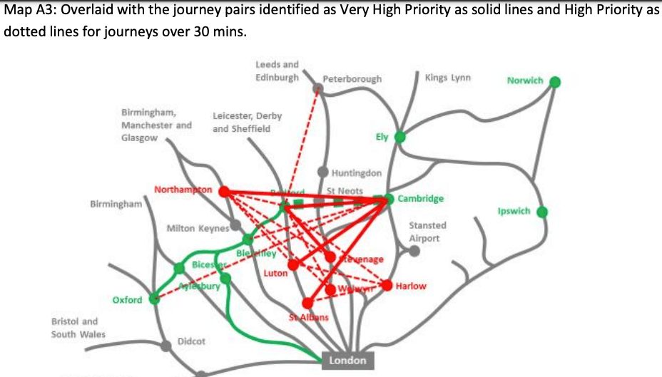
Above – Rail Future East Dec 2014, p23
Northampton, Luton, Bedford? All seems fine in principle. When we look at it through the prism of the existing network, you can see that a rail link from Hitchin to Luton (under 15 miles as the dragon flies) should be a straight-forward link up.

Above – p24 from Rail Future
Furthermore, there is (again in principle) the possibility of re-opening the line between Bletchley and Luton.
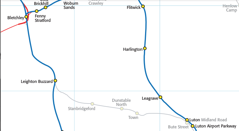
Above – from the New Adlestrop Atlas again
That potentially is a cheaper way to get services from Northampton (and any of the towns and cities north of it – such as Rugby, Coventry, and even Birmingham) as an alternative cross-country service. Again it increases the resilience in the network as it potentially provides an alternative route from Cambridge to Birmingham when the existing Cross-Country route via Peterborough goes down – as it regularly does! Furthermore, the restoration of the Bletchley Chord adds to the resilience of the network by providing an alternative route to Oxford from Cambridge.
Don’t forget the technical report for East West Rail!
“I do not have time to read 250 pages of complicated stuff!”
Above – the technical report – all 250 pages of it
The bits that jumped out at me other than the maps were the contents about Cambridge and the Cambridge Area Assessment in the final appendix.
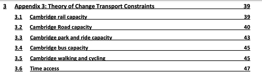
Above – you can browse through the above at your leisure.
Above – from p232 by ARUP
The biggest barrier to re-linking Oxford and Cambridge by rail? Cheese!
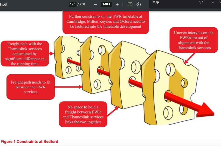
You’ve gotta get through all that cheese on p196!
Actually, it’s more serious than that.
They covered things that need proper archiving, fact-checking, and referencing so they can be easily referred to again.
Such as Cambridge’s existing park and ride capacity. How does it compare with projections of economic (and science park) growth?

Above – from the Technical Report p43
How quickly will these fill up? Note we are ***currently in economic downtimes*** – all it needs is an upturn (easier said than done) and suddenly we may find ourselves at capacity.

Above – same page.
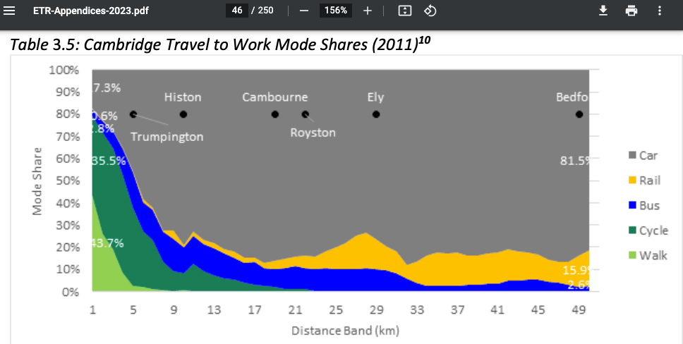
There then follows an interesting chart on transport modal share for commuters – note this is from 2011 so won’t account for a fully up-and-running guided busway or cycleway
Now lets look at railway stations
This map on p49 is particularly interesting. MSOA I think means “Middle Super Output Area” – and are broken down as such here in Cambridgeshire.

What the above diagram tells us is:
- In the shaded bits, what percentage of commuters commute to Cambridge by rail.
- In the orange circles, the rail journey time
What it also tells us further down is how the spread of commuters is restricted by uneven rail network coverage.
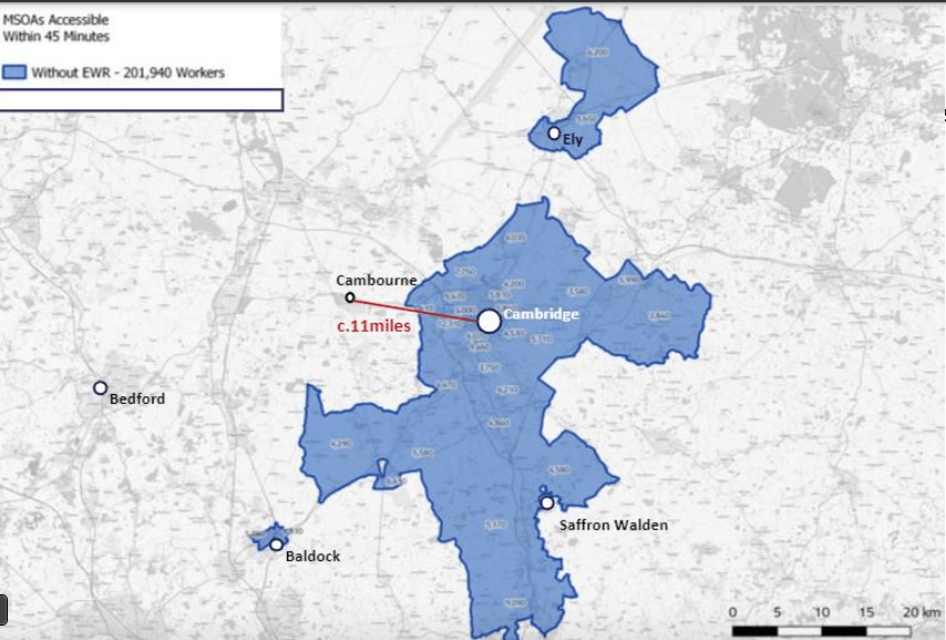
Above – EWR Report p50
Build East West Rail with stops at Bedford, St Neots and Cambourne, and things change.

Above – EWR Report p50
What the above ***does not mean*** is that everyone living in Bedford & St Neots is going to resign from their existing jobs and commute to Cambridge. Furthermore it doesn’t mean that everyone trying to get a house in order to work in Cambridge will suddenly move to Bedford and St Neots. In fact, they’ve modelled for a variety of scenarios based on existing planning development.

Above – EWR Report p59
So the transformational scenario for Bedford-Cambridge rail services will be over 1,300 commuters. What’s harder to estimate is:
- People employed in Bedford who resign to take up new, higher paid jobs in Cambridge
- Existing car commuters living in Bedford who drive to Cambridge
- People who move to Bedford to take up a new job in Cambridge because of things like high house prices
“How do we avoid the risk of Cambridge becoming this economic vortex sucking in all of the skilled workers from around the area? Do other towns risk becoming dormitory towns?”
Only if ministers choose to let the market rip and do its worst. Which could happen given the current party in power! Only it will be by their incompetence rather than by design. The challenge for the next government (as building this phase will take almost a decade) is to have an industrial strategy that encourages some firms to establish themselves at or near the transport interchanges. That way you don’t end up with dormitory towers stuck out on the other side of the green belt shuttling people into and out of the science parks.
Which reminds me – the green belt is going to become an election issue because of the housing crisis. The briefing here on what is and isn’t green belt may interest some of you. In particular the history of it, the context of the times, and other laws and forms of protection that can be used to protect the countryside from the risk of urban sprawl. Something that coincides with the House of Lords Land Use Commission Report here
Food for thought?
If you are interested in the longer term future of Cambridge, and on what happens at the local democracy meetings where decisions are made, feel free to:
- Follow me on Twitter
- Like my Facebook page
- Consider a small donation to help fund my continued research and reporting on local democracy in and around Cambridge.
