
I was reminded of this in a social media stream but had not explored the data until now.
Note there are inevitably some quirks and bugs – such as routing the Cambridge-Kings Cross routes down the Liverpool Street route to London, but the scale of Cambridge-London rail journeys amongst other things makes for interesting consideration.
Via Will Deakin, you can browse through almost every station in the country using data from the Office of Rail & Road
There’s also a comparison with the Beeching cuts data too
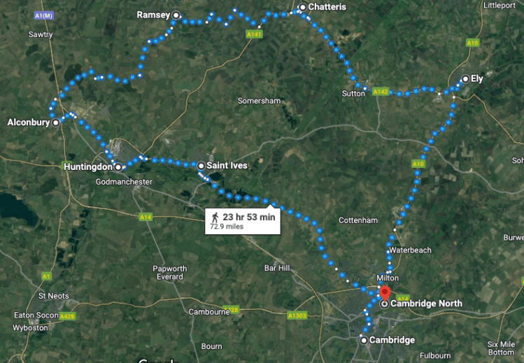
“Where do Cambridge people like to go?”
London – and you can see the quirk in the system that assumes everyone goes down the Liverpool Street line when (in my experience at least with commuting) most people go via King’s Cross – which means heading up towards Stevenage, then swinging around to the right at Hitchin and onto Cambridge.
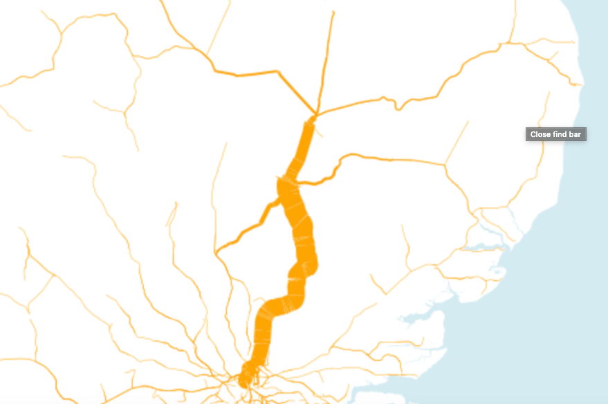
Above – A detail from where travellers from Cambridge railway station went to, and by volume in 2021-22
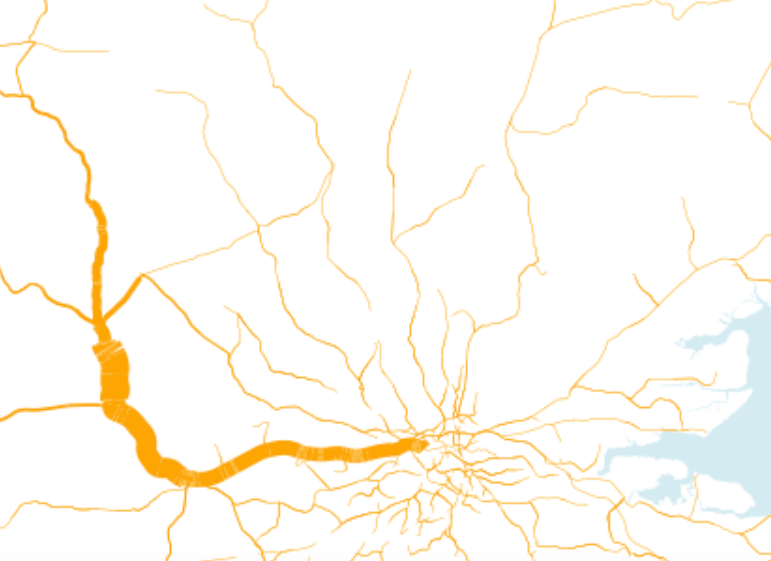
There’s some interesting comparisons between Ely station (East Cambs) and March (Fenland) – the latter slowing to a trickle in comparison. Multiple trains pass through Ely en route to Cambridge, whereas from March it’s just the cross country route if I recall correctly.
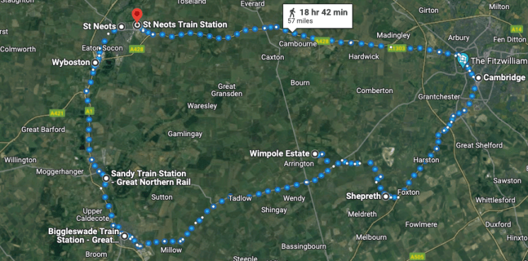
Oxford to Cambridge
The map looks like the diagram below – again the bug cutting off the line that most passengers would use via Kings Cross because the trains are faster, have more direct trains/fewer stops, and have fewer underground stops to pass through.
It also reflects the assessment of the Oxford-Cambridge Expressway Strategic Study
“The lack of east-west rail and road connectivity results in strategic movements (including freight from the south and eastern ports) routing via London (M25 orbital
Oxford-Cambridge Expressway Strategic Study Report Stage 3 (DfT), p12
route) or the Midlands (M5-M42-M6-A14). These strategic movements lead to pressure on these corridors reducing the resilience of the SRN. The lack of eastwest rail connectivity and resultant long and unattractive journey times via London discourage east-west journeys to be made by public transport.”
The other interesting bit is the catchment of 85% of Cambridge’s workforce.
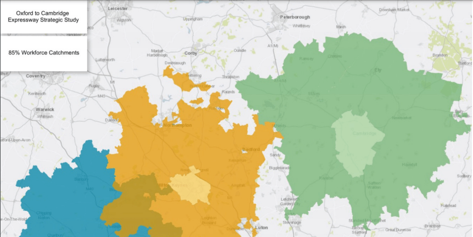
Above – DfT p13
Does that diagram look familiar? It should do.
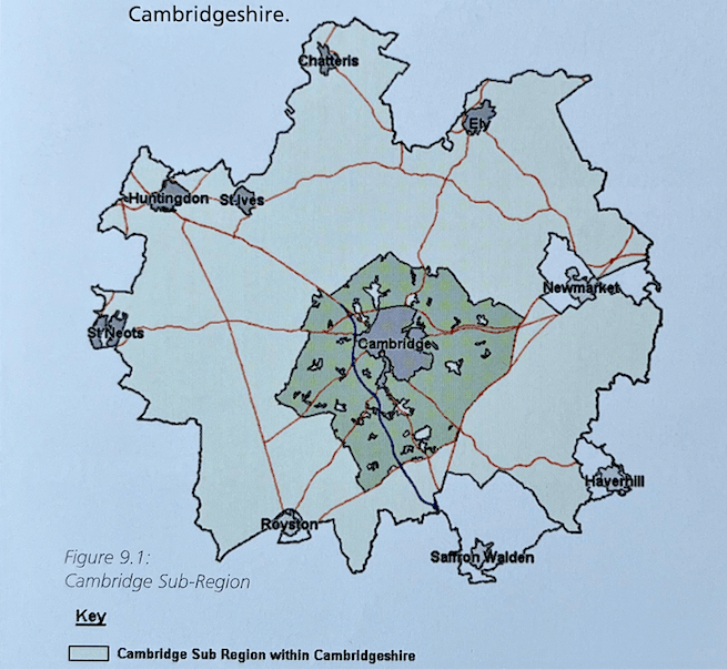
Above – the Cambridge Economic Sub-region 2001


Above – Redcliffe-Maud’s rejected proposals 1969, and Lichfield 1965
“So why hasn’t anyone built a rail or light rail network to link them all up?
Good question.
That’s not to say we cannot start now – at least with the planning. Hence my call for a new generation of suburban/light rail links to build on the proposals from Cambridge Connect, which I blogged about here.
The earlier blogpost makes the case for having that loop sharing the track with other looped lines such as with a Cambourne – St Neots – Huntingdon – Northstowe – Cambridge loop. That effectively would make use of the guided busway (which could be upgraded) and the northerly section of a SW-Cambs loop that serves the currently cut-off villages in that part of the county.
Above – a SW Cambs suburban/light rail loop enabling people to get to Wimpole Hall by rail.
“So whats stopping us?”
Governance structures and highly-restrictive public finance & taxation rules. There isn’t a structure that enables a regional level of government to levy infrastructure taxes on firms and land owners that would benefit the most from such investment.
Everything looks to Westminster for England and that means parliamentary time getting tied up in things that the Scottish Parliament doesn’t really have to be concerned about – such as international issues involving the internal politics of former colonies of the British Empire. Hence why having either a separate English Parliament or some sort of regional devolution that dealt with internal governance only could be one method of sorting out the policy and legislative logjam in London.
And that sort of constitutional reform is A) not for this post and B) for someone else to deal with!
I’ve already made my support for a unitary structure as being promoted by the Cambs Unitaries Campaign. Interestingly it was a debate that Cambridgeshire had in the early 1990s – and actually commissioned lots of expensive work for it (which I’m hoping the councils concerned will allow to be digitised and published).
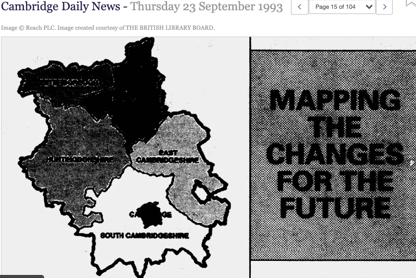
Above – a detail from the old Cambridge Evening News that I featured in Lost Cambridge
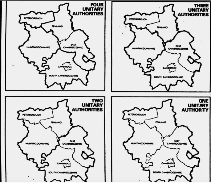
Above – how many unitary councils would you choose?
Noting they kept the options simple based on pre-existing district boundaries. Interestingly, South Cambridgeshire councillors 30 years ago were so opposed to a merger with Cambridge City Council that they suggested merging with East Cambridgeshire to the exclusion of Cambridge City! If *the process* was run again but improved for 21st Century technological, political, and demographic changes, what would the results of surveys of councillors, businesses, and the public show?
And could the results of such work inform not only new local government and regional government structures and boundaries, but also inform new electrified public transport networks?
Food for thought?
If you are interested in the longer term future of Cambridge, and on what happens at the local democracy meetings where decisions are made, feel free to:
- Follow me on Twitter
- Like my Facebook page
- Consider a small donation to help fund my continued research and reporting on local democracy in and around Cambridge.
Below – Cambridge Matters magazine – produced by the city council. You can read online copies here

