Three years after the former Transport Minister Baroness Vere spoke highly of trams, a concept plan by Josh Grantham looks at a Cambridge Orbital. This from a post featured in the Cambridge Independent of 29 Oct 2025
TL/DR? See John Grantham’s article here. If you are convinced and really want trams, join the LRTA and get your copies of Light Rail and Urban Transit magazine!
‘I love a tram – and light rail’ – Said Baroness Vere on Tues 05 July 2022 to the House of Lords Built Environment Committee. Another former Transport minister, Norman Baker of the Liberal Democrats during Dr Julian Huppert’s time as our local MP, wrote a Ten Point Plan for Light Rail, which I featured here.
Feel free to use the above articles in lobbying for trams and light rail!
In my blogpost exploring her comments, I noted that the case for Cambridge Connect Light Rail had changed dramatically – highlighting the crises at Addenbrooke’s, the 2021 census figures for Cambridge and South Cambridgeshire showing significant rises, and the first of what became several big sci-tech applications for development. And that was before Michael Gove and later Matthew Pennycook arrived on the scene.
What also helped make the case for light rail in my view was a diagram in Nathaniel Lichfields study of Cambridge published in 1966 below.

Above-left, Lichfield’s analysis from 1966 in Cost Benefit Analysis in Town Planning A Case Study of Cambridge
“Why are we not linking up the surrounding market towns by either suburban or light rail, and connecting them to Cambridge?”
Ultimately it’s a lack of several things:
- A sound proposal/plan on what to build
- Resources (money)
- Legal powers (in order to enable construction to take place)
- Political willpower (to gather the resources, powers, and support needed to start and complete the project – and overcome opposition)
- Public consent
Assembling all of the above together is not easy. Furthermore, in our political system I don’t think that many of us know what the processes are of someone coming up with a bright idea for new infrastructure and taking it through to the completion of it. With history only being written by the winners (as the saying goes!) we don’t get to hear about the history of failures, why things did not succeed, and what people learnt from it. Unless they used the earlier failures as positive learning in order to succeed in something else later on.
Many of you are familiar with Connect Cambridge (if you’re not, see https://www.cambridge-connect.uk/ ), so I’ll move onto Mr Grantham’s concept
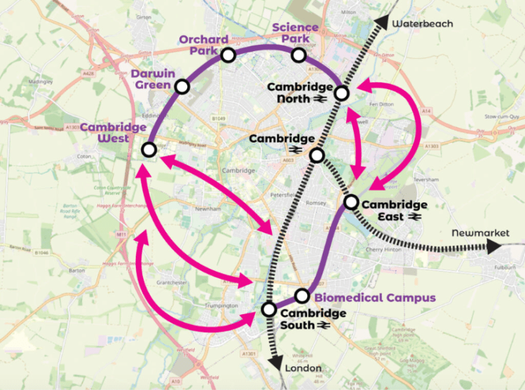
Above – from Josh’s map. In principle it is possible to get from Cambridge North to Cambridge West via existing or soon-to-be-constructed roads/busways/transport corridors
With *a lot of highways engineering* it is also possible to do similar from Cambridge South Station down Fendon Road, Mowbray Road, Perne Road and Brooke’s Road (what William Davidge envisaged in 1934 as the eastern section of the never-completed Cambridge Ring Road).

Above – Davidge’s regional plan for Cambridge p61 – where he also identified areas of green space that should remain undeveloped. (Also, spot the lost railway lines!)
“You mean Josh’s idea is not new?”
Concept-wise, no, but mode of transport, perhaps.
We used to have old horse drawn trams
Hence the Tram Depot pub. And they could have been electrified following this borough council vote in 1904


Above – the proposed extension to the horse-drawn trams in 1899 which ran from the station to the city centre.

The biggest challenges to Josh Grantham’s proposals – and overcoming them
The travel-concept map is as below.
Local history tells us that getting a major transport bridge over Ditton Fields is not going to happen. The smaller discrete nature of the Abbey-Chesterton bridge for the Chisholm Trail meant it sat more easily alongside the existing railway bridge without raising too much opposition. With no spare room at the Fen Road level crossing, you’ll need more than a bridge to connect the Airport site to Cambridge North Station. A new viaduct would be needed – and all previous attempts to build one (mainly for road vehicles) has been blocked by opponents.

Above – Cambs Sustainable Travel Alliance (2025)
Stantec tried to solve the same problem for Marshall’s and their Cambridge East site. And couldn’t.
I went to the Marshall’s consultation a couple of years ago, and noted they had picked up on several of my suggestions in their recent transport submission to the emerging local plan. (See my recent blogpost here)
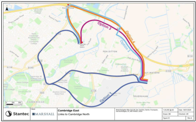
Above – Stantec got tied up in knots trying to figure out a bus route to Cambridge North Station.
My take is that there’s no reason to aim for a link to Cambridge North – desirable as it may be.
“So, what’s the alternative to an Airport/Cambridge North link?
Build a new station on the other side of the A14 to serve a new Cambridge Rowing Lake at Milton – long proposed by the Cambridge Sports Lake Trust.
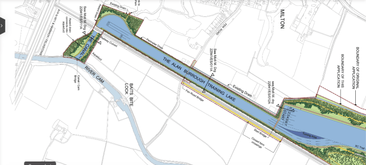

Above – Cambridge Sports Lake proposals for a new rowing lake that would take pressure off of the River Cam, and give the local flora and fauna a break
The result would be a spiral rather than a circle, but it would avoid the need for an expensive solution to Cambridge North. Instead passengers could get off at the Milton Rowing Lakes station and catch a suburban train to Cambridge North.
Furthermore, a station/interchange on the existing Cambridge-King’s Lynn railway line would enable an east-west tram link from the rowing lakes north east of Milton by the River Cam through to Impington and either Northstowe or Girton.
How do you solve the problem of Cambridge South West?
Grantchester and Newnham are so affluent that they don’t need public transport. Apparently.
I jest. Both have been chronically under-provided for in public transport for decades. Which one comes first? The public transport provision, or the reduced car use?
Grantchester Meadows and the flood plains of Bourn Brook and the River Granta/Cam provide huge obstacles for developers wanting to build homes here – not that this has stopped them from submitting big parcels of land at every local plan call for sites announcement.
Linking the long-awaited-for West Cambridge Swimming Pool with Addenbrooke’s Hospital?
That would be my preference of one of Mr Grantham’s bright pink arrows. The time to build a Madingley to Trumpington link was a century ago. One of the options seriously considered by planners was to extend Brooklands Avenue down Chaucer Road and build a new road from Chaucer Road to Barton Road, Newnham. But they built The Fen Causeway by The Leys instead as part of a state job-creation scheme around the time of the General Strike. And even that wasn’t popular at the time in some Conservative quarters.

Above – “The Costly Causeway” in the Cambridge Chronicle, from 15 December 1926 in the Cambridgeshire Collection. The Chronicle was a staunchly Conservative-supporting newspaper.
Having a new tramway constructed alongside the M11 creates an opportunity to build a new sound barrier
That would help solve two problems at the same time, while providing passengers in motor vehicles the chance to see public transport from the motorway, providing a soft method of new talking points for millions of people.
With the possible exception of a short detour towards Grantchester (westwards) and then away (southwards) back to the embankments of the M11, the tram route can effectively rejoin the old Varsity track bed and head towards the Trumpington Park and Ride. which you can visualise in G-Maps below
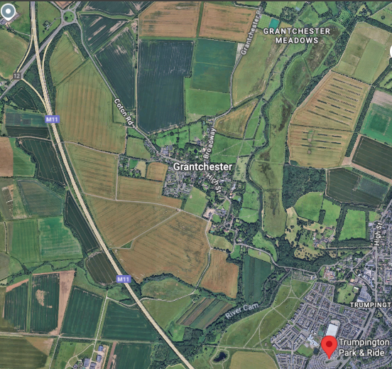
Above – from G-Maps here – the red balloon icon is where the Cambridge Guided Busway also terminates at Trumpington
Food for thought?
If you are interested in the longer term future of Cambridge, and on what happens at the local democracy meetings where decisions are made, feel free to:
- Consider a small donation to help fund my continued research and reporting on local democracy in and around Cambridge
- Follow me on BSky
- Spot me on LinkedIn
- Like my Facebook page

