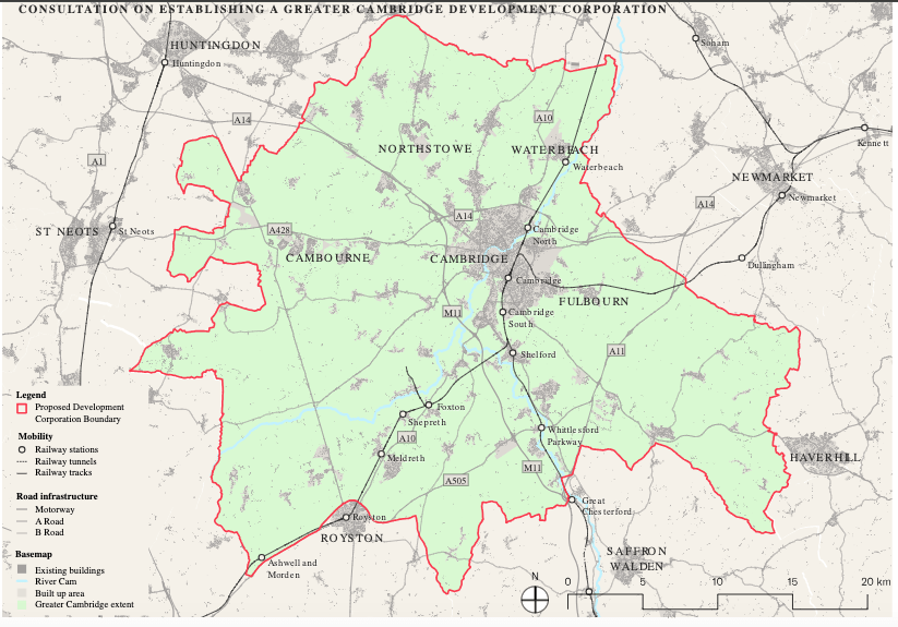
With Haverhill and Royston located just beyond the boundary of South Cambridgeshire, could both towns be included in the remit? (A separate question: Should they be included?)
Reminder: The consultation on a development corporation is still open
This is not a new question – it was a point of discussion in the 1960s when the Redcliffe-Maud report proposed incorporating both towns into a new ‘Greater Cambridge’ unitary council. The current proposals for ‘Greater Cambridge’ as of the Greater Cambridge Partnership cover a much smaller geographical area.
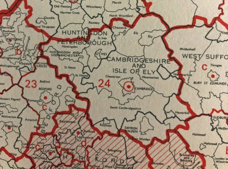
Above – left: Detail of Redcliffe-Maud (1969), and above-right, detail of the Cambridge Sub-region, Lichfield (1965)
The context for the recommendations in the 1969 Royal Commission that Lord Redcliffe Maud chaired included the rapidly-extending distances that employees were commuting to get to/from work. Part of the evidence base compared the figures of 1921 with 1966, asking what percentage of residents in rural districts commuted into urban areas for work.
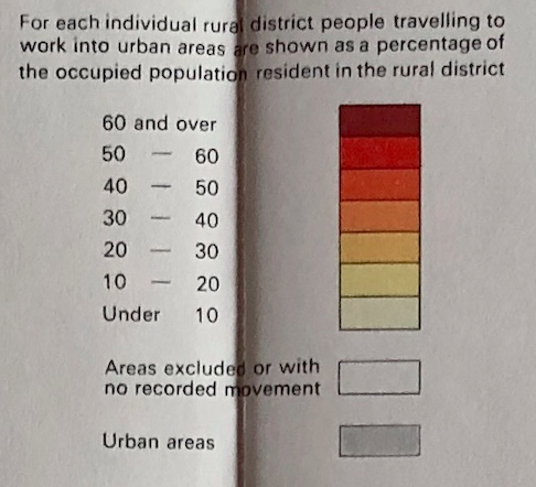


Above – from the Redcliffe Maud maps (vol 3 – commuting patterns 1921 – 1966), the map for 1921 on the left (small percentages of people in employment at specific addresses in urban areas) and for 1966 on the right (larger proportions shown by the darker shades from yellow-red-brown).
In the old Chesterton Rural District (The area surrounding Cambridge) the proportion of occupied persons commuting into urban areas rose from between 10-20% of the occupied population resident, to between 30-40% of occupied persons resident in Chesterton Rural District.
Any development corporation needs authority from Parliament (in the form of secondary legislation / a Statutory Instrument) to be lawfully established
That means that unlike the Greater Cambridge Partnership which was a contractual agreement between different parts of the state, the remit of a development corporation can go as far as the Act of Parliament’s enabling clauses allow for. In this case it’s likely to be the New Towns Act 1981 which was most recently amended by the Planning and Infrastructure Act 2025 at Part 4 (which is why reading Part 4 of the recent legislation alone doesn’t make sense to anyone! Unless they are an expert in planning law!)
“To secure such laying out and development every development corporation established for the purposes of a new town in England has the power (subject to section 5)—
- (a) to acquire, hold, manage and dispose of land and other property,
- (b) to carry out building and other operations,
- (c) to carry on any business or undertaking in or for the purposes of the new town,
and generally to do anything necessary or expedient for the purposes or incidental purposes of the new town“.
So in principle ministers could include settlements and plots of land close to Cambridge *but which are beyond South Cambridgeshire’s external boundary* as areas that fall within the remit of a development corporation. Note how close to the southern boundary the towns of Royston, Saffron Walden, and Haverhill are.
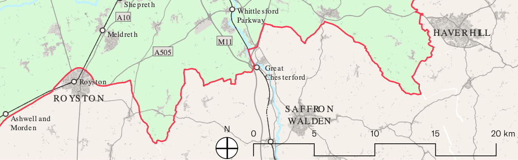
Above – detail of proposed development corporation boundary from Annex B of the consultation
In the cases of Royston and Haverhill, the distances involved are minimal, and may only be needed for the purposes of a new mass transit network for the Cambridge economic sub-region. (Alternatively, ministers may take a view that they want to include additional plots of undeveloped land for new housing – for example to ensure developers contribute to the costs of a mass transit system and to ensure that any new stations built become both financially viable *and* contribute towards alleviating the employment crises for employers on the Cambridge Biomedical Campus. At the same time, I have issues about the risks that such places become dormitory developments, contributing nothing towards the existing towns and communities. Solving Cambridge’s problems should not come at the expense fo creating new ones for surrounding towns and villages that they have no control over or responsibility for.
Cambridge Biomedical Campus identified rural stations in their housing report by Lichfields.
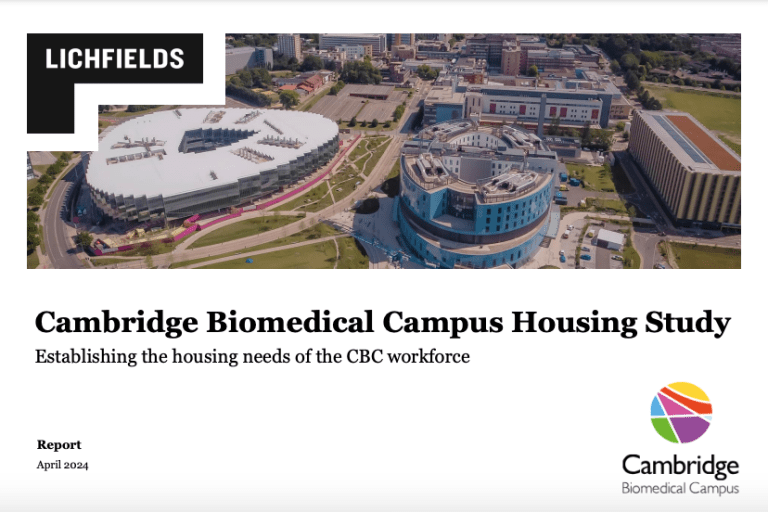
Above – I blogged about the April 2024 report here
That report identified that the CBC will need *up to 16,000 affordable homes* just to meet their need – which is far beyond the number of affordable homes that the emerging local plan is proposing for Cambridge and South Cambridgeshire. That doesn’t include market housing and does not account for the housing demand from all of the other employment sites such as RailPen’s new Beehive redevelopment which was recently approved by ministers.
Hence the call from Cambridge Connect Light Rail a couple of months after.
Above – Cambridge Connect Light Rail’s comment following the CBC’s press release. welcoming former Housing Secretary Michael Gove’s pre-election commitment to establish the Cambridge Growth Company as a development corporation in his ministerial statement of 26 March 2024 – followed up by a written statement to Parliament on 08 May 2024.
Keep an eye out for the papers for the Combined Authority’s Transport Committee meeting on 04 March 2026 – we may get a light rail update.
Because the Cambridge Biomedical Campus’s Housing Report identified the importance of rail-based public transport.
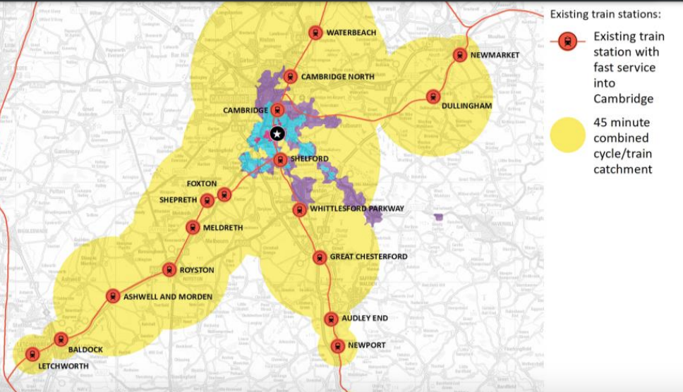
Above – Lichfields for CBC (2024) p26
With a number of existing rural stations linked to Cambridge, my first thought was on:
- Dullingham (Cambs)
- Kennett (West Suffolk just beyond Newmarket)
- Six Mile Bottom (Closed in 1967)
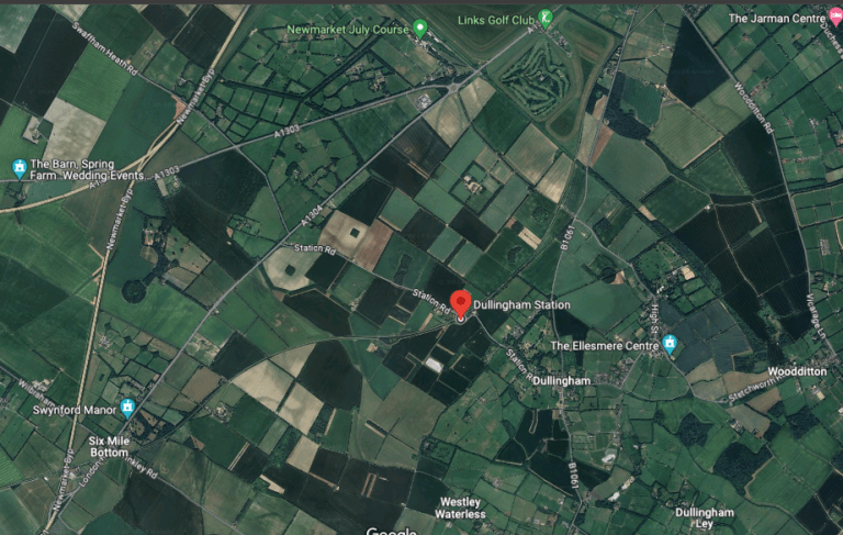
Above – G-Maps Dullingham Station surrounded by lots of green fields. Note Six Mile Bottom and the A11 junction are at the bottom-left of the image above
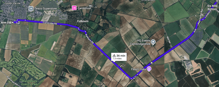
Above – Six Mile Bottom detail from G-Maps – with Fulbourn and what a cycling commute to ARM Ltd’s headquarters on Peterhouse Technology Park – owned by Cambridge University’s oldest college
It’s all very well having estate agents talking telephone number sums in press releases about future rents and expected yields, but a mile down the road towards and into Cambridge and the main road (Fulbourn Road leading into Cherry Hinton Road) the road surface and cycle lane surface looks like this.

Above – Photo by me from last week – which I blogged about here. Private wealth, public squalor is what HM Treasury oversees as it continues to block highways authorities from taxing wealthy institutions to pay for essential maintenance and new infrastructure
Note the Development Corporation’s remit is not to duplicate the powers of local government. The woefully-weak revenue-raising powers of local government in England remains an issue. And HM Treasury intransigence remains a barrier. Symptoms of that intransigence will continue to pop up like this all over the country. Which is why whenever ministers visit Cambridge it’s essential that those attending events where they speak at raise the governance and revenue-raising powers of local government. Because the risk is that this and other development corporations will initiate all of these new urban developments only for the new residents to find that their local councils do not have the powers needed to raise revenues to undertake even the most basic of maintenance functions.
“Housebuilding around train stations will be given default “yes””
Said ministers a few months ago.
I blogged about the Government’s announcement from November 2025 here.
“You can read the Secretary of State’s statement here, and the joint press release with The Chancellor here.”
The headline was:
“Housebuilding near well-connected train stations will receive a default “yes” in future if they meet certain rules, ensuring more high-quality, affordable homes are built in and around our key towns and cities, saving commuters time and boosting access to housing.”
What those ‘certain rules’ are is part of the consultation on national planning policy framework changes. (See the consultation here, in particular Section 12 on Effective use of land.) One of the criteria that ministers propose is that the rule only applies to the top 60 Travel to Work Areas in England. So it won’t be a nationwide blanket policy.
“Where is Cambridge in that top sixty of travel to work areas?”
At number six. Which means the rural stations are prime candidates. Furthermore, the most recent definition of Cambridge’s Travel to Work Area (TTWA) is from East Cambridgeshire District Council for their evidence base on the restructure of local government. The last national TTWA survey was taken in 2011 as it’s based on census data. Because of the 2021 lockdowns that part of the census was dropped due to the Furlough arrangements and the unusually high number of people working from home. But given the development corporation will last for 20+ years, we should expect revised TTWA assessments from 2032 – which will inevitably be different due to the new infrastructure that has already been built, and is due to be built between now and then. (Eg Cambridge North Station, and Cambridge East Station respectively)
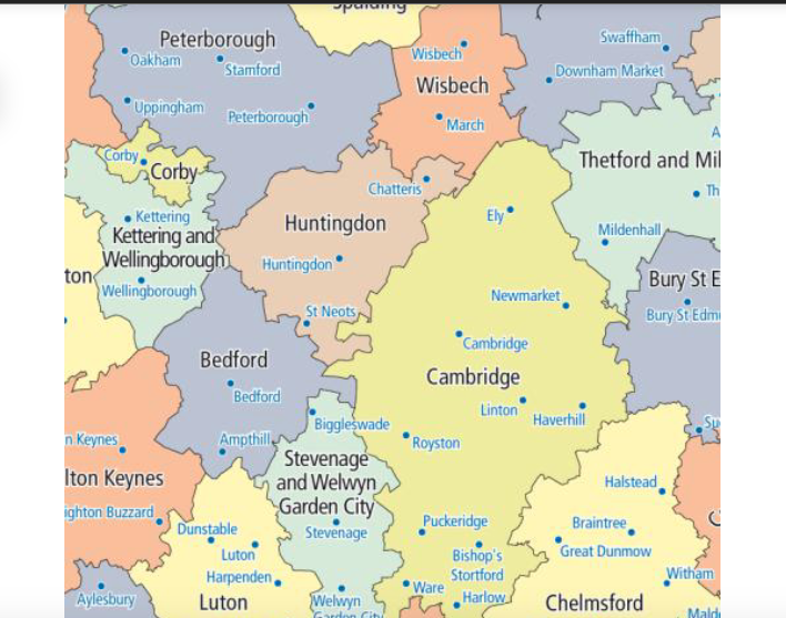
Above – Cambridge Travel To Work Area (based on 2011 Census Data)
Which very clearly goes far beyond county boundaries and incorporates lots of existing rural stations in the Government’s proposed policies on new housing around rural railway stations.
This means it won’t just be the handful of rural railway stations east of Cambridge that will interest ministers and developers. Others include:
- Whittlesford Parkway
- Foxton (and Shepreth)
- Soham
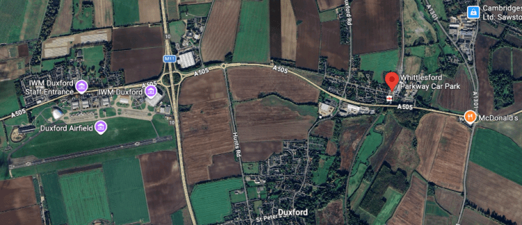
Above – Whittlesford Parkway (on the Cambridge – London Liverpool Street line) on G-Maps with IWM Duxford and Duxford Village nearby, the latter two separated by the M11 motorway, and village pedestrian access blocked by the A505
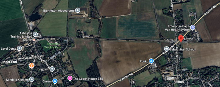
Above – Foxton, and Shepreth (the latter with the wildlife park, the former with the long-called-for bridge taking the A10 over the railway line)
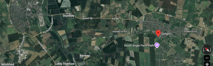
Above – Soham (and to its NW, Ely,) the map slightly rotated as is the Foxton & Shepreth one.
“Hang on – none of those sites are in the draft Greater Cambridge Local Plan!”
This is why ministers are going out to consultation now – and have included questions on it as part of their updated of the National Planning Policy Framework (NPPF) which applies to all planning applications.
The NPPF Consultation closes on 10 March 2026
“For development around well-connected stations, we are proposing a minimum density requirement of 50 dwellings per hectare within the net developable area of the site. We consider this will be sufficiently ambitious in some locations, particularly locations outside of settlements, and will act as the minimum requirement for other locations”
Above – NPPF Consultation, Section 12: Making Effective Use of Land
The reason for this is to ensure service improvements are financially viable for train operators – the consultation says that services should expect to run at least 4 services per hour, two per hour in each direction.
This could get very messy…
…with land speculators buying up sites/options and submitting wholly unsuitable developments around stations with little consideration of the needs of villages
Which is why one option is to use the Development Corporation’s powers to do the opposite of what people fear it might do. i.e. provide the Development Corporation with powers of compulsory purchase *and* powers to create masterplans for sites outside of Greater Cambridge but which are within the vicinity of rural railway stations that sit within Cambridge’s Travel To Work Area.
Because the powers of the Development Corporation are going to be set in legislation, there is much greater scope for adding things in that might benefit the people over profit-maximising corporations/developers. For example the hospitals on the Cambridge Biomedical Campus may negotiate with the Development Corporation to have keyworker housing on the doorstep of rural railway stations. Thus providing point-to-point services to Cambridge South Station. As masterplanners for specific sites, the Development Corporation would designate specific sites for a specific use. That means developers could not build luxury apartments as investment properties for the international market.
Note this will also require consultations with the local councils outside the Development Corporation boundary and outside of the Combined Authority (soon to be Strategic Authority) areas.
Cambridge’s TTWA incorporates bits of West Suffolk District, most of East Cambridgeshire District, bits of NW Essex / Uttlesford District, and a large chunk of Hertfordshire County.
Those negotiations will need to identify and evidence the needs of the people already living in the vicinity of where new developments around rural stations could go. That means developers funding more than the bare minimum for the newbuild residents – noting that historically the developers have under-provided the required amenities in previous phases of development. In principle that sort of corner-cutting and cost-reduction-based profiteering should be much harder with a Development Corporation. But that will depend on the cultures and values of the people who end up in senior executive roles in that institution.
We live in uncertain times.
All the more reason for more residents to get involved in local democracy. Keep an eye on https://whocanivotefor.co.uk/ for when the candidates lists are published for the elections in just over 2 months time.
If you are interested in the longer term future of Cambridge, and on what happens at the local democracy meetings where decisions are made, feel free to:
- Follow me on BSky
- Spot me on LinkedIn
- Like my Facebook page
- Consider a small donation to help fund my continued research and reporting on local democracy in and around Cambridge

