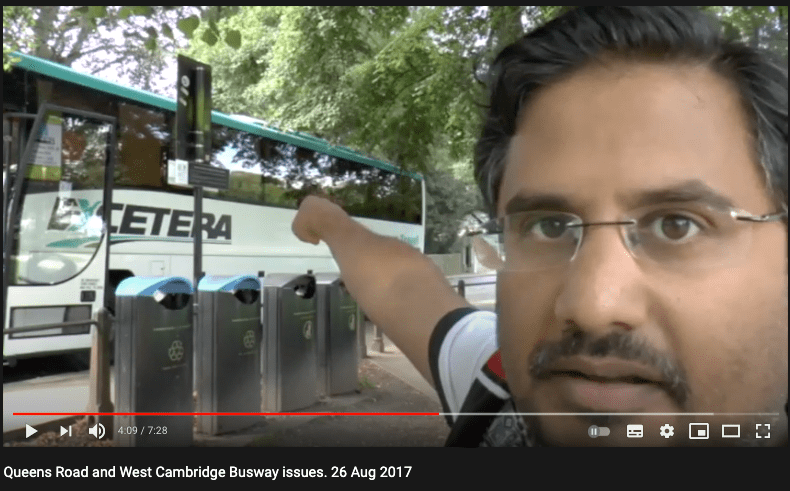
Above – me on Queen’s Road Green, pointing towards West Road – and Grange Road beyond it, from way back in 2017.
The same question applies for the CSET buses from the east when they hit Addenbrooke’s?
Only I’ve been asking these questions for years. ***Look at how much hair I have! (and how few greys there are!) I remain convinced that the Greater Cambridge Partnership (GCP) amongst other things suffered from not having a ‘year zero’ planning phase to get all of the essential appointments and structures in place before looking at possible solutions. Hence the over-dependency on senior county council officers at the start, who led off on a second busway shortly after the opening of the controversial Cambridge-St Ives guided busway, the legal proceedings on that one are still ongoing between the county council and the main contractor Balfour Beatty.
The Business Case for a Cambourne to Cambridge segregated off-road busway
You can read all of the documents here.
In the hundreds – if not thousands of pages of evidence and discussion, the bit I want to focus on is this:
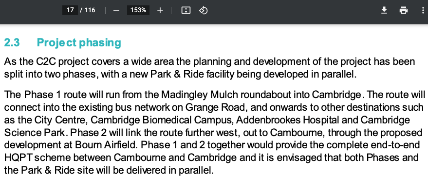
It is from Appendix 1, the Strategic Business Case of early 2020. ( “C2C- JAN 2020 – APP 1 – STRATEGIC CASE” )
“The Phase 1 route will run from the Madingley Mulch roundabout into Cambridge. The route will connect into the existing bus network on Grange Road,”
Just to make sure you’ve noticed the important bit. “The route will connect into the existing bus network on Grange Road.” What bus network? There is no bus network on Grange Road. There is a short stretch where the Uni bus service operated by Whippet passes, but this is not integrated into a single ticketing system. I know because I’ve lost count the number of times I’ve paid for two sets of tickets – one for the Stagecoach network and one for the Whippet Network. I still blame the Tories for privatising the buses in the 1980s. (I hold grudges for a very long time – especially if they are political!)
“Do people from the western towns and villages want to get to Grange Road as a destination?”
Not to the extent they might want to get to Addenbrooke’s, the Science Parks, or the City Centre. And there are *no plans* for what those bus routes might look like, nor is there any plan for a terminus at any point on Grange Road. Furthermore, you can imagine the uproar there would be if they selected the green on the corner of Queen’s Road / Silver Street as a new bus station.
Anyway, Let’s have a look at what the Independent Audit (See the intro pages here) said:
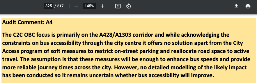
“[The Cambourne to Cambridge Busway Project] …offers no solution apart from the City Access program of soft measures to restrict on-street parking and reallocate road space to active travel. The assumption is that these measures will be enough to enhance bus speeds and provide more reliable journey times across the city. However, no detailed modelling of the likely impact has been conducted so it remains uncertain whether bus accessibility will improve.”
Agenda Pack for Greater Cambridge Assembly, 20 June 2021 – p 325.
You can read the full independent audit from p306 of the Agenda Pack
Above – the front cover of the Independent Audit.
The case of what happens to the buses was also covered in some of the advanced questions sent in and discussed at the meeting of the Cambourne to Cambridge Supplementary LLF Meeting on Tuesday 2 June 2020. (Mindful of the delays caused by the Pandemic and Lockdown responses). One of them raised the issue of what happens to the buses from Cambourne. This from p440 of the Agenda Pack
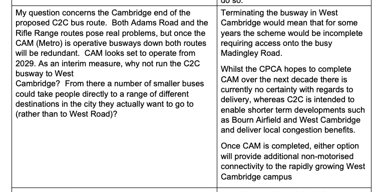
The response from Greater Cambridge Partnership:
“Terminating the busway in West Cambridge would mean that for some years the scheme would be incomplete requiring access onto the busy Madingley Road. Whilst the CPCA hopes to complete CAM over the next decade there is currently no certainty with regards to delivery, whereas C2C is intended to enable shorter term developments such as Bourn Airfield and West Cambridge and deliver local congestion benefits. Once CAM is completed, either option will provide additional non-motorised connectivity to the rapidly growing West Cambridge campus.”
From the Local Liaison Forum of 02 June 2021.
So I contend that the planning for Phase 1 of the Cambourne – Cambridge busway remains incomplete. It makes no provision for what is the biggest and most challenging transport challenge: That final mile at the Cambridge end. This is one of the reasons why I favour the Cambridge Connect Light Rail concept – only in the case of the map below, I’d extend the underground tunnelling section westwards from Grange Road out to the Girton Interchange so as to alleviate the environmental concerns of those in and around West Cambridge.

Furthermore, it opens up the opportunity for the Girton Interchange as a possible freight exchange site and a tourist coach passenger exchange site for groups coming from the north and west UK.
Dealing with South East Cambridge – in the news today.
A consortium of elected representatives and campaign groups in and around South East Cambridge have written to the Greater Cambridge Partnership Board.

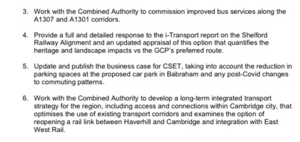
Above – the issues and proposed way forward raised in the letter.

Above – the signatories
Note in point 6. the signatories call for the re-examination of the Haverhill-Cambridge corridor. Does that sound familiar?
The first call for evidence by the then Greater Cambridge City Deal: 16 November 2015.
Above – me making the case for incorporating the work of the Rail Haverhill Campaign (back then, little known in Cambridge) as one of the schemes for the City Deal.
Why does this matter? Because the former Director of Stagecoach Cambridge, Andy Campbell made it crystal clear what he considered the most congested part of the road network for his buses.
Therefore, if the Greater Cambridge Partnership is to make a real positive difference to commuters coming into Cambridge from the South East of the city, dealing with the Addenbrooke’s – Cambridge Railway Station – Cambridge City Centre spine is essential. What a Rail Haverhill option (Whether via heavy or light rail) provides for is for passengers to alight at the looming Cambridge South Railway Station for Addenbrooke’s / Cambridge Biomedical Campus – which is now at a much more advanced stage, with certainty of the location now assured. Furthermore it takes cars and passengers off Babraham Road / Hills Road into Cambridge, and opens up the employment sites and Cambridge Regional College at Cambridge North with the guided bus interchange. Finally, a rail link from Cambridge to Haverhill could make Cambridge City Council’s investment in Cambridge Road Retail Park in Haverhill back in 2015 look like a bargain should it become one of the light rail stops.
“Why didn’t Rail Haverhill get approved in the first place?”
Controversial point.

Above – from the minutes of Wed 1st March 2017. It reads”
“A Cambridge-Haverhill railway line had been discounted for the following reasons:
- [Heavy] Rail was a very expensive form of infrastructure to deliver. This scheme would cost £390million, with a very low benefit to cost ratio (BCR). The scale of the scheme and likely benefit could not justify City Deal Investment
- Capacity constraints of sharing light rail with heavy rail existed south of Cambridge Station
- Part of the track had been removed between Cambridge and Haverhill, making reinstatement difficult and expensive”
Which makes this point by Dr Colin Harris of the Cambridge Connect Light Rail Project interesting:
Above – a possible question to table to the GCP Board Meeting?
The problem with the GCP’s response however, is that the then City Deal Officers *did not fully answer the question*. This reflects why the politicians have come back with a request to re-examine the Haverhill Rail/Light Rail case once again – whether as a heavy rail link, or whether as part of the Isaac Newton Line of the Cambridge Connect Light Rail Project, which links Cambourne – Cambridge – Haverhill, covering both Addenbrooke’s/Biomedical Campus in the south, and the Science Park in the North.
“What did you ask?”
I noted that the consultants that did the technical assessment were given *very narrow* terms of reference. They were directed to assess the BCR of the heavy rail link only.


“I note the City Deal Board rejected Rail Haverhill’s proposals in Feb 2016. I would like to challenge that decision based on incorrect assumptions given to the consultants in carrying out their assessment as described in the draft rail viability technical note Jan 2016.”
“The authors state:
“A Cambridge-Haverhill railway line could also ultimately form part of a more strategic rail link from Cambridge to Colchester, via Haverhill and Sudbury, including the existing Sudbury to Marks Tey branch. However, this strategic option is beyond the scope of this technical note and the current study.”
“This strategic option is central to the business case for Haverhill, for it links by rail the two campuses of Anglia Ruskin University (Chelmsford & Cambridge via Colchester)
Who made the decision to restrict this strategic option for Rail Haverhill to be between just the town and Cambridge Station?”
I never found out who made the judgement call to have such a narrow term of reference. Fast forward to 2021 and a number of climate targets have been moved forward – including the proposed restrictions on sale of petrol/diesel fuelled motor vehicle to 2030. Furthermore, Parliament has declared a climate emergency – as have the local councils. Lockdown has also demonstrated that the public’s mood towards valuing open green spaces and lower air pollution has risen significantly. Finally we are at the stage where there is a credible alternative to the limited technical assessment of the Haverhill-Cambridge route. And that’s before we’ve looked at the political element of the opposition to the current option that the GCP wants to go ahead with.
Cambridge City Centre Access following the proposed scrapping of the CAM Metro
The website of the CAM Metro has been updated since the Mayoral Elections.
“Work on the Cambridgeshire Autonomous Metro (CAM) has stopped in advance of a review of the programme by the Combined Authority Board”
“Mayor Dr Johnson has also placed an emphasis on working collaboratively with partners including the Greater Cambridge Partnership, the OxCAM Arc and East West Rail, to deliver effective transport solutions across the region.”
https://cam-metro.co.uk/
For the busways to have any chance of success, they needed something substantial in that last mile in central Cambridge. The Independent Audit raised this issue – quoted at the top of this blogpost. It’s hard to see how the Greater Cambridge Partnership proceed further without dealing with an issue that it has put off for far too long. Simply stating it will rely on the existing bus network – where the main bus operator does not operate City services in West Cambridge is simply not good enough.
One of the weaknesses of the GCP / City Deal raised very early on in the process was not having Stagecoach or Whippet represented on either the board or assembly given how integral buses are to their existing proposals. The powers of bus franchising Mayor Dr Johnson has will enable a more strategic plan for bus services, but it’s hard to see how these will be the game-changers needed on their own. Especially given the austerity with bus services and the increasing expense of them over the past decade.
“What if the GCP continues as normal?”
They risk making the same mistakes of Messrs Holford and Logie. Let’s look at some of them: Below, from Holford & Wrights Cambridge Development Plan 1950.

You can read the digitised report (without the maps) here.
The plan was to have an eastern inner spine road through Cambridge. This is why Park Street Car Park was built. The plan was to enable people to park in the city centre, serviced by two new roads – one over Christ’s Pieces, and another over Jesus Green with a new road bridge over the Cam at the western end of the Green, with a further link road towards the junction of Histon Road, Huntingdon Road and Castle Street. The Car Park got built. The rest stayed on paper.
Another eastern spine road – Elizabeth Way Bridge as a piece of stranded infrastructure

The parliamentary authority to build Elizabeth Way Bridge was secured in Queen Victoria’s reign. But construction did not begin for another 80 years. World wars got in the way amongst other things.
As you can see from Holford-Wright left, the plan was to plough a main road from Cambridge Station through Petersfield/St Matthew’s towards the East Road/Newmarket Road Junction. The plan was to link Milton Road. in the north to the Railway Station in the south. (Rather than just having Cambridge North instead)
This did not get built for a number of reasons – including local opposition to having their houses demolished. As it was, the residents of Walnut Tree Avenue and Abbey Road were the residents affected the most, the former pretty much ceasing to exist as a functional residential road.
Note at the foot of the map there is the as yet still unbuilt footbridge over the railway line at the station, creating an Eastern Entrance to Cambridge Station (along with a bus terminus) that was first mentioned as an option just before the First World War. We are still waiting!
.

The final piece of stranded infrastructure is Barnwell Road. The plan was to have a ring road around the City. King’s Hedges Road – Green End Road – Flyover across the river and Stourbridge Common, Wadloes Road, Barnwell Road, Brookes Road, Perne Road, Mowbray Road, Fendon Road, Addenbrooke’s.
On paper it sounds ever so simple, but building across Stourbridge Common proved anything but. The plans were abandoned, leaving what might have been a dual carriageway along Barnwell Road to become something of an under-used cycleway – mainly I think due to the design of the Sainsbury’s Roundabout on Coldham’s Lane which is a nightmare to cycle around.
“So…what happens next?”
We wait to see what the Board says at their meeting on 01 July 2021.
You have until 28 June to submit any questions for that board meeting. (See here for details).
- Follow me on Twitter
- Like my Facebook page
- Consider a small subscription or donation to help fund my continued research and reporting on local democracy in and around Cambridge.