The Mayor for Greater Cambridgeshire (i.e. Cambs & Peterboro’) was challenged by the Leader of East Cambridgeshire District Council on a ‘beyond buses’ scenario at the last Combined Authority Board Meeting. (*Note as with all of the other posts, the content & opinions are mine, & not necessarily of any other individual, group, organisation, institution, collective, alliance, federation, partnership etc unless they otherwise state as such)
You can watch the exchanges below: (Timestamp: 1h04m35s)
Above – Video of the July 2021 Combined Authority Board Meeting – you can see the papers here.
The exchanges between Cllr Anna Bailey (Cons – Downham) & Mayor Dr Nik Johnson are also covered in detail in this week’s (04 June 2021) Cambridge Independent Newspaper.
“Scrapping the metro leaves us with no plan”
That’s the headline/accusation Cllr Bailey levelled at the Mayor. A reasonable challenge from the former to the latter. What is the Mayor’s long term plan? At the moment we don’t know. One of the reasons for scrapping the CAM Metro the Mayor gave during his election campaign was that the Combined Authority simply did not have the budget to deliver such a Metro, nor did it have the legal powers to use Land Value Capture (described in this Parliamentary Report) to provide for such a funding mechanism. This was the point Cllr Lewis Herbert (Labour – Coleridge), Leader of Cambridge City Council made in support of the Mayor in response to Cllr Bailey.
Improve the bus network in rural areas – and improve it quickly, and with greener buses
Note to Combined Authority officers – please update your bus page.
Just before the Mayoral Election earlier this year, Dr Nik Johnson confirmed that bus franchising would be his key transport priority. Other commitments he made in a piece for the Cambridgeshire Times included:
- Free bus travel for 16 to 18-year-olds, and a means-tested subsidy to under 25s (makes sense given the minimum wage differential)
- Rebranding the bus fleet along a “Fen Tiger” theme (a nod to local history)
- Exploring the possibility of a busway into the Fens
- Asking the Greater Cambridge Partnership to “reconsider” its proposed Cambridge South East Transport busway route.
Personally I’d prefer a light rail network into the Fens.
Thinking ***very long term*** – perhaps fifty years ahead? Playing with G-Maps on some Light Rail extensions.
First of all, the theme for a light rail network has to go beyond simply serving employment sites, or being A-to-B type lines. Can they also be designed to build in resilience to the transport network so that if one line goes down, passengers can switch to another line or mode of transport easily, even if it means using a slightly more elongated route? Can it also be designed to serve health and leisure purposes as well? Can it enable different towns and villages to develop facilities they already have that other places do not have, so that one attraction can serve a wider catchment without others needing to build similar?
Note John Lewis Parry’s radical study of the Cambridge sub region in the 1970s covered towns outside Cambridgeshire’s county boundaries. (See Lost Cambridge here)

Above – Royston (Herts), Saffron Walden (Essex), Haverhill (Suffolk) were all included.
Several of you will be familiar with the Cambridge Connect Light Rail proposals

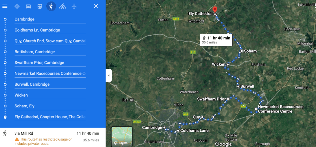
As mentioned in my Darwin Line blogpost here, there is the possibility of amending it to cover a Phase 2 extension to Burwell & beyond. I played with G-Maps here.
Linking Saffron Walden to Haverhill to create a South-east-of-Cambridge loop.
This extends the first phase of the Cambridge Connect model.

It’s just over ten miles between the two towns. What this does is it links an additional later phase: Cambridge – Sawston (& Cambridge City Football Club‘s new ground) with Duxford (& the Imperial War Museum) and Saffron Walden. This opens up Saffron Hall – the music venue.

North-east of Cambridge and beyond
Above – a possible Phase II extension of Cambridge Connect’s Darwin Line – instead of heading to Addenbrooke’s – already covered by the first Isaac Newton Line, this option deals with the lack of public transport East of Cambridge given the very poor suburban rail service from Greater Anglia (which uses diesel trains) and the Beeching-era closure of the Cambridge-Mildenhall line.
From Burwell, the line moves up to serve Wicken Fen Nature Reserve – increasing visitor numbers while reducing the numbers of cars, before connecting to Soham (popn 10,000) and Ely. (Popn 20,000). What the last two stops provide is extra resilience for the wider transport network when transport links from Cambridge to Ely break down or have unexpected congestion. It’s not the shortest, fastest route to take, but it’s a backup if the normal route breaks down.
Serving Centerparcs at Thetford, and RAF Lakenheath.
One of the other options is making use of as much of the old Cambridge-Mildenhall Branch Line as possible, serving the air base there, and extending the route to serve the Elveden Forest Center Parcs holiday centre, Thetford, and terminating at RAF Lakenheath.

Above – a Cambridge-Lakenheath route on G-Maps.
North-west of Cambridge – linking up with mid-Cambridgeshire’s towns and larger villages such as Ramsay and Chatteris
I played around with G-Maps here to see what a north-west-of-Cambridge light rail line might look like, using the walking route option to get a feel for what distances are involved.

Above – a possible North-west-of-Cambridge light rail line
Again, there is nothing to stop this line becoming circular, joining up with the Cambridge-St Ives – Huntingdon busway. When the busway breaks down (as it inevitably does), this option provides the non-road alternative that passengers can use if they are in Cambridge and need to get back to Huntingdon. It also provides the residents of Chatteris, Ramsay, and Alconbury towns with public transport links they currently don’t have, which then makes them more attractive for firms to relocate to, from over-crowded Cambridge.
Light Rail transport stops can also be interchanges for light rail networks based around other cities – like Peterborough
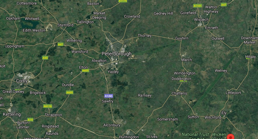
Let’s take Peterborough and region on G-Maps, and in the screenshot below.
Then also look at the old Railway Map of England and zoom in.
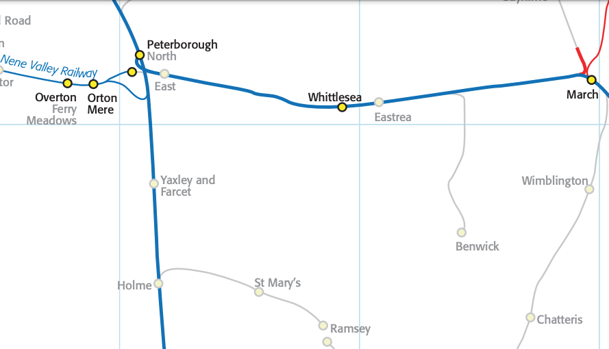
Above – Peterborough (in a very small font!) with existing (blue), closed (grey) and proposed (red – to Wisbech) rail lines on New Adlestrop.
One option The Mayor has is to explore a light rail line from Wisbech to Peterborough via Chatteris and Ramsay. They could even even double-up on the same pair of lines used by a proposed Cambridge – Ely – Chatteris – Ramsay – Alconbury line. This would mean firms could set up at either Ramsay or Chatteris and serve both the residents of Peterborough and Cambridge with a light rail link.
Could similar principles of ‘doubling up’ on light rail lines work elsewhere?
The concept is two separate light rail networks based around two different cities sharing for short stretches the same lines and stations, thus creating light rail interchanges.
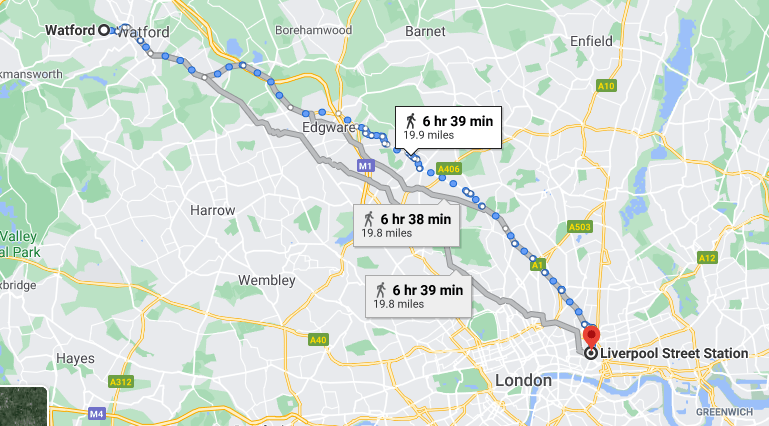
I generally take the 20 miles of the Metropolitan Line between Watford & Liverpool Street in London (1 hour or so either way) as the approximate limit of light rail. (Note the time on the image below are walking times – but they also show approximate distances point-to-point not taking big detours.
How about Luton?
Out of our remit, but worth a look. This is one for Bedfordshire and Hertfordshire. There’s no rail link between Luton and Stevenage.
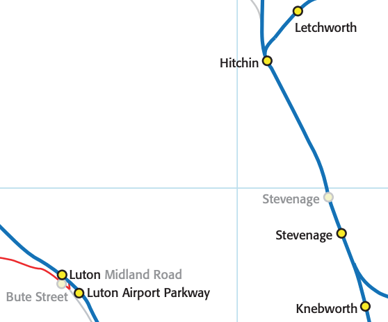
….which I think is an error in the Government’s OxCam Arc proposal.
Given the industry based in Stevenage, and the Luton-Dunstable Busway, for me I don’t see why it should not be extended eastwards to Stevenage and ultimately Knebworth Adventure Playground.
Could a Norwich light rail extend to Thetford?

It’s a stretch at 30 miles. Which shows that for all the publicity of the Norwich-Cambridge Tech Corridor, the rail network between the two needs significant improvement.

Above – I’ve said in the past that a Cambridge – Norwich [UEA and Airport via tunnels] – Great Yarmouth heavy rail line (this one via Mildenhall) would be beneficial both as additional capacity for Cambridge-Norwich, and also as a means for rejuvenating Great Yarmouth as a seaside resort. It takes just over 80 minutes to get from Cambridge to Norwich on the stopping diesel train. An electrified and upgraded railway line would be able to do that journey much faster. Again, the question isn’t just about jobs, but also how we can use improved public transport to make places suffering from poverty and multiple deprivation more connected. This is Norfolk.

Above – from the Eastern Daily Press here in May 2021. You can see how prominently Thetford (unlabelled, bottom-left), Swaffam, Norwich, and Great Yarmouth are prominent.
“It’s all pie-in-the-sky, isn’t it?”
Yes
It does however give an idea of the scale that councillors need to be thinking about if they want to catch the attention of ministers and civil servants. Because it’s a significant lifestyle change that is looming. We can either do it voluntarily or wait until the climate emergency gets so bad that it forces that change upon us.
If you are interested in the longer term future of Cambridge, and on what happens at the local democracy meetings where decisions are made, feel free to:
- Follow me on Twitter
- Like my Facebook page
- Consider a small subscription to help fund my continued research and reporting on local democracy in and around Cambridge.