On why large plots of land just north of the A14 dual carriageway need to be designated as areas for future parkland, open spaces and nature reserves – and why large green bridges with gentle inclines over the trunk roads need to be built.
Some of you may have seen the headlines regarding the Milton Park Run – now called off. This post looks at why there is not enough open green space for the people of North Cambridge – even though it was identified back in the 1970s as a collective need.
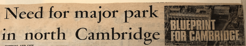
Above – from the Blueprint for Cambridge articles in the Cambridge Evening News in late November/early December 1975 in the Cambridgeshire Collection. The required land was never designated.
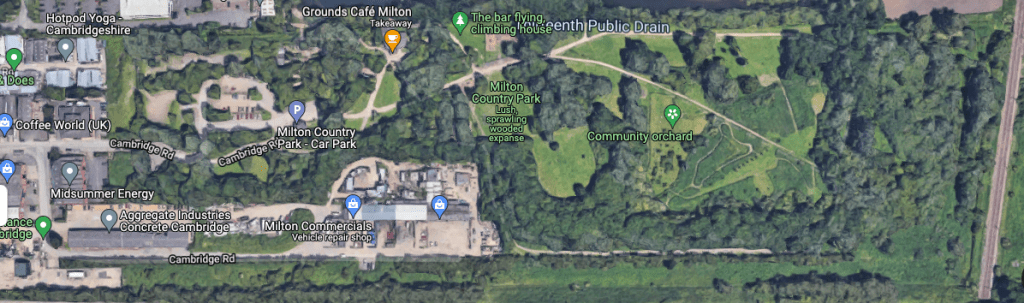
Above – Milton Country Park on G-Maps here – it’s not as if the park itself can serve much more than the village of Milton anyway – a small plot of land next to some lakes that were previously quarries.
Town planning and transport planning
Cllr Sam Davies (Ind – Queen Edith’s wrote the following:
“The link between the planning system and transport delivery is broken.“
https://sam4qe.com/dark-week/
“So…what broke it?”
Successive pieces of legislation passed by various governments, but the ones that stand out for me are the Transport Act 2000 (in particular Part II on Local Transport Plans), and the Planning and Compulsory Purchase Act 2004, in particular Section 15. The problem is that so many amendments have been made to the legislation since then, and so much secondary legislation has been made via the empowering clauses that it’s very difficult for anyone to keep up with who is required to do what – or not, as may be the case.
But North Cambridge’s problems go back long before these pieces of legislation were enacted.
Before we go back in time,
The question I’ve looking at here is why hasn’t North Cambridge been provided with nearly enough open space?
Let’s look at the G-Map.
Above from G-Maps which you can explore more closely here – I’ve slightly tweaked the orientation so that the A-14 is horizontal and the western part of the adjacent M11 to the west of the city is at right angles to amplify the points I’m about to make.
The original plan in the 1930s was to build a ring road around Cambridge. We know this because the Davidge Report from 1934 told us this with a big colourful map, the detail of which is below.
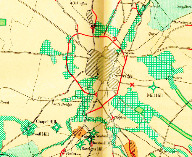
Above – Davidge’s proposed ring road for Cambridge – the eastern side is Mowbray Road/Perne Road/Brooks Road – which also indicates how far the housing development down Cherry Hinton Road (where the X and Mill Hill are labelled) had reached.
This is also the first plan where large tracts of green space were designated as being places where housing and development should be prohibited. In the grand scheme of things Davidge – and through him the Committee Chairman a certain Cllr Dr Alex Wood (Labour – St Matthew’s) put a stop to the threat of ribbon development in the south-eastern edge of the city.
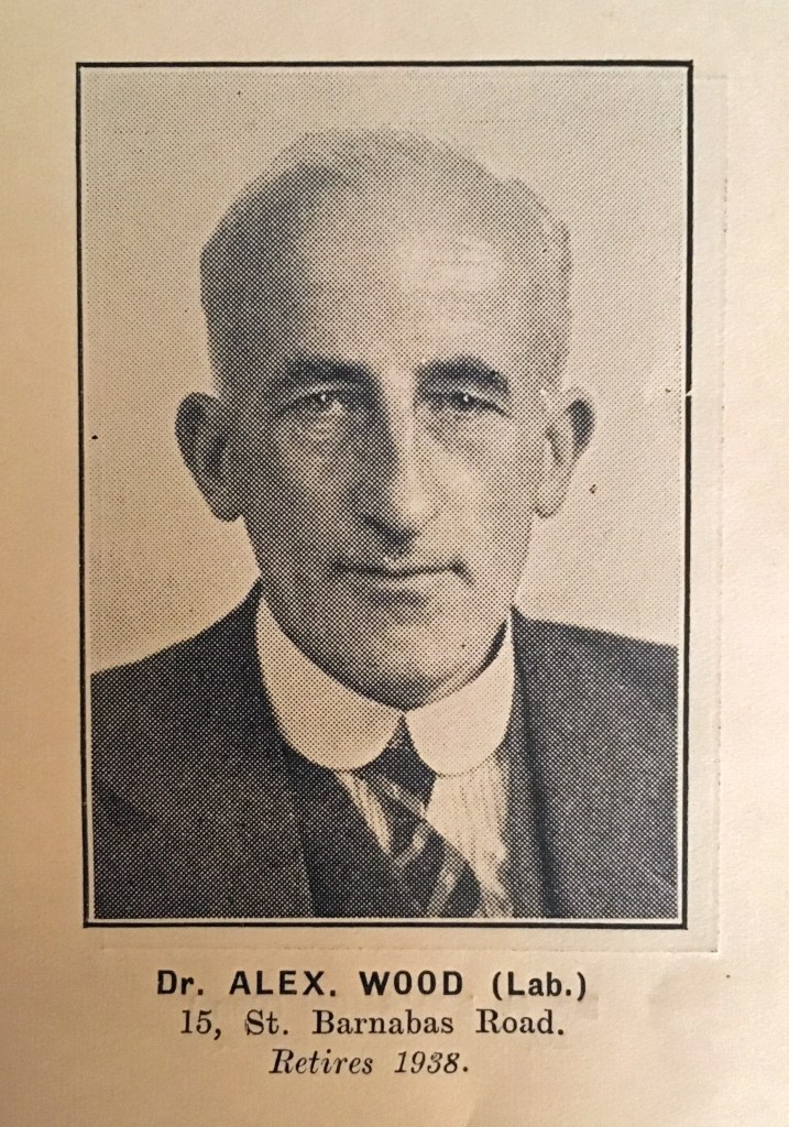
Dr Alex Wood, Leader of the Labour Group on Cambridge City Council, and their Parliamentary Candidate for Cambridge 1931-1935. He chaired the Cambridgeshire Regional Planning Committee in the 1930s which oversaw the work of William R. Davidge the town planner.
Such was the pace of road transport traffic growth that the proposals from the interwar period – and even from the Holford-Wright report in 1950 became obsolete, resulting in Central Government taking over with their schemes for a dual carriageway linking the Eastern ports to the Midlands (now the A14), and the M11 extension to Cambridge that had previously linked Bishop’s Stortford & Hertfordshire to East London.
Back to the analysis by local architect Charlotte Stuart.
I think her analysis, proposals and ideas in her maps and visions here are superb.
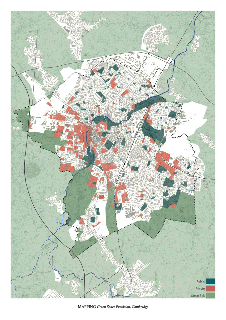
Above – by Charlotte Stuart here provides a textbook example of how councillors, planners, and developers (as well as activists) should be looking at green spaces: accessibility matters.
If the kids can’t access it, it may as well be green concrete.
Well…maybe not quite, but the point remains that too many children are shut out from large open spaces in their neighbourhoods. Furthermore, successive local plans have resulted in the piecemeal expansion of uninspiring suburbia that at the same time continues to under-provide for essential community, leisure, and sports facilities.
The north-westward expansion of the city towards the intersection of the M11 and A14 means that there is no large open green space for children – in particular teenagers – to play team sports. It’s the same in South Cambridge where since the late 1990s when large playing fields were properly secured, new generations of children were unable to play in the spaces that my generation took for granted. Despite repeated representations on my part to local councils – even during the lockdowns, there was no movement in getting any of those spaces re-opened despite the raised awareness of the importance of open green spaces and parks.
Busy roads as impassable walls
This was a concept that Ms Stuart examines in her portfolio of ideas, and one that needs to be explored more widely. For the A14 as it runs along the north of Cambridge has the form of an impassable wall. Furthermore, with the spread of housing now hitting the edge of the road, developers had to build thick, high walls as sound and pollution barriers to reduce the disturbance from the traffic.
Green bridges – or Ecoducts
The UK Government has a small page about them here. Yet examples of what are essentially bridges covered in a mix of grass, trees, vegetation and maybe a few footpaths, are very few. Essentially they form safe land bridges for migrating and moving wildlife to cross without running the risk of being hit by motor traffic.
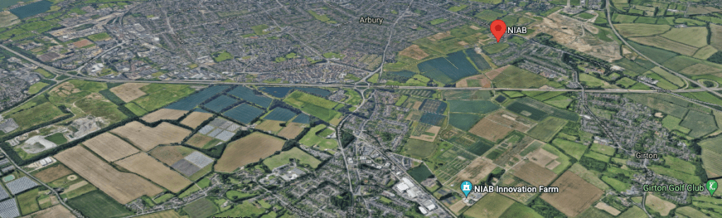
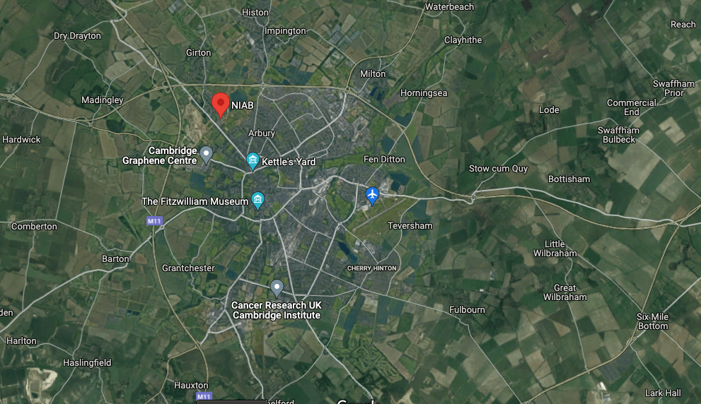
Above – a 3-D view looking southwards with the same NIAB building labelled in the red balloon. If the planners and politicians want to secure the two sets of fields currently used for what I call industrial agriculture (it’s intensive arable farming, but either way it’s not picturesque countryside with ease of public access) they’ll need to move quickly.
The bid for a new large science park
I wrote about Science Park North back in May 2021 here.
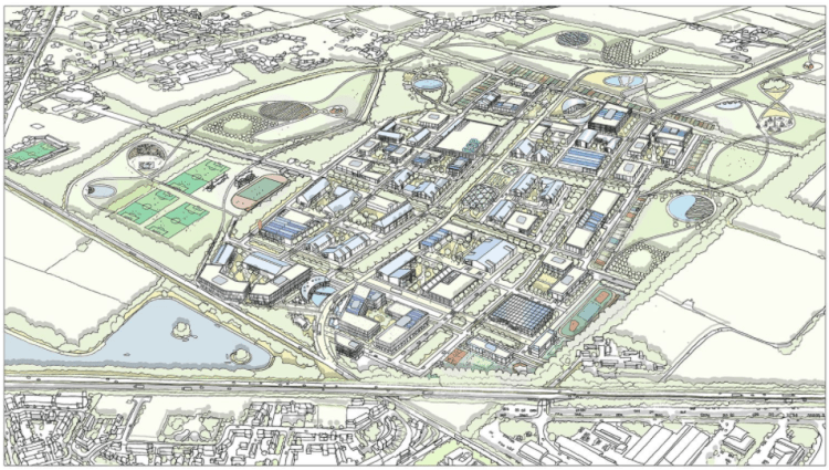
Above – a conceptual diagram submitted to the Greater Cambridge Planning Service in the emerging local plan
Although not included in the first draft, I’d expect them to come back and make the case in the public hearings. If not included in the 2030-41 round, I’d expect this to come back again at a future round. Unless that is the site is specifically set aside for a mix of a nature reserve, open parkland, woodland and playing fields – with multiple legal locks to protect the land.
The failure of long term large scale strategic county and regional planning?
For better or worse, Cambridge somehow managed to create a system that prevented successive generations from building on large plots of open green spaces in the town centre. That’s why you have ‘The King’s College Chapel Tourist Money Shot’ as I pejoratively call the view from Queen’s Road. It’s the one you see on all the postcards. You see the King’s Parade money shot whenever tabloid newspapers are talking about Cambridge University for good (“Discovery made by boffins to thwart killer disease!”) or the bad (“Big-headed boffins exposed as Woke warriors willing to betray Brexit”)
So how is it that the institutions that gave us not just the buildings but the landscapes that successive generations have handed down for centuries have not been able to stop some of the architecture and urban design that led to a best-selling book being critically acclaimed for all of the wrong reasons? (Hideous Cambridge if you were wondering).
Those institutions were far from perfect as we all know
More to the point, who needs to do what to ensure that the two remaining areas of open undeveloped land can be used not only for the public’s wider benefit, but also to help preserve enough open space so as to help improve Cambridge’s notoriously poor air quality?
Furthermore, much as I go on about big infrastructure like Cambridge Connect Light Rail, for something like those open spaces to be accessible to families say at King’s Hedges Primary School, the paths to and from the residential areas have to be safe and without obstruction.
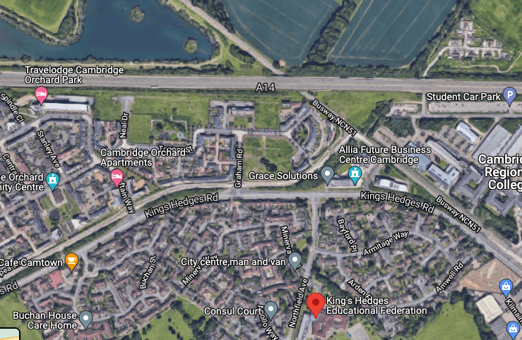
Above – from G-Maps here. Even if the fields at the top of the photograph were turned into open parkland, pedestrians and cyclists face too many substantial obstacles to make regular use of it.
Which brings us back to Charlotte Stuart’s proposals which, as well as having Ecoducts (I like that word), as and when the housing stock comes towards the end of its life, some of the land that housing occupies will have to be converted into green space, and some will have to be turned from lower density to medium density housing to compensate. That may also require the provision of allotment land if future generations are not able to have their own back gardens. But it can be done – and Cambridge has demonstrated how.
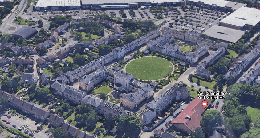
Above – From G-Maps here, St Matthew’s Gardens.
Built on the old PYE Factory site round the back of the Beehive Centre – named so by the Cambridge and District Co-operative Society (now defunct having sadly bet the basket of eggs, or rather the beehive on it being a money spinner and losing), I know a couple of people who live around here and design-wise this works for me. One of the principles they’ve gone with is with much smaller back gardens in return for larger shared open space – which is the opposite of many of the post-war housing estates.
The point remains that the systems of town planning and transport planning are not resulting in the new neighbourhoods that enough open green spaces, easy access to the countryside through active transport, a public transport service that means people don’t have to rely on cars, and sufficient community facilities to make the places pleasant spaces to live in. Being strapped into the international property markets means that some people are making a lot of money out of the current state of things. Hence I remain of the view that many of the root causes of these problems are found in Westminster.
If you are interested in the longer term future of Cambridge, and on what happens at the local democracy meetings where decisions are made, feel free to:
- Follow me on Twitter
- Like my Facebook page
- Consider a small subscription to help fund my continued research and reporting on local democracy in and around Cambridge.