Either way questions remain over the lack of a comprehensive public transport plan to get affluent workers moving into the area out of their cars. What could our collective long term transport response include?
I spotted this in very late 2022.
…and it has since caught the attention of Cambs Live.
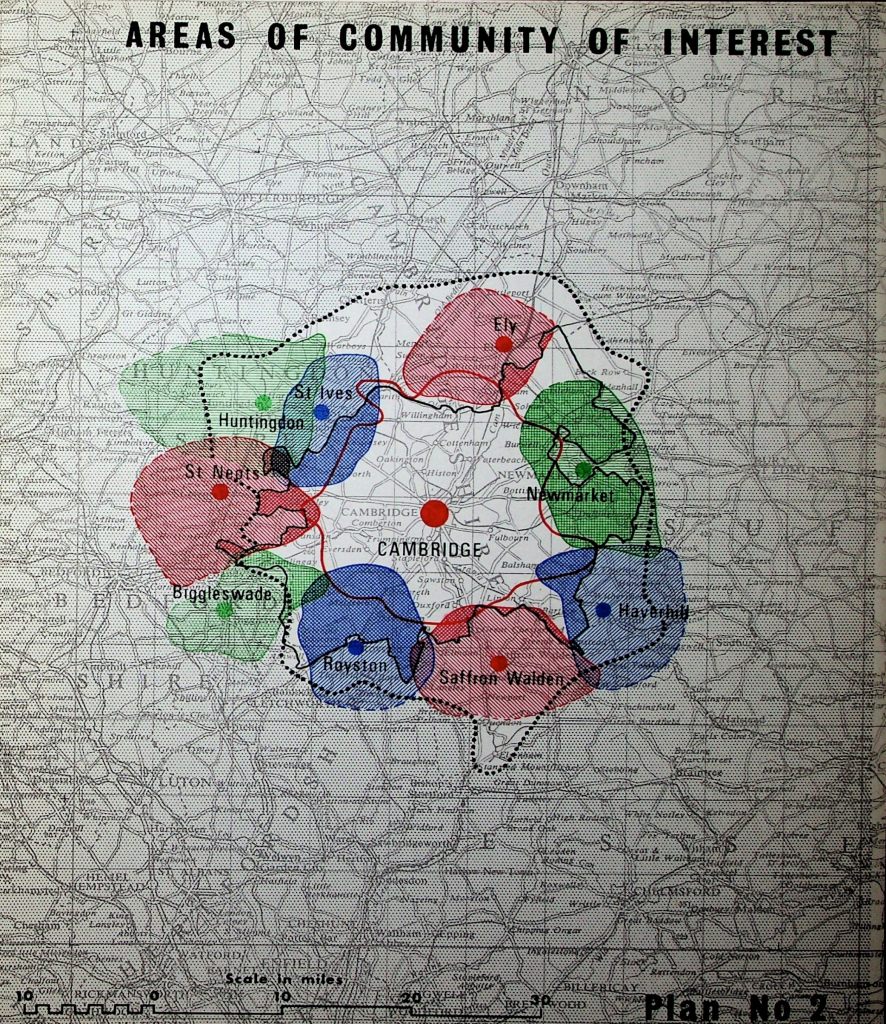
I covered some of the issues in this previous blogpost on what Gordon Brown’s Government came up with on their East of England Plan in 2008. This matters in the case of the existing Melbourn Science Park near Royston because the EoE Plan 2008 (which you can read here) states:
“The Cambridge sub-region comprises Cambridge and the surrounding area as far as and including the market towns of Chatteris, Ely, Haverhill, Huntingdon, Newmarket, Royston, St Neots, St Ives and Saffron Walden.”
EoEP 2008 13.6
Note this is different from what Greater Cambridge is – effectively Cambridge City on its 1935-era boundaries, plus 1974-era South Cambridgeshire.
“Is anyone counting all of the science park developments and asking how they can all be linked up through electrified public transport?”
Ditto linking them to residential areas and leisure sites.
I’ve called for the science park owners and companies to make substantial contributions towards a light rail network – see this regarding Fulbourn where a planning inspector overturned the original refusal by local councils. Furthermore, I said the same thing about developers and their bids for the emerging Greater Cambridge Local Plan 2031-40 in this blogpost of May 2021.
Former transport minister Norman Baker – now of the Campaign for Better Transport, has a plan
You can read it here. (Liberal Democrats, he’s still one of your party members!) I write this because several local councillors are on first name terms with him and should be making the case to get some concrete (or steel-rail) proposals into their party’s manifesto for the next general election.
“Could a South-West Cambridgeshire Light Rail Loop work?”
I had a play-around with G-Maps here, using the cycling journey option. Having never been a regular car driver since I passed my driving test in late 1997, in my mind I’ve always pictured accessibility in relation to public transport and cycling maps. Therefore the idea of getting to Duxford IWM to Royston as a concept is completely unknown to me.

Above – SW Cambs light-rail loop that would ultimately link up to any Cambourne-Cambridge route.
When we look closer at linking Duxford to Royston along the A505, a few interesting things arise.

The long diagonal blue line is the A505 which, if it had a light rail & cycleway built alongside it, would create a straight-forward public transport link from the Hertfordshire towns south of Royston (i.e. Baldock, Letchworth, Hitchin, and Stevenage) to the Imperial War Museum at Duxford.
“Ploughing a tram-train through Royston town centre? Good luck with that one!”
That’s one option – but I couldn’t see it happening in the current political climate. The other option is to have such a light rail providing a southern bypass for Royston while at the same time connecting a host of services that are located on the edge of the town.

From IWM Duxford via Heydon Grange, one alternative would have a south circular route spurring off the A505 northern bypass and serving Royston Hospital (note the local MP’s campaign on this) but not going through town as illustrated above. That loop would continue round to:
- serve Royston Rugby Club and
- Therfield Heath Car Park (the start of a popular walking spot)…then loop around (and even occupy one of the dual carriageways) along the A505 to…
- serve both the industrial estate and Tesco (opportunity for light rail/rail freight/freight exchange?) then…
- move onto the Science Park at Melbourn and linking up at either Meldreth or Shepreth, then on to…
- Cambourne via Wimpole Hall & Bourn, then finally onto Cambridge.
Furthermore, in a future phase there’s nothing to stop an additional option bypassing Royston and having some services going from Heydon Grange straight to Melbourn Science Park.
“Sounds Crazy! Too Expensive!!! Can’t Be Done!!!”
Over the next decade or so, perhaps. Over the next 30 years? Let’s look at Cambridge and the districts around it back in the late 1950s.
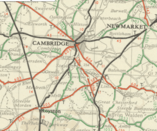
Above – from the National Library of Scotland’s maps
Note the lack of an A14 dual carriageway. They were still arguing over the traffic that ploughed through the city along the old A45 over both Victoria Avenue Bridge and Magdalene Bridge – the original ‘Bridge over the River Cam’ that gives Cambridge its name. All the regional traffic had nowhere else to go. On top of that, all of the traffic coming down the A604 – Hills Road and Huntingdon Road had to use the same bridges. No M11 to bypass the traffic around the city centre.
Compare that to today

Above – by 1990 the M11, A14 (still the A45 back then) and the A11 dualling had largely been completed, creating a series of bypasses around Cambridge. Or ‘the triangle of doom’ where you cannot escape the background noise of roaring traffic!!! But hey, at least it’s over there and not clogging up our city centre, right? Or has traffic gotten worse as road building programmes expanded to compensate?
The post-WWII / late 20th Century road building projects were significant and expensive
Yet the expense didn’t seem to put off ministers from approving the upgrades any more than the A14 upgrade around Huntingdon – which according to New Civil Engineer cost £1.5billion. Nice money if you can get it. Yet as I’ve mentioned before, the model that provides the context is nearly a century old. Below centre of the three images is Thomas Sharp’s model from 1931 in Town and Countryside. (You can read it here). Below-left is the Redcliffe-Maud proposal for a Greater Cambridge Unitary Council from 1969 (and adopted by Harold Wilson’s Government in 1969) – abandoned after Labour lost the 1970 General Election. And below-right, Nathaniel Lichfield explored the issues in 1965


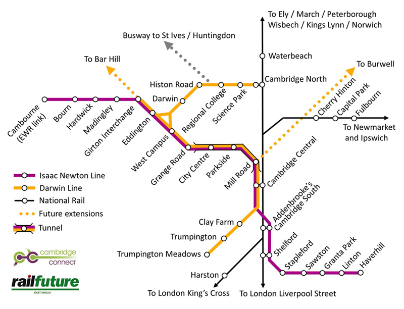
Above – the latest proposals from Rail Future East (Join their campaign here/tell a rail commuter about them) and Cambridge Connect – incorporating re-opened stations for Cherry Hinton, Capital Park, and Fulbourn, along with confirmation of Cambridge South’s approval, and Cambourne’s East-West-Rail link.
The ‘light rail loops’ concept
I’ve mentioned this numerous times in previous blogposts. Over the next half-century I think Cambridge should be building such a network if ministers intend on the region’s economy to grow. In this case below, as well as having a Cambourne-Cambridge-Haverhill line, an extension to Saffron Walden then back up to IWM Duxford, Sawston, Addenbrooke’s and Cambridge creates a potential ‘loop’ service in addition to the Isaac Newton Line.

Above – illustrating the short distance potentially under 15 miles) from Haverhill to Saffron Walden
The loop back from Saffron Walden into Cambridge would use part of the line between Cambridge and IWM Duxford – which then becomes an interchange/transport hub for two lines and local bus services. As a result it becomes a site that firms will choose to locate.
The same goes for Meldreth and/or Shepreth with an interchange between the main railway line and a light rail. Inevitably for the latter this will require sound insulation works but it is not impossible.
Finally the link up to Wimpole Hall (lovely place – awful to get to by public transport) and Cambourne with the East-West-Rail line creates new options for people to get to by public transport and opens up Wimpole Hall, Shepreth Wildlife Park, and the Imperial War Museum at Duxford to tens of thousands of people coming by public transport who might otherwise never visit.
But it won’t happen unless…
“Unless what?”
Unless a critical mass of us do things that we would not normally do. On this occasion rather than the Write to your MP/councillor!!! exhortations I make every so often, try either one of the two below:
The first is: Buy a book on politics – not one aimed at adults, but for children. Eg Politics for Beginners. I found a copy in Waterstones in Cambridge. You can find one in local children’s bookshops (there’s even a box set!) or if you’re stretched for cash, buy a second-hand copy. And when you’re done reading/browsing, either give it to someone (ideally younger than you) or donate it to a local charity shop.


Above-right – join the Light Rail Transit Association and you get a monthly magazine on the sort of light rail and tram systems other places are getting that we are not.
Again, if you are strapped for cash as many of us will be both at this time of year and in the current cost of living crisis, get hold of a back issue online second hand that looks like it has an interesting headline and get a sense of what the issues are. (And then donate it to a charity shop, or pass onto someone who complains about traffic a lot!)
Still lots to ponder over.
If you are interested in the longer term future of Cambridge, and on what happens at the local democracy meetings where decisions are made, feel free to:
- Follow me on Twitter
- Like my Facebook page
- Consider a small donation to help fund my continued research and reporting on local democracy in and around Cambridge.
