The long-running proposals to revelop the site of the old tip and cement works comes back again. Building a sci/tech development on an old landfill site (by sinking thick metal piles into the bedrock and building a frame over the landfill site, rather than resting on it) is a huge undertaking.
You can read the 397 documents here – many of which contain files of multiple pages. Such as the Design and Access Statement which has been broken up only the file goes into over 250 pages.
TD/DR?
Browse through:
- The Planning Statement here: This has lots of words and a few pictures in, and amongst other things tells the story of ‘how we got to here’ with the site. I.e. it takes the reader through all of the previous activities that have happened up until now. It then describes what the final development should look like on completion. Just without the pictures – which are included in the document below. Look out for heading 6.2 Development Plan (from p36 of the PDF). The question to ask yourself is: Have the developers met the requirements of each part of the Cambridge Local Plan 2018? Conveniently they state what each part is. If you think they have not, and can provide evidence to show this, you can object to the planning application.
- the Design Principles document here. This picks out the things to look out for if you want to see what the end result should look like (illustrative documents) and what things the developers say they will work to – including things in planning and environmental law that compels them to work within. (Control documents).

The advert shows the area the development is proposed for below.

“Above: What is that in Plain English?”
Only some people online have understandably complained that the above notice is incomprehensible to the general public. A general point: If you’ve got something in Latin that needs explaining, you’ve already failed on basic communication with the public. (Note that this is an issue for central government to resolve – local town planning teams will (quite understandably) say that they have to comply with planning law).
Land South of Coldham’s Lane…sounds familiar.
Local historians might be familiar with the old cement works off Coldham’s Lane below.
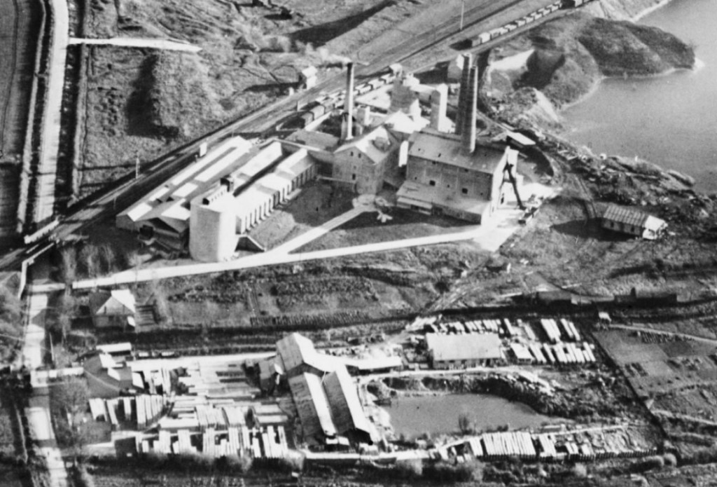
Above – from EPW025477 – Cambridge 1928 from Britain from Above – a detail of Coldham’s Lane (the road on the left running top to bottom) with the familiar railway bridge that a lorry crashed into recently.
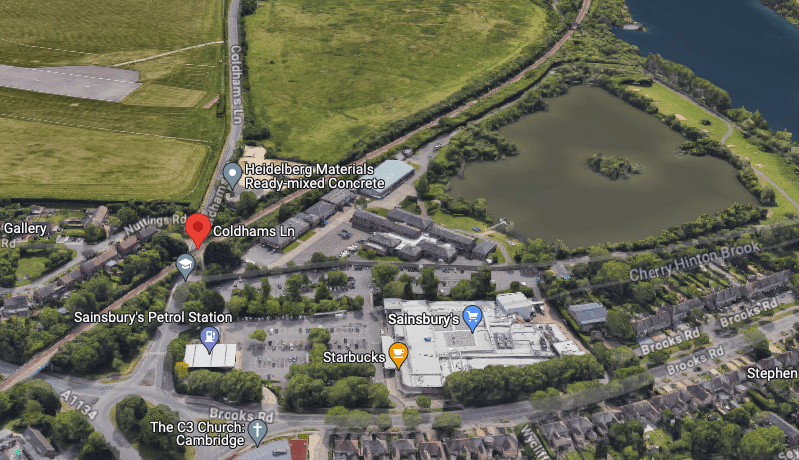
Above – the same view from GMaps more recently
That is at the very western end of the site. Further along (eastwards, so moving upwards on the picture above) is another old cement works site whose chimney’s dominated the landscape until the site was flattened, taking the chimney with it.
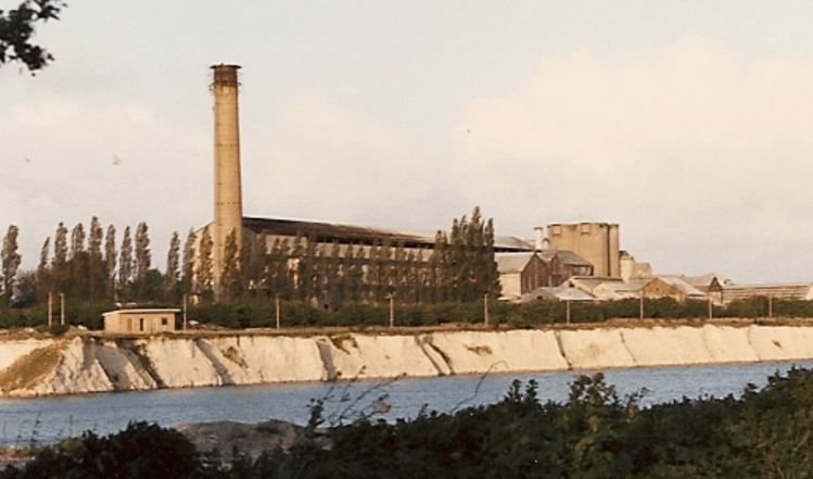
Above – by Geoff Kitchin on CCAN here – the disused cement works from the late 1980s
(You can read more about the history of Cherry Hinton Village on the CCAN website here. Furthermore, the Victoria County History entry is here. And finally you can join the Cherry Hinton Local History Society here.)
Cherry Hinton Residents grill the developers – March 2023
I went along to two consultations for this:
- the consultation at the old Cherry Hinton Library (now closed for redevelopment) back in March – see my write-up here.
- the June 2023 event where the developers presented their first ideas – see my write-up here.
Hence there will be some things that are familiar from that consultation, such as the broad plan that they showed in the summer below.
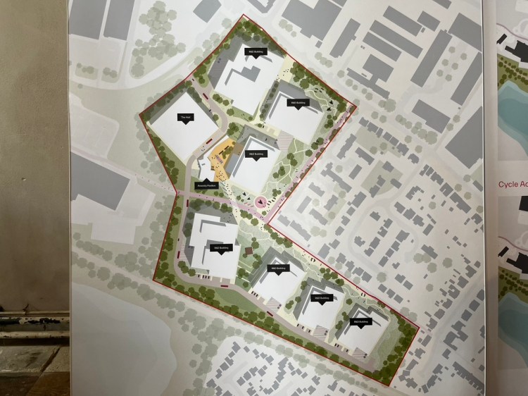
Above – from the consultation in June at St Andrew’s Church, Cherry Hinton, Cambridge
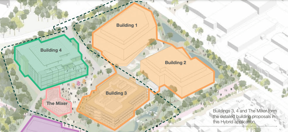
In the design principles document you get things that set out their aims

Above – p13 of Design Principles
The Mixer – an amenity pavilion
I’m particularly interested in this because of the area’s lack of community facilities.
Above – p31 of the Design Principles
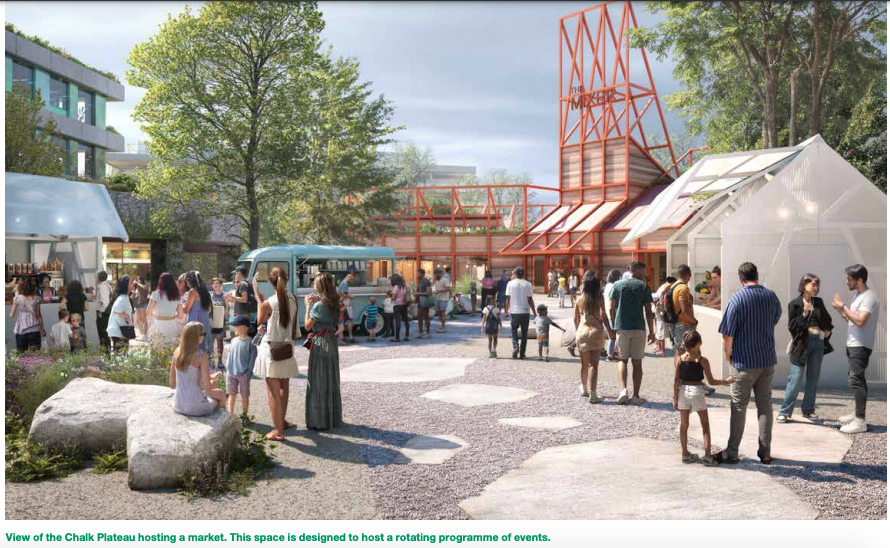
Above – “The Mixer” in the background – the rust-coloured building. From the second Design and Access file (03 – 04) here

Above – from the Design Principles file p40 – there’d better be polka dots on the roof of building 5!!!
Building on an old landfill site
The Mill Road History Project had a look at and produced a report on the pits that were created as a result of quarrying. You can read about it here.
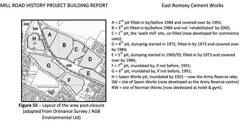
Above – Capturing Cambridge – report by Mill Road History Society on East Romsey Lakes.
The view looking southwards on the current site (so on the top-right of the above image looking bottom-leftwards) is in the screengrab below

Above – from G-Maps here
That green patch covers a whole host of historical naughtiness as it’s one of the old landfull sites from the days when the dumping of waste wasn’t really controlled. So it has been capped and forgotten about. The general principle about disturbing such things was set out on 1980s Children’s TV with The Trap Door.
Above – Trap Door. Best left closed
“The quarry was backfilled with a mixture of household, commercial and industrial waste materials between the late 1960’s and the early 1970’s.”
Planning Statement p12 of the PDF
Travel-to-work plan and Transport Assessment
My biggest criticism of the development is the lack of a light rail stop that could serve either the Beehive Centre redevelopment by RailPen, and/or this one off Coldham’s Lane by Mission Street
Hence both have mentioned Cambridge Railway Station as the main station for their potential site workforce. Looking at G-Maps here, you can see the proposed cycle route it automatically generates – using the Travis Perkins site as a proxy.
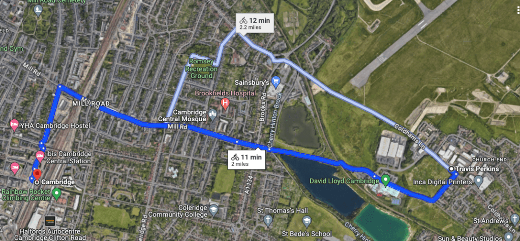
Above – from GMaps – cycle route from Coldham’s Lane entrance to Cambridge’s main and already over-crowded railway station
“The route from the Application Site to Cambridge Railway station is considered to be of a good standard with a largely off-road route for pedestrians, cyclists and micro-mobility users to access the station within a 10-minute cycle or 30 minute walk.”
Para 5.23, Transport Assessment file 1-49
“Is considered to be a good standard…” by whom exactly?!?
Only I think it’s cr*p and I’ve cycled it more than a few times over the decades. There is an option to build a cycleway between the site and the Cambridge-Newmarket Rail Junction (where I filmed this short video explaining the case for a light rail station) that would benefit from not having any major interruptions before joining the Chisholm Trail cycleway, linking to both Cambridge North and Cambridge Stations.
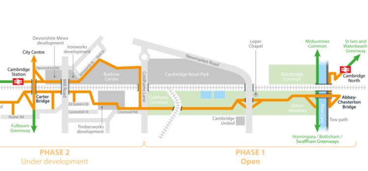
Above – the Chisholm Trail Phase 2 under development, from the Greater Cambridge Partnership, which the Mayor of the Combined Authority had a look at with Jim Chisholm and CamCycle in Sept 2023 here
Reducing the impact on Cambridge Railway Station
Until a light rail stop is built for those two developments as part of a wider network eg Cambridge Connect Light Rail, something that would require a longer term party political agreement that is strangely lacking, the only option to reduce station overcrowding is the century-long-delayed eastern entrance to Cambridge Station. This was something I looked at in June 2022 in relation to a local planning application – it was the Holford-Wright Report that reminded a previous generation of the need to get that eastern entrance built.
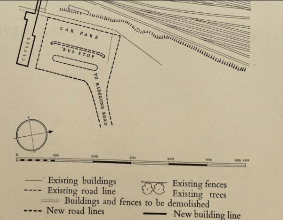
Above – from Holford & Wright 1950 – feel free to explore their maps via Lost Cambridge here.
A proposed Eastern Entrance to Cambridge Railway Station is also something Rail Future have lobbied for more recently. See Edward Leigh’s article for Rail Future East Anglia from Sept 2022 here from p15 onwards
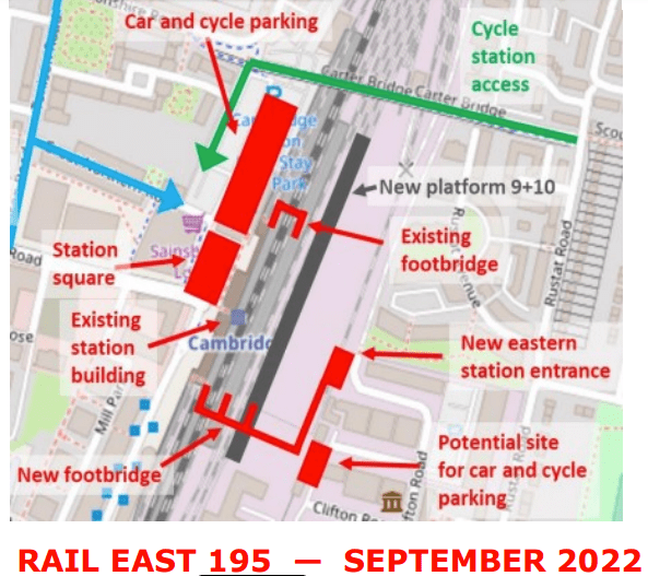
If council planners and planning committee members are strong enough and sensible enough, they’ll insist on a contribution towards the cost of an eastern entrance to the railway station – and possibly a subsidy towards the 114 Bus Service that could be re-routed to provide a bus link between the Eastern Entrance and the new development via Davy Road, Coleridge Road, Mill Road, Brookes Road, Coldham’s Lane, and looping back down Barnwell Road to serve Abbey Ward.
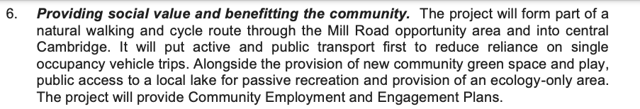
Providing social value and benefitting the community
The outline planning statement on p11 of the PDF provides some useful supporting text for such a move.
Instead of scheduling their own shuttle buses, it would make more sense for the development to subsidise an existing service (that Cambridge City Council already subsidises) to increase significantly the frequency of the service and to pay for electric buses to do the shuttling rather than old cheapo diesel ones.
It should not be left to Section 106 / Community Infrastructure Levy agreements – which places all of the costs burden on the new investment without making the firms already here and potentially benefiting (Especially financially) not making their own contributions through the tax system.
You can comment on the planning application via the guidance here. Note the planning reference for this application is 23/04590/OUT.
Feel free to share this to anyone interested. The more scrutiny (and the more informed that scrutiny is) the better. Note the guidance, in particular:
“We can only take into account comments on certain matters. These include:
- Design, appearance, and materials
- Loss of light or overshadowing
- Parking, highway safety, traffic and public rights of way
- Noise, fumes and smell
- Effect on listed building and conservation area
- Nature conservation
See the more detailed Material Considerations by the GCSP Service here
Failing that, I can run a town planning crash course like I did at Rock Road last November, with a focus on how the basics of the planning system apply to this case.
Food for thought?
If you found this useful and are interested in the longer term future of Cambridge, and on what happens at the local democracy meetings where decisions are made, feel free to:
- Follow me on Twitter
- Like my Facebook page
- Consider a small donation to help fund my continued research and reporting on local democracy in and around Cambridge.
