
This follows Cambridge Connect and Josh Grantham’s one for the Cambridgeshire Sustainable Travel Alliance
Image – Rail Future East’s annual meeting in Cambridge (which always clashes with the Mill Road Winter Fair!) – do come along and talk trains, trams, light rail, and integrated public transport and active travel!
Once you put a map in front of people, the conversations change. In my experience anyway.
Here’s Cambridge Connect – the original and still the one I think we should be starting with
Above – a geographical interpretation of Dr Colin Harris’s proposals
Then there is Josh Grantham’s tram-orbital which I also quite like and wrote about here, because it deals with those otherwise over-complicated journeys to venues over the other side of the river. It takes over an hour to get to Cambridge Regional College from south east Cambridge. Which perversely has meant generations of teenagers from working class backgrounds have had longer and more expensive journeys to college compared with their generally middle-class ex-school mates who went to Hills Road or Long Road Sixth Form Colleges.

Above – Cambs Sustainable Travel Alliance (2025)
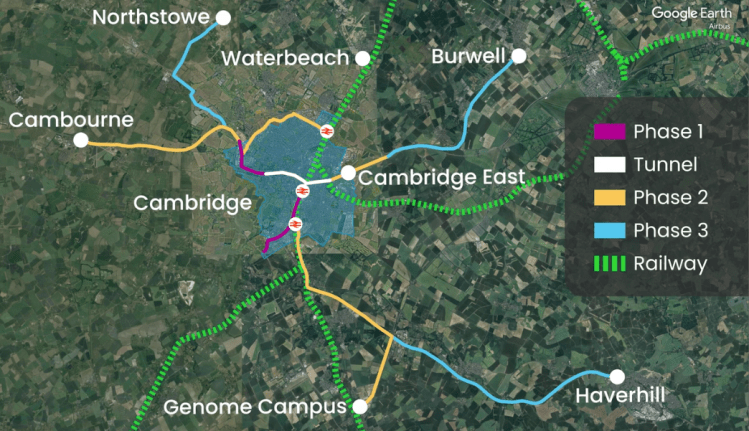
Next up, Andrey Afonin of Steer

Above – you can read Andrey’s post here and zoom into the diagram more clearly than in my blogpost
Again, I quite like the proposals – mindful that petrol and diesel fuelled cars will have to be phased out and soon.
“Phasing out the sale of new petrol and diesel cars from 2030 and support for zero emission vehicle (ZEV) transition”
Above – detail of Mr Afonin’s map
The part of Cambridge that his proposals miss are the wards of Coleridge and Cherry Hinton. This needs rectifying given the population demographic of both wards, which contain sizeable cohorts of council housing and older residents. More than a few of those older residents are people who have lived in their neighbourhoods for decades, and whose now grown-up children went to local primary and secondary schools. Additionally, Cherry Hinton has seen some significant densification of council housing around the library and hub on the High Street.
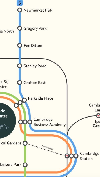
The change I propose for the blue No.5 line from Newmarket Road P&R
The line as it stands proposes going straight from Cambridge main railway station to Clay Farm – presumably via the southern guided busway. Instead of doing that I propose the at the line serves the confirmed and long overdue Eastern Entrance to Cambridge Station – thus taking the line down Hills Road until the junction at Cherry Hinton Road – as proposed in 1899 with the abandoned extension of the Horse Drawn Tram.

Above – the proposed extension to the horse-drawn trams in 1899 which ran from the station to the city centre. You can read about the proposed extension, proposed electrification, and ultimately the failure of our tram system in Lost Cambridge here.
With the Cambridge Leisure Park submitted for comprehensive redevelopment in the emerging local plan along with the Clifton Road Industrial Estate, I propose the tram line heads down a re-aligned Clifton Road to get to the proposed Eastern Entrance (shown as Rustat Road for illustrated purposes below).

Note there is enough flexibility in this route to respond to emerging development proposals and deal with existing passenger demand from private commuter buses, including:
- The inevitable densification of the Lichfield Road estate which I wrote about in 2021 here.
- The redevelopment of The Paddocks off Cherry Hinton Road which got planning approval
- Any diversions needed to serve Peterhouse Technology Park – could they £contribute towards new transport infrastructure?
- The new housing on the old Ida Darwin site
- Any extension into Fulbourn Village that the residents may want – noting that one alternative is to loop the tram track around the village instead of passing in front of it.
- Capital Park (again could they £contribute?) and an interchange with a new Fulbourn suburban station
- Fulbourn Tesco (reducing dependency on the motor car)
- Any potential housing development east of Gazelle Way – I would not be surprised if the Cambridge Growth Company mandated additional housing development on top of what’s in the local plan.
- The existing housing being built at Springstead east of the airport
- Any development on the airport site (and a potential interchange with Cambridge East Station)
- Any link to Teversham Village
- Using the Ice Rink or the proposed GCP Park and Ride east of Teversham as a terminus for both ends of the line

Above – Lichfield Road council flats (looking westwards) in the middle of the square of inter-war semi-detached cottages
The site was previously an estate of post-war pre-fabs

Above -From the Cambridge Daily News 18th Oct 1946 via the Cambridgeshire Collection – the same estate looking southwards.

Above – from G-Maps. The tram line can either pass the western end of Fulbourn Village or loop around the village entirely, potentially making it more accessible for residents.
Anyway, have another look at Mr Afonin’s article again and think about getting involved with Rail Future East – especially if you are already a regular rail traveller.
If you are interested in the longer term future of Cambridge, and on what happens at the local democracy meetings where decisions are made, feel free to:
- Follow me on BSky
- Spot me on LinkedIn
- Like my Facebook page
- Consider a small donation to help fund my continued research and reporting on local democracy in and around Cambridge.

