How does one of Cambridge’s lower-profile wards look a year after some of us gathered on a cold January evening to discuss a council survey of the ward? (Unlike today which was the warmest day of the year and saw dozens of people on Coleridge Rec enjoying the sunshine after lockdown and a bitterly cold winter).
You can read the survey results here. Shortly after the meeting at Lichfield Hall (did you even know it existed?) I wrote up a blogpost of the meeting.
The outreach work had more than a few challenges.
“The youth survey failed to gain traction. Approaches to Ridgefield Primary school and local cubs/scouts were unsuccessful. Surveys left with Romsey Mill did not engage the young people using their services. Most questions had free text answer. These answers have been analysed and grouped together by category and subcategory in this report to help establish patterns and trends.”
Coleridge Ward survey, Cambridge City Council 2019, p4.
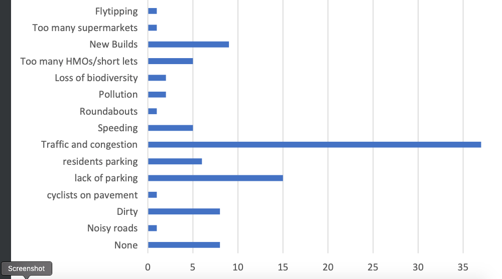
Which tells me that if the council is to carry out a post-CV19 survey of the ward – one I think needs doing for every ward in the city, it will have to rethink its approach. Only 124 people responded to that survey. Hence there’s only so much one can read into the responses. Of all of the issues raised, traffic and congestion was by far the highest.
On The Junction and The Folk Festival
“The findings I didn’t expect were the low scores for The Junction and the Folk Festival. People said that neither had sent them publicity for tickets or invitations to community events even though they were on their doorstep.”
Blogging just after the meeting on 21 Jan 2020.
Something that has to be part of the local recovery plan for both venue and festival respectively has to be a local marketing & engagement strategy. I.e with people in the local neighbourhood and something that is not a one-directional relationship between a buyer of tickets and a seller of tickets. At the same time it needs to recognise that people in the local neighbourhood are the ones most able to decide at the last minute if they can attend an event that is within walking distance of where they live. In the longer term once it re-opens, The Junction should be looking at reducing the number of unsold tickets there are for its events through marketing to neighbourhood audiences in the days before an event takes place.
On neighbourhood community centres and housing density
I wrote here about how post-war housing estates in Cambridge lacked community facilities, to the extent that residents who had been moved out of the slums and over-crowded central areas complained bitterly. Coleridge and Queen Edith’s are classic examples of postwar housing estates built at low densities with limited communal and community facilities. With such high land and house prices, this has created a new incentive for predatory developers to buy single dwelling detached properties with large gardens, and break them up into smaller developments of flats. That or simply banking the planning uplift and selling on the property to a different developer who pleads poverty over any social housing element or community infrastructure requirement. It’s a loophole that successive Conservative housing ministers have chosen not to do anything about. (“Advisers advise, ministers decide”).
Neither wards have purpose-built community centres. One could argue that until very recently, neither had the population density to sustain one.

Above – Coleridge and Queen Edith’s wards are effectively hemmed in by the main roads that the commuter motor traffic uses. Queen Edith’s is effectively the neighbourhood south of Cherry Hinton Road, and Coleridge is the ward north of it until you get close to Mill Road, at which point you hit the People’s Republic of Romsey Town – one of the neighbourhoods that has a very strong historical local identity. (They even have a t-shirt).
“Why the low-density neighbourhoods?”
If you took a walk through Eglantyne Jebb’s Cambridge you would not find row-upon-row of semi-detached homes built to a uniform design as in the 1920s. The mass-produced cottage design is replicated across the country. Before the war, Cambridge’s working class neighbourhoods were interspersed with a variety of building types – workshops, breweries, pubs, shops, mission halls, chapels and club rooms. Public drunkenness and poor sanitation & poor public health were all big killers and major social problems.
Under the “homes fit for heroes” slogans, the post-war housing had more space than the Victorian terraces, and were planned with larger front and back gardens, and also set back further from the street. If you start at the western end of Cherry Hinton Road the oldest homes are the ones closes to the road. As you walk down the hill the houses become set further and further back from the road – at three specific points, reflecting the changing planning rules.
There were far fewer communal facilities – between the two wards there are just a handful of public houses. The Rock Estate – “New CherryHinton” as it was first known as, had what are now The Rock & The Rathmore – the latter formerly a Liberal Club. Coleridge had what I still call The Master Mariner (now The Dumpling Tree) on Perne Road. And post-war Queen Edith’s had… The Queen Edith until it closed and was redeveloped & is now operated by the Milton Brewery. Each major extension of housing was accompanied by an Anglican and a non-conformist religious institution. Some have fared better than others, but the former New Cherry Hinton Free Church – later the United Reformed Church on Hartington Grove, was closed and sold off to the Greek Orthodox Church.
If the housing density is to increase, it has to be part of a planned and resourced scheme. Otherwise the risk is the neighbourhoods end up with an increase in the population without the community facilities needed to serve them.
This is one of the patterns of development that has irritated more than a few residents – even more so when developments are put together so that they are just under the requirements for social housing contributions, community infrastructure contributions and so forth.
Several years ago the Liberal Democrats, when they controlled the City Council put together a plan to overhaul and redevelop the Lichfield Road flats – home to mainly elderly residents in council/social housing. Below – the Lichfield Rd flats looking westward, with Perne Road along the bottom of the picture. Lichfield Park (I’ve always known it as Neville Rd Rec) is where I sometimes film lockdown video monologues – when the place is not taped up!
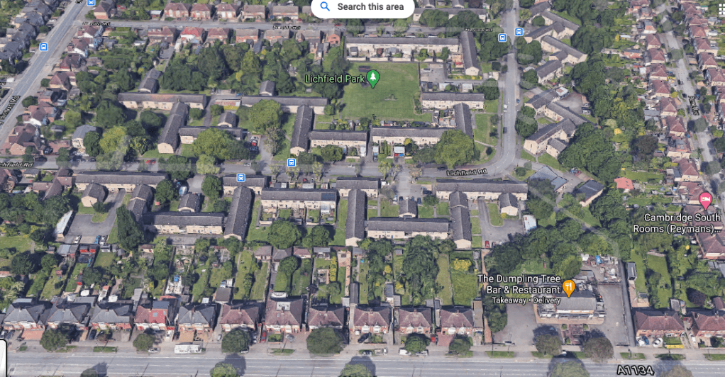
The scheme fell through in the face of local opposition, and then Labour taking control of the council having made a commitment to shelve the plans. In the grand scheme of things the site in the longer term will need an overhaul – not least because the flats are showing their age. Should that happen over the next 20-30 years, the site of The Dumpling Tree pub/restaurant along with the small Lichfield Hall behind it (the two flat-ish roofed low-level buildings hidden by the trees) could be turned into a much larger community venue over two-three storeys incorporating a large hall that the neighbourhood currently lacks.
“20-30 years – that’s a long time in the future”
But it’s the time frame we need to be thinking about given the hit we’ve started taking due to the climate emergency. I’m also aware that I may not be around at the latter end of that time frame. But when you’re doing the very long term urban planning, you’re not doing it for yourself. The first demand for a park in what became Coleridge Ward was as early as 1912 – from the Cambridgeshire Collection below.
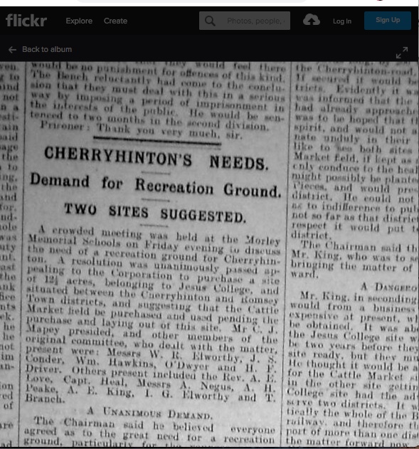
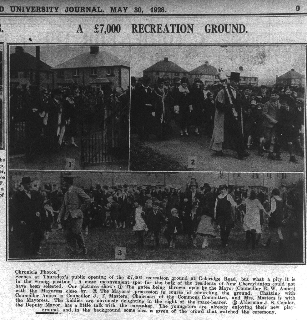
The meeting took place at Morley School, appealing for the Corporation of Cambridge (i.e. the City Council) to buy some of the land that was owned and being developed by Jesus College, to become open park land. In 1928, the park was opened.
A year later up the road, the Romsey Labour Club opened, ….and just under decade later, the secondary school down the road, Coleridge Secondary, opened.

Above – The Mayor of Cambridge Bill Briggs, the first Labour Mayor of Cambridge in what was otherwise a safe-as-castles Conservative borough, opened the school.

Above – Bill Briggs in the Cambridge Independent, 13 Nov 1936, via the Cambs Collection.
Sadly that run of community building construction did not last, and Coleridge School struggled for many years until it became part of a partnership a decade or so ago. When I visited on its open day it was clear that under its new leadership at the time it had more than turned a corner – and that deserved recognition as I wrote here.
Rebuilding after Covid19 – “Build Bridges”
The late Mayor of Cambridge Nigel Gawthrope told the great and the good that he wanted them to build bridges between communities across Cambridge. This should be the theme of rebuilding our communities and our city. Because I don’t think we’ve appreciated the collective hit that we’ve taken – over 100 people have died due to the pandemic, many businesses have folded, and big brand name shops have imploded, never to return – such as Debenhams in The Grafton Centre. What is to become of it?
“Societies fairs across the city”
…is what I wrote in this earlier blogpost. I think The Junction in Cambridge should host one for the whole of the south of the city. The school or even Coleridge Rec with a temporary marquee could host a summer event (mindful how these can get washed out – as Cherry Hinton’s summer festival found out on more than one occasion). These events should be opportunities for councils and community groups to find out what local resident not only want from the rebuilding process, but what they are willing and able to contribute to it as well, in terms of time, skills, resources, and financially.
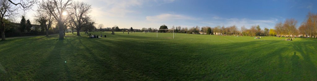
Because the people are there – I saw over 100 of them at Coleridge Rec today on the first really warm day of the year. (Most of them were out of sight by the playground and the ice cream van at the other end of the park). They just need to be invited.
Which reminds me – don’t forget the Cambridge Concert Hall petition!
