And if so, how does it go about acquiring such space in the expensive low-density suburbs that have little spare land going?
It turns out that the call for better primary school buildings, playgrounds, and green spaces is not a new demand at all. As far as party political manifestos go, you can go back to at least 1945 with the Cambridge Communist Party (yes, we had one) demanding such improvements in a very detailed manifesto for the local elections of 1945. You can read the manifesto here.
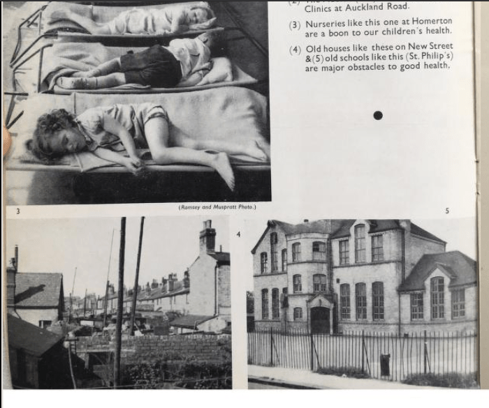
Above – praising Homerton Nursery School (which was built on a single floor) vs the old multi-level St Phillips School, long since demolished and the school relocated, as explained by Michael Rosen here.
There are still a number of state primary schools that don’t have their own open green spaces, including the current St Phillips, Morley, and St Matthew’s – all south of the river (you can search on Gmaps here) and all of which date back to before WWI in South Cambridge. It’s worth noting that until WWI, Cambridge City Council’s boundaries were much smaller.
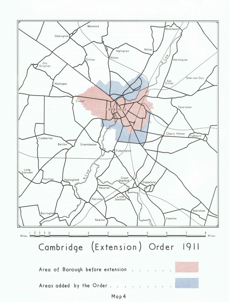
Above – any schools built in the northern blue patch before 1911 under the powers of the Education Act 1870 as amended, would have fallen under the remit of Chesterton Urban District Council.
Schools without playgrounds is not a new phenomenon sadly. If we go back to the 1880s and look at some old maps, we can see that Victorian Cambridge was full of rooms and inadequate buildings used as schools.

Above – from this map from the National Library of Scotland, turn of the century Cambridge in exquisite detail. The Eden Street School and the Paradise Street School (in the then notorious slum of The Kite where firebrand preacher and social reformer Ellice Hopkins started her work) no longer exist.
In more recent times, more primary schools have closed, replaced by flats, social/sheltered housing or alternative provision. Romsey and Coleridge in Cambridge lost Romsey Infants School, Romsey Junior School (where Ruth Bagnall Court is), and the Sedley Taylor Infants School – where the Patacake Day Nursery is.

Above – there used to be three schools in this screengrab. Not today.
“But cities change and evolve – as do the people within them. We’re an ageing society so we cannot keep all of the old buildings as museum pieces”
True – and it also means some very difficult decisions ahead for whichever council ends up being in charge of schools. One of the drawbacks of Michael Gove’s reforms and centralisation of his academies scheme is it makes it much harder for resource-starved councils to plan and co-ordinate what to do in the future. One of the many shortcomings of the fragmentation and outsourcing of the public sector: you lose that co-ordination because no one is under any duty to co-operate. Note there are still some who advocate a system where all parents are given a ‘voucher’ which they then allocate to their chosen school, and the ones that get the most vouchers get the most funding for places. The stronger schools expand, the weaker ones shrivel and close. A policy that has so many assumptions that are unworkable in real life – such as an infinite supply of land to expand onto, and no time lags to build new classrooms or recruit new top rate teachers who are in high supply because the housing crisis has been assumed away.
The re-sited St. Phillips illustrates the planning challenge – and also one of the opportunities post-2030
You can see the school site on the left, and the airport site on the right, with Sainsbury’s just below it.

On a good day, the roundabout in the middle has a queue of traffic around it. On a bad day, that queue of traffic hardly moves. This was part of the planned Eastern Ring Road that was supposed to incorporate a major viaduct over the River Cam linking it to Milton Road. But residents threatened a revolt and Holford-Wright’s plan was dropped.
Cambridge architecture researcher Charlotte Stuart in her radical presentation to the Cambridge Commons (I’ll ask them for the video) came up with some solutions using North Cambridge as her case study. In particular her research and proposals involve pedestrian priorities and a series of new bridges over existing busy transport corridors. Cambridge community and campaign groups, you can get in touch with her here.
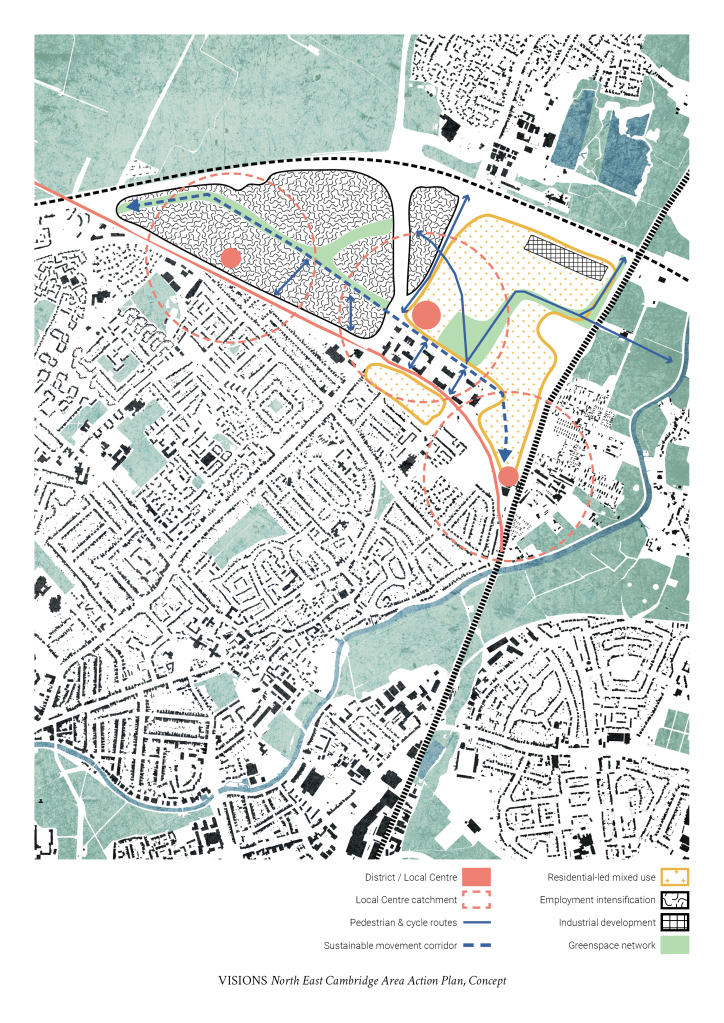
Above – from Charlotte Stuart here, her outline proposals to break the isolation of the Science Park site, currently walled in by the A14, Milton Road, and the Guided Busway.
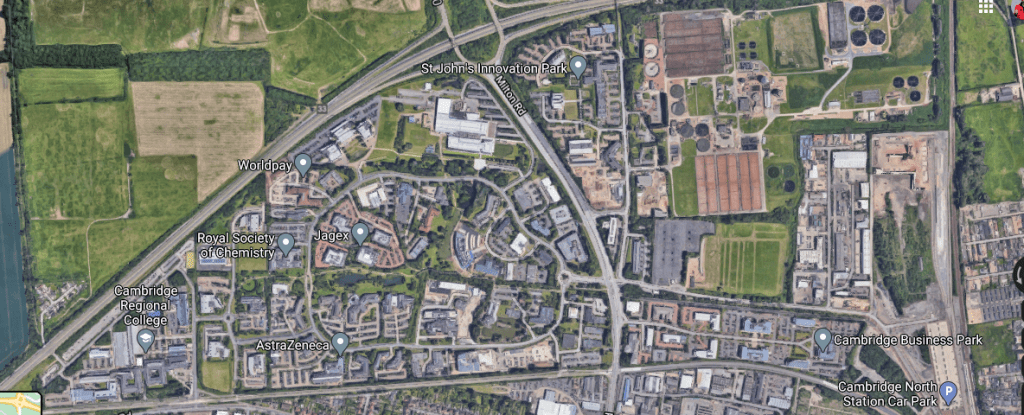
Above – the Science Park from GMaps above.
One of the challenges is how to do this with a minimal climate footprint. Easier said than done. Yet with the emerging Greater Cambridge Local Plan for 2030 the Cambridge Airport site comes in as an option to move things to. Not many, mind you. This from one of their green infrastructure reports, this one dated Nov 2020, so very recent:
“Cambridge Airport currently supports the highest density (in tonnes per hectare) and largest continuous area of high estimated soil carbon density within Greater Cambridge as well as high levels of carbon in vegetation. Development on land supporting high levels of carbon may cause disturbance or loss thereof. The requirement to offset such loss to a proposed development would need to be considered as part of the carbon assessment thereof.”
Greater Cambridge Local Plan strategic spatial options assessment: Green Infrastructure
Opportunity Mapping – p15.
One option might be to move the supermarket (Sainsbury’s, built on the old Atlas cement and stone works site) to the airport site and completely reconfigure the road layout, thus creating a new larger site for the primary school and associated green space. A reminder below.
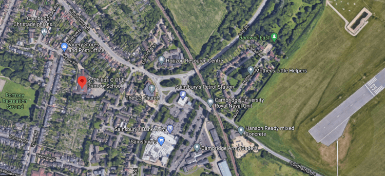
Above – a reminder from GMaps here.
If future plans are going to be as radical as the climate emergency tells us they need to be, then maybe we need to imagine the transport infrastructure that needs to be in place by 2040 – one that does not involve transportation powered by fossil fuels.
More climate-related restrictions and parameters
Another report from the first round of analytical reports commissioned for the next local plan puts car travel in sharp focus – and that’s assuming zero carbon policies in place elsewhere. (How realistic is that scenario?)
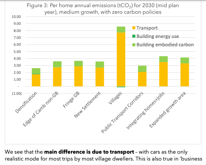
Above – from the Greater Cambridge Local Plan – Strategic spatial options appraisal:
implications for carbon emissions, Nov 2020.
Those transport emissions have to come down. The ‘do nothing’ option means very high emissions from village-based commuters outside of Cambridge. Even if new infrastructure is planned, the time it’ll take to build it means even by 2030 we’ll still be too dependent on fossil-fuelled transport. Even the diesel emissions from the guided busway and diesel trains make a mark. Interestingly the model that this is based on is due to be replaced – that one dating from 2006. (See the Combined Authority Paper here, and the announcement here).
“This is so complicated it’s hurting my head!”
So if your head isn’t hurting like mine, and you can bear to scrutinise the very detailed documents recently published that examine future scenarios, please see the links in my previous blogpost here. (And feel free to share them too). Because they raise a whole host of issues that really need to be raised up the political agenda with the elections looming.
Otherwise the risk is that politicians and candidates end up making manifesto promises that don’t take into account some of the very hard truths – in particular on the climate emergency, that have now arrived.
