Just as one planning round closes, another one starts – and we go through it all over again!
Scroll down to the end here to look at the maps.
It’s 2020 at the time of writing this, and it will be at least 2031 before any of the sites identified and ultimately selected will be built upon. Building may well extend beyond 2040. At which point I will probably have been turned into plant food or the equivalent as I’ve not considered the thought of living into retirement. I have no desire to live into old age – especially if both my physical and mental health are failing even more than in my 30s.
The large swathes of land identified – how will planners ensure that suitable arts and leisure facilities are built not just to serve the neighbourhood but the city as well?
I had my first football training session today in a quarter of a century. And that was P.E. at school. Today’s session was with Cambridge United’s Mens Mental Health Sessions programme at Coldham’s Common Astro facility – a 2G astroturf pitch but with padding underneath rather than the concrete floors of the old Luton Town plastic pitch. .
You won’t find one of these in a pocket park. But even the 3G all weather surfaces with their rubber crumb piles are not without their critics. The need for indoor sports facilities, and outdoor playing field space is something both Cambridge City Council and South Cambridgeshire District Council have been aware of for a long time. See their most recent strategies:
- Playing Pitch Strategy – Cambridge & South Cambridgeshire 2016-31 (over 500 pages!)
- Indoor Sports Strategy – Cambridge & South Cambridgeshire 2016-31 (over 400 pages!)
It doesn’t need stating that the financial investors will be looking to maximise the return on their investment, so they have a financial incentive to set aside as little land as possible for open parkland and playing fields. At the same time, the CV19 pandemic has taught us the hard way how vital our open green spaces are – as well as access to the countryside. As an aside, campaigning journalist George Monbiot has highlighted the loss of rights to open spaces in a recent Guardian article.
How will all of these new homes be supplied with water given demand already exceeds it?
Undertones lead singer Feargal Sharkey has been campaigning on the poor state of local & regional chalk streams, and accordingly it has risen up the political agenda – it came up as an issue that was debated earlier today in the House of Lords where the minister Zac Goldsmith responded for the Government. Even more interestingly, The Good Law Project is putting a legal team together to challenge The Environment Agency in the High Court, accusing the latter of failing to carry out its legal duties to protect England’s rivers from over-extraction and the routine discharge of untreated sewage by privatised water companies.
Have a look at the Good Law Project here. I also explored the water shortage issue in Cambridge here.
Should the housing on the airport site be enough to prevent house building on other sites?
That’s the take of Jim Chisholm of the Cambridge Cycling Campaign (tweeting in a personal capacity!)
If the surname sounds familiar it’s because he was the one who proposed and campaigned to get a new north-south cycleway built through Cambridge next to the railway line. Decades later and it finally got approval – hence “The Chisholm Trail” being named after him. By no means an easy feat, we are now at the bridge installation stage, with expected completion & opening in 2021.
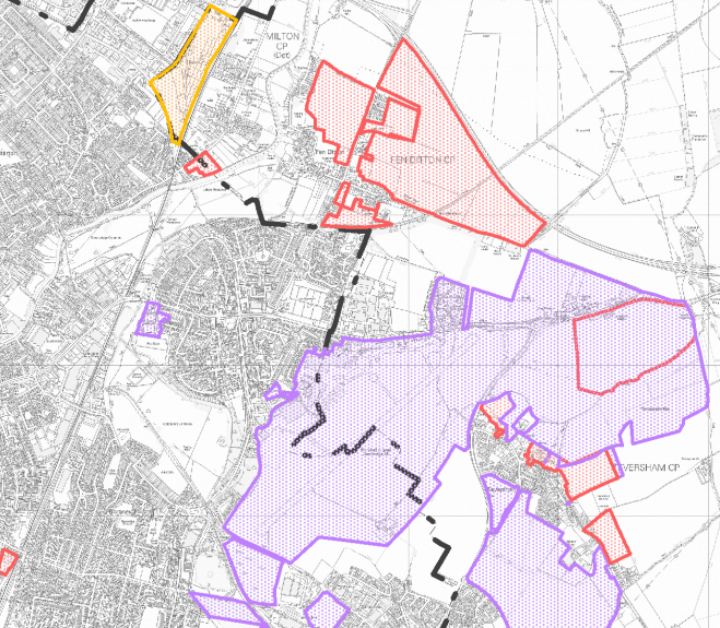
It’s worth noting that the big area of land highlighted in purple that covers the airport also includes some fields on the eastern side of Airport Way. If that got built on along with the other large purple plot on the bottom-right, that would effectively join up the villages of Cherry Hinton and Fen Ditton – or rather the council wards of Cherry Hinton and Abbey, along with the village of Teversham in South Cambridgeshire. This then makes the case for either expanding the city’s boundaries (or overhauling local government in the county) even stronger, as more of South Cambridgeshire bordering the City of Cambridge becomes suburban Cambridge rather than village Cambridgeshire.
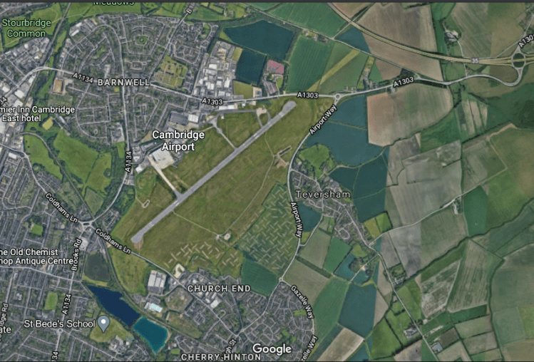
Above – the diagram as viewed on GMaps.
Speculative bids to take land out of the Cambridge Green Belt
Cllr Markus Gehring (Lib Dems – Newnham) noted this in South-West Cambridge.
There are also further significant bids on land south east of the M11 Junction near Harston.
Essentially the bid there is to take Shelford Road and fill in the gap between the road – a classic example of interwar ribbon development, and the M11. There’s also another go on the hills of Lime Kiln Hill in South East Cambridge – which personally I think is a stupid idea as it is one of the very few green hills that Cambridge actually has. If anything that area could be turned into an additional park for Cambridge if they could properly secure the recently rebuilt Netherhall School premises that also sit on the site. At present – and quite understandably, the site is out-of-bounds to the public because it’s a school site, and child protection must be paramount.
Building on University college playing fields
Quietly tucked away behind a row of expensive houses are some of the Clare College playing fields.


The aerial shot from GMaps shows the old Cambridge University Press buildings. It almost feels inevitable that this piece of land will get built upon in the next 20 years. It’s too close to the railway station not to be used as commuter flats for workers in London – assuming a cure and/or vaccine is developed for CV19. This means that the development will more than likely contain identikit medium-high density buildings.
On the other side west of Trumpington Road is what looks like another speculative bid given its very close proximity to Granchester Meadows. The prospect of development bids sandwiching the homes along Bentley Road, Barrow Road and Porson Road will inevitably generate opposition from local residents there as well as villagers in Granchester, determined to preserve the tranquility of the village.
For years I’ve wondered why the row of detached houses that starts at Brooklands Avenue did not continue ribbon-style all the way through to Trumpington. It may have been that Davidge’s Cambridge Regional Plan from the 1930s was able to put a stop to it. Given the presence of two high profile private prep schools on the other side of the road, I can imagine demand from affluent families for detached properties built on that land would be very strong indeed. Alternatively, in 20 years time the debate on public services might have turned on its head and a future government might abolish private schools, as was very seriously discussed in national politics throughout the 20th Century until the 1980s.
