
Could happen – if the wealthy landowners agree.
I’m assuming they are wealthy. But we don’t know because successive governments have chosen to withhold making Land Registry data public and free to access. But if we are looking at local responses to the Cambridgeshire & Peterborough Independent Climate Commission’s Report, then this is the sort of proposal and challenge we need to consider.
If we look at the history and why we have so little forest cover, part of it is to do with the Second World War.
“Farming underwent an enormous change because whereas for the previous two decades there had been an agricultural depression farm produce was in demand and the land under the plough in the Isle of Ely rose from 12 million acres to 19 million acres and there were a lot of stories about new land being ploughed and photographs of bog oaks being dug out and laid along roadsides”
Fenland Family History Soc citing historian Mike Petty MBE
That is a significant area of land – and only covers what is now Fenland District Council plus part of East Cambs District Council. Huge areas of Cambridge County – Cambridge, South Cambs, and the southern bit of East Cambs, also went under the plough. So part of the plan on re-wilding might involve going over old maps and identifying which are the areas that were once wilderness.
But that’s not the only issue we have with land and maps.
“Many of the problems we identify in this report are caused or exacerbated by the UK’s exceptional lack of transparency on land. Communities do not know how the land around them is owned and controlled. Local residents find the planning process confusing and opaque.”
Land for the many – a report to the Labour Party 2019.
It’s only when protests seem to arise that we find out a little of who owns what – such as the Skaters Meadow at the northern edge of Grantchester Meadows.
***Oh Rupert Brooke! He’s my hero! Don’t you know Lady T unveiled a statue of him?***
I don’t know if anyone told the organisers that Rupert Brooke despised the Conservative politicians of his day – campaigning against them in one of the general elections of 1910. You can read what he said in Cambridge about Democracy and The Arts to the Cambridge Fabian Society. Below is a letter Rupert Brooke sent to Hugh Dalton from the National Liberal Club in Whitehall.
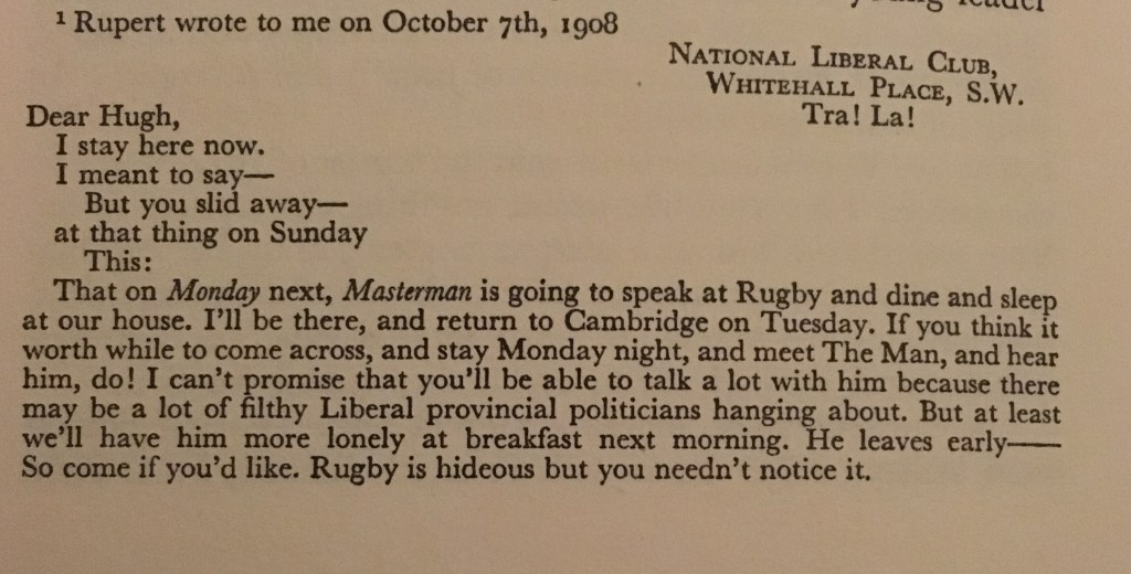
Less than 15 years later, Dalton would be only the second man to stand for Parliament as a Labour Party Candidate in Cambridge Borough – and would become Chancellor of the Exchequer in 1945.
Grantchester Meadows
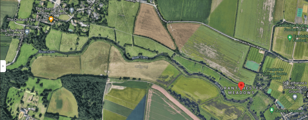
You can explore them on G-Maps here. Northwards is that way –>>
In 1934, Mr Davidge suggested having a major ring road passing through the meadows as a means to divert traffic away from Cambridge City Centre. At the time, all of the road traffic went through Cambridge, and even as early as the 1920s it was becoming a bit of a nightmare.
At the same time, the Cambridge Preservation Society had been formed – today Cambridge PPF. Their remit was to stop the spoiling of Cambridge and prevent urban sprawl. So the idea of building over Grantchester Meadows diminished – not least because people who actually knew Rupert Brooke personally – such as Sir Geoffrey Keynes (Florence’s younger son) were supporters of the new campaign. Also the transport engineers ran the risk of a riot from Brooke’s poetry fan club.
In the end it wasn’t until the late 1970s that the long-proposed Cambridge Western Bypass was actually commenced. By that time, what might have been a single carriage road ended up being a motorway – the M11. And it was kept sufficiently far away to placate most people – though I still think the noise from the road is still audible from the meadows and ruins the atmosphere. The dull hum of the internal combustion & diesel engines along with the roar of rubber tyres as they speed along the black tar rivers.
Re-wilding the River Cam’s upper courses
We saw the impact of flash flooding in London due to intense downpours not so long ago – and how it took out a number of tube stations. It’s only a matter of time before everywhere else faces similar and we have to do something about our urban infrastructure. But before that happens, we can take steps collectively to alleviate and mitigate some of the risk by re-wilding.
Given the demand for publicly accessible open spaces, I’d have the eastern side of the meadows re-wilded, with a wide footpath and cyclepath alongside. Rather than have the adjacent fields used for crops, I’d turn them into a mix of community orchards and woodland, mindful of just how small an area of Cambridgeshire is actually covered by trees.
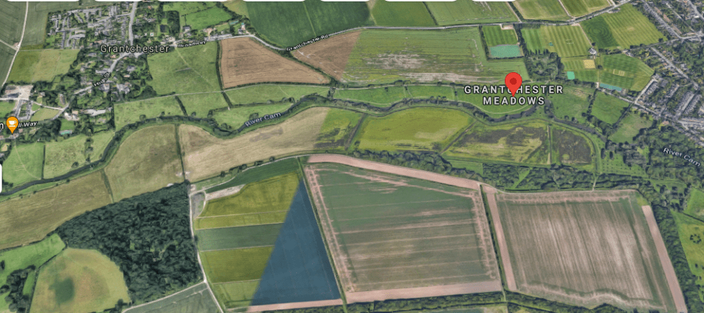
Above – from G-Maps here. The soil erosion in the two large beige/green fields is clearly visible. Move further west and you hit the M11 that causes all of the noise.

Above – from GMaps here. Grantchester is in the top right. The River Cam is in the wooded bit running along the bottom west-north-westwards heading upstream, heading under the M11 before swinging round and heading to the foot of the picture bottom left. It’s at that point where a large flood pond or lake that could be used for leisure purposes could be created. Or on the other side if needs be. Again, there is the opportunity to re-wild the fields on the on the northern/eastern side of the M11 to reduce noise.
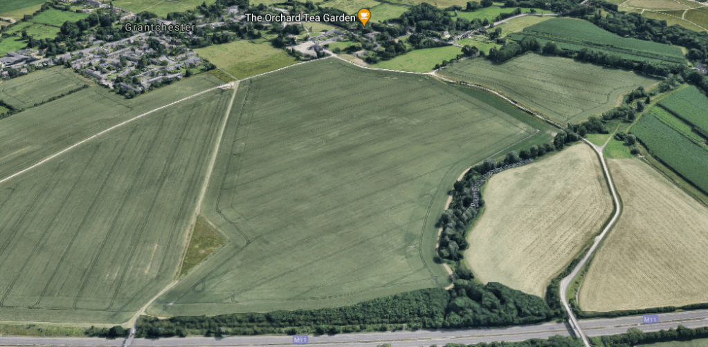
Above – from G-Maps here. The M11 runs along the bottom, and the noise from the M11 can easily be heard in the Orchard Tea Garden because there is nothing to block the sound from the road. There are a host of solutions that can be used in combination with each other, not just re-foresting or re-wilding. For example the use of recycled materials such as plastic and rubber tyres has been used. A combination of re-wilded or re-forested meadows would significantly reduce surface run-off, increase percolation of rainwater deep into the ground, and reduce the intensity of flash flooding originating from the upper course of the Cam, protecting the properties close to the river as it goes through town. Further barriers of trees along with man-made barriers as in the link above would have the added benefit of reducing the noise of the motor traffic in the surrounding villages. But it’s up to the landowners, local and central government to come to an agreement to make this happen.
What is the flood risk?
According to a joint assessment from Cambridge & South Cambs councils:

So you can see where the main risks are for the City of Cambridge. Slow the flow of water draining off of the land during intense and/or extended rain storms, and have some large flood ponds/lakes that can take and hold excess overflows while creating new amenities for local residents. The same is true if Cambridge gets its long awaited Sports Lakes between Cambridge and Waterbeach. Again, it creates new amenities – and also takes on the excess demand for river rowing space, while at the same time mitigating the flash flooding risk further downstream at places like Ely and Wisbech.
Building safe and accessible access by cycle and public transport.
One of the things that created the furore over Skaters Meadow was both concerns about health and safety, and damage to wildlife. Hence the need to open up more of the riverbanks to the public so people are not concentrated in one spot, and creating alternative transport access arrangements that don’t involve cars.
Missed opportunity

Above – South Trumpington on G-Maps here. You can see the curved path of the guided busway and adjacent cycleway at Trumpington Park Primary School. It’s on the old Oxford-Cambridge Varsity Railway Line. You can also see how the dumping of the Trumpington Park and Ride car park has effectively blocked what might have been a useful and handy cycleway out to the River Cam and up towards Byron’s Pool. My late aunt took me there on. a picnic in the late 1980s. I couldn’t see what the big deal was at the time, but I managed to catch a three-spined stickleback and put it in a jar. But it died of shock by the time I got home. Poor thing.
This comes back to the point that transport infrastructure cannot simply be a function of commuting routes, whether to work or study. In the era of the electric bikes and cargo bikes, urban and transport planning should involve designing for multiple tasks in a single outing. That also needs a culture change for us men too. I think we’re getting there – the Cambridge Cycling Campaign (of which I’m a member) recently announced its membership numbers had exceeded 1,600 people for the very first time. (That’s *a lot* of passionate, often highly educated (i.e. to degree level and beyond) civic-minded people (who read the local council meeting documents and can decipher them) who not only campaign but get out and vote – which is why politicians from all parties pay attention to their work). For pedestrians there is now the Cambridge Branch of the national campaign, Living Streets. And if you want to walk further, the Cambridgeshire & Peterborough Ramblers are here – their direct action pre-dating Extinction Rebellion by around 90 years with the Kinder Scout Trespass of 1932. Remember that thing about the Land Registry data?
So yes, let’s re-wild more of the Grantchester Meadows, and also at the same time make more of the meadows accessible to more people by cycle and public transport, and not by fossil-fuel-powered motor cars.
Food for thought?
If you are interested in the longer term future of Cambridge, and on what happens at the local democracy meetings where decisions are made, feel free to:
- Follow me on Twitter
- Like my Facebook page
- Consider a small subscription to help fund my continued research and reporting on local democracy in and around Cambridge.