So I don’t forget – but also it covers sites and issues that would have been missed out in the call for sites.
Which involves comparing the First Proposals map here… (and screengrabbed below…)

…with the site submissions map from developers and landowners here – and also screengrabbed below:
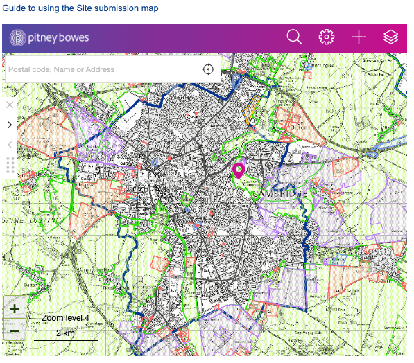
One thing to note is that the site submissions map does not contain sites that were incorporated into the 2018 local plan and are already being worked on. Such as North East Cambridge (The Sewage Works).
Opportunity Areas – to be aware
These are the bits to be interested in – shaded in light brown. These areas will be of interest not just to nearby residents, but to local historians and environmentalists as well.

Let’s go through a few:
Castle Hill – the Shire Hall site
See p68 of the Committee draft local plan 2030-41 here.
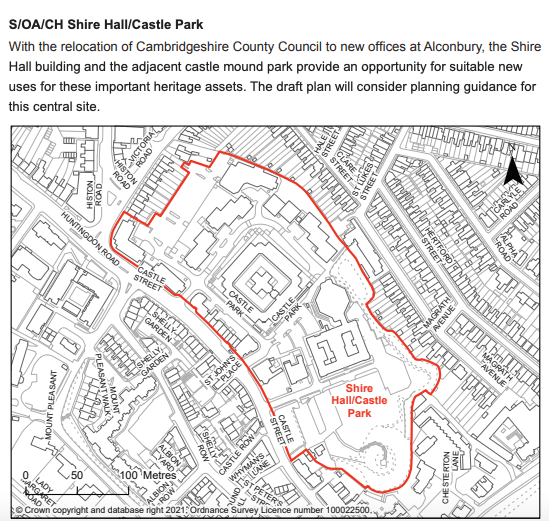
Above. Much as I would like it to read:
“Site currently occupied by Puffles for the purposes of building an expanded Museum of Cambridge. As Puffles is a dragon, ****leave well alone**** * I can’t see that happening.
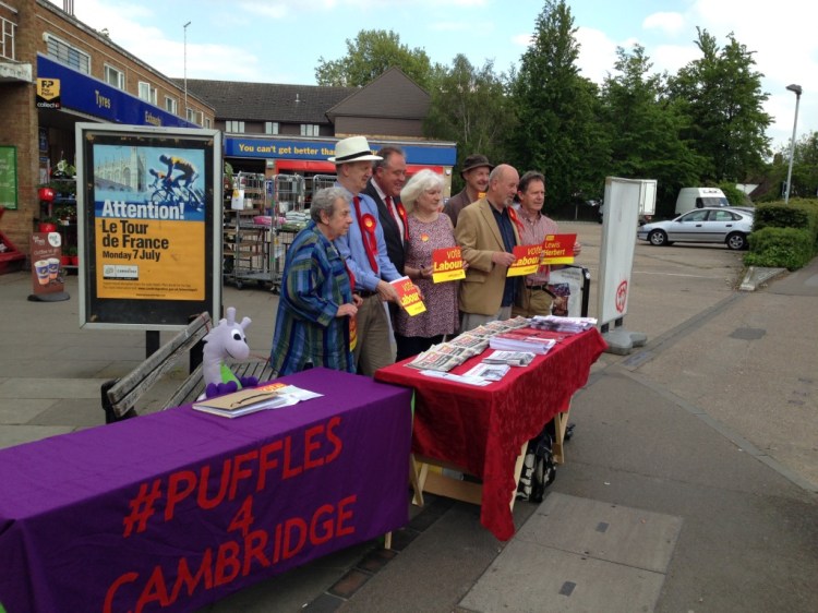
Above – Challenging the politicians – Puffles the Dragon Fairy in 2014 in the process of thumping UKIP at the ballot box in Coleridge Ward in the city council elections that year
So…keep an eye on that one to see what others may propose for it.
Henry Giles House, and Mitcham’s Corner
Almost next door to the site is the Job Centre – Henry Giles House, formerly Sir Horace Darwin’s Factory of the Cambridge Scientific Instrument Company. That’s also next to the Mitcham’s Corner Opportunity Area – an area that generations of planners have struggled with. The Friends of Mitcham’s Corner have the local history. Below: Lost Cambridge hero Sir Horace Darwin in the robes of Mayor of Cambridge (1896-97), before his knighthood a few decades later.

You may be familiar with is wife Lady Ida Darwin. She appears in the Local Plan as a hospital site – we named a hospital after this mental healthcare pioneer and hero in her own right – as historian Ann Kennedy Smith describes.
Cambridge United Football Club
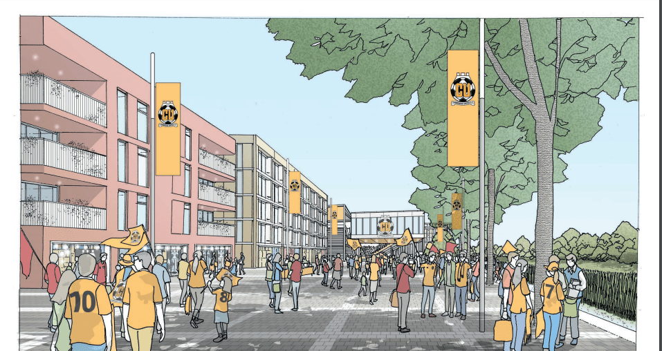
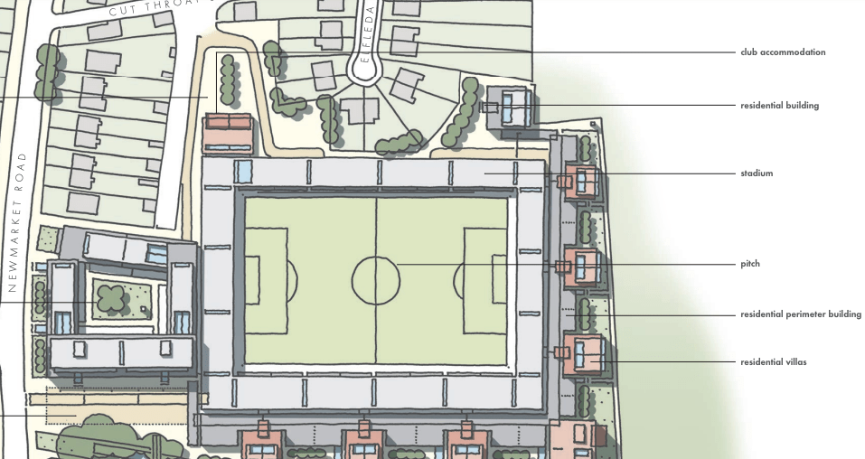

I remain unconvinced of the principle of building hotels and residences into football stadia as a concept. I can understand the financial incentive, but I’d rather a new ground was built say on the Airport site or elsewhere, and the exiting site sold for housing. See https://oc2.greatercambridgeplanning.org/form/40123 and click on the Supporting Evidence tab for more.
Newmarket Road Retail Park

Formerly the site of one of Cambridge’s brickworks which dug very big holes in the ground for the raw materials, they made ideal sites for previous generations to dump all manner of things into – without telling anyone what they were dumping.

Above – from the National Library of Scotland’s maps online – Cambridge 1956. You can see the circles denoting the Cambridge Gas Works. On the other side, the Brick & Tile Works and the pits which shortly became exhausted of the clay needed to make bricks. Thus the site became ideal for those wanting to dispose of waste without giving much thought to the consequences.
So ***all sorts of nasties*** are buried under there. Once that municipal dump was closed in the 1960s, it moved to the quarry at the other end of Coldham’s Lane by the airport & Sainsbury’s. When that filled up, it moved to Milton. The only thing the site was suitable for was car parks and warehouse retail, sealing up what was underneath to be forgotten for ever. But then land prices in Cambridge have sky-rocketed, making the site of interest to developers despite the prohibitive costs of land remediation. Unsealing the lid on the old municipal dump?
***Do not open that trap door!***
Actually, the site is probably worth more than enough money to justify recycling the land. One of the options thematically could be to take inspiration from The Kite Renewal Proposals of 1976 – which were rejected for comprehensive redevelopment and The Grafton Centre.
The Beehive Centre – the graveyard of the Cambridge & District Co-operative Society
Like the Cambridge Conservative Association, the Cambridge and District Co-operative Society was one of the biggest civic society organisations in Cambridge’s 20th Century History. And they both imploded in the 1980s, almost ceasing to exist by the Millennium.
There’s a Ph.D awaiting someone who wants to research either. Personally I don’t think the history of Cambridge the town can be properly understood without in depth studies of both institutions – and it needs to happen soon while the individuals involved are still alive.
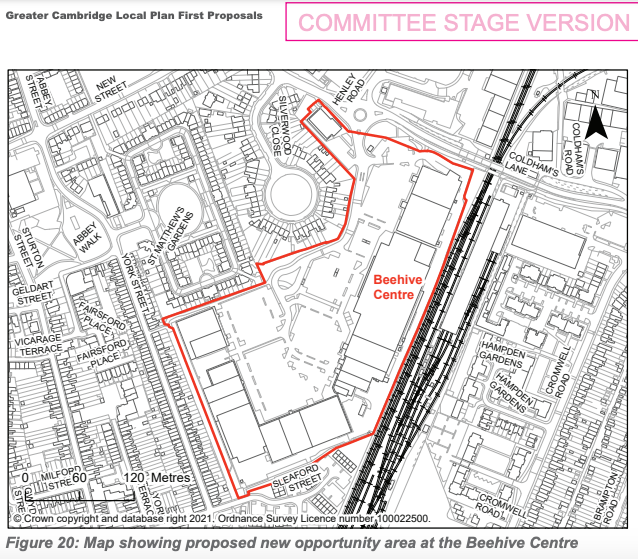
The summary of the demise of the Co-op I’ve blogged about here. They put all their money into redeveloping this site, and lost the lot – not helped at all by economic mismanagement of the economy by successive governments who raised interest rates to eye-wateringly high levels. The site also contains the bones of a former manufacturing and media giant – PYE. Almost every other family in the mid-20thC that had a radio or music player had one made by PYE. The Museum of Technology at the old Pumping Station are custodians of their story
Although it barely shows on the maps, the PYE Cambridge works on York Street was a huge manufacturing operation. You can read more on https://www.pye-story.org/companies/pye-sites/cambridge-sites where the photograph below is from.
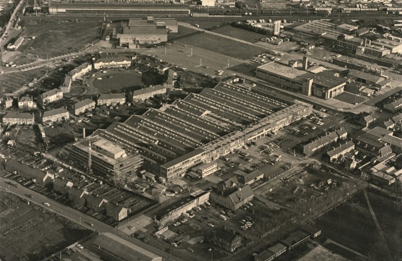
Above – with Coldham’s Lane running diagonally at the bottom, and with the railway line running horizontally along the top, with what looks like the early Beehive Centre Co-op store, you can sort of see why the Cambridge and District Co-op would locate a new supermarket next to a very large industrial employer.
Newmarket Road, Mill Road, and Hills Road Opportunity Areas
Little to add for now other than these are main routes into Cambridge – although attempts to restrict motor traffic on Mill Road have remained controversial. The https://millroad4people.org/ is one of the groups calling for motor traffic to be restricted. They are opposed by the Mill Road Traders Assoc. That will run.
Newmarket Road, and Hills Road remain missed opportunities as far as iconic, outstanding, and awe-inspiring architecture is concerned. The western end of Newmarket Road is becoming a thoroughfare with budget mass market hotels becoming prominent next to the warehouse retail brands – despite the continued and persistent campaigns from local residents who quite frankly have deserved much better for their hard work. The problem as ever is in national government.
For those of you interested in Newmarket Road, have a look at Cambridge City Council’s appraisal of the road from 2011 here.
Hills Road has a slightly different economic sector demolishing and rebuilding on sites throughout the latter part of the 20th Century and over the past couple of decades. Again, unremarkable architectural is easy to spot – to the extent that even Cambridge City Council’s appraisal of Hills Road labelled a number of buildings as detracting from the street scene.
Below: The appraisal and key from Cambridge Suburbs & Approaches 2012. By Cambridge City Council.

Above – the top-left building replaced the old Wesleyan Chapel. The white building below was extended along the street, and the chapel lost after the Methodists gave up the lease on the site.
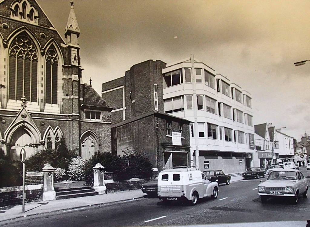
Above – photo via Mike Petty MBE.
Below: Cambridge City Council’s appraisal for Hills Road by the railway bridge: Locals will be familiar with the repeated attempts over the decades to make it look nice.
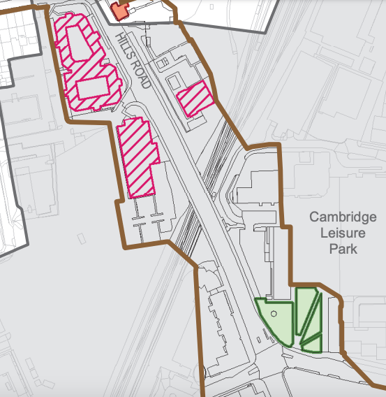
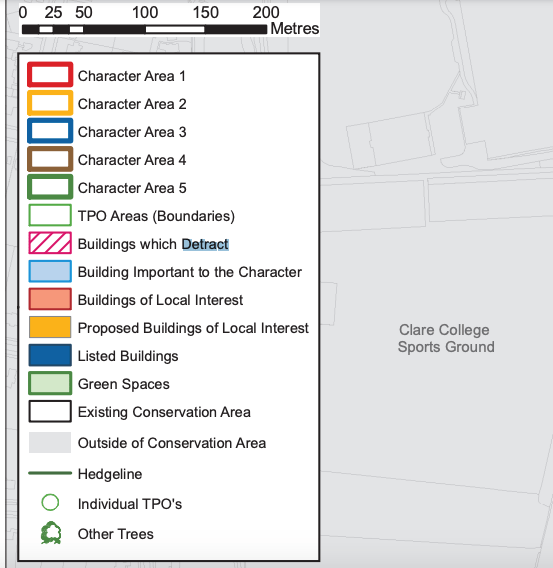
Above – note the diagonal red shading indicating buildings that detract.
For those of you interested in the Mill Road appraisal, have a look here – which was completed in June 2011.
And the rest?
No major surprises.
The University of Cambridge continues expanding in the North West until it hits the A14 & M11. The Cambridge Biomedical Campus 2050 vision remains as controversial as ever because ***where is all of the water going to come from?***
Reminding ourselves of the consultants’ report by Stantec on water resources:

Above – by Stantec advising the councils:
“There is no environmental capacity for additional development in the new Local Plan to be supplied with water by increased abstraction from the Chalk Aquifer.“
If the developers and their financiers don’t like this, they better get involved in Water Resources East and start going after the Water industry.
The airport site remains an interesting and intriguing site – not least because of the options available but also because of the constraints such as the requirement for a net biodiversity gain, which means developers and urban designers will have to come up with something much more imaginative than standard minimum cost bland design housing estates. Replacing a site with all of the aviation emissions with something that is very likely to include a new urban country park can only be a good thing. But we must make that case as residents.
Food for thought?
If you are interested in the longer term future of Cambridge, and on what happens at the local democracy meetings where decisions are made, feel free to:
- Follow me on Twitter
- Like my Facebook page
- Consider a small subscription or donation to help fund my continued research and reporting on local democracy in and around Cambridge.