How do the 24 visions published in 2015 look today, having been through Brexit and still in the midst of a global pandemic?
Being stuck indoors for much of the time these days sort of has its advantages when exploring through published documents, but I wouldn’t wish brainfog or chronic fatigue on anyone. I’m sort of making the most of the past 48 hours of alertness before another trough kicks in – mindful of the Universal Credit hoops I’ve been jumping through of late. Which reminds me, I have to let them know of any contributions with all of this so if you’ve found the recent posts useful, please consider contributing to Dusk the Town Owl’s coffee fund! (You can spot Dusk at the top of the Guildhall next to the clock on the right hand side).
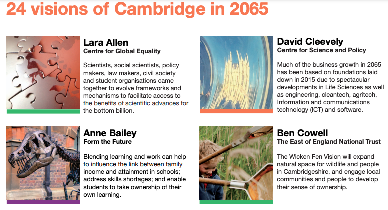
Cambridge 2065 – what 24 hand-picked people (not including me) foresaw.
You can read the 2015 report here. It is an unfinished piece of work, as Cllr Sam Davies (Ind – Queen Edith’s, Cambridge City Council) reminds us.
I summarised the 2015 visions into one-liners back in this 2017 blogpost. Having also been through the last local planning process, local communities in and around Cambridge are now much more wiser to the process than they were before. This is largely thanks to the Federation of Cambridge Residents Associations who organised people and communities to follow the hearings closely. (See their Youtube Playlist here). You can also browse through the playlists of the local plan hearings they commissioned me to film in the run up to 2018. (See the playlist lists here). For those of you less familiar with the process, have a listen to the presentation to the Queen Edith’s Community Forum (in South Cambridge) just before the first lockdown in 2020 below:
Above – Paul Frainer of the Cambridge & South Cambridgeshire Shared Planning Service at St John’s Church Hall on Hills Road, Cambridge.
The consultation goes live on 01 November, but you can look at the background materials at https://consultations.greatercambridgeplanning.org/
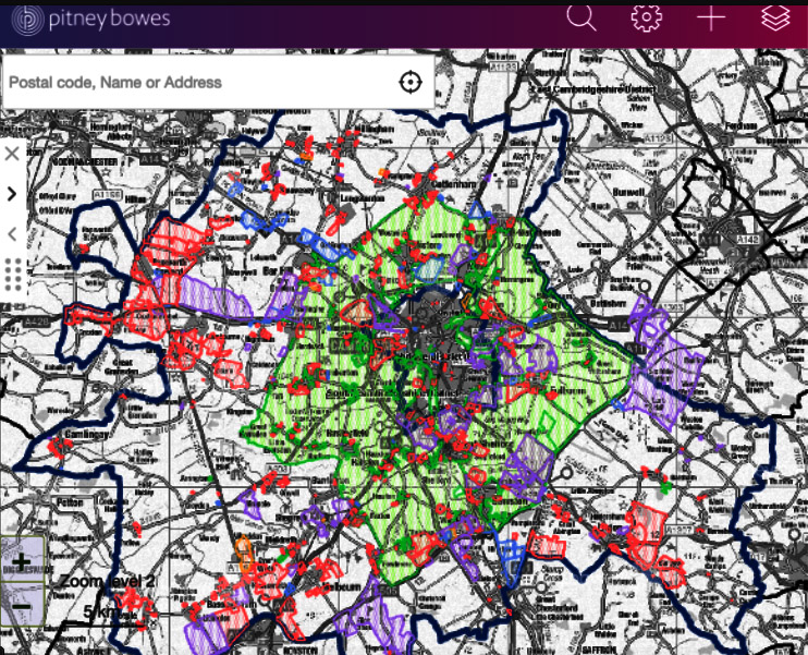
What the developers want – and where they might build if all of their bids are approved* (*they won’t be, but it’s useful to know)
First of all there are a whole host of assumptions with this approach, which is why the map you are about to see does not automatically mean the blue/purple/red shaded areas will all have multi-storey tower blocks of luxury apartments owned by shady groups based in some Crown-owned tax haven having been sold on the international property markets. If the Chancellor of the Exchequer or any of his predecessors wanted to clamp down on property ownership by individuals and firms domiciled abroad, they could follow New Zealand’s example. They have chosen not to. That is a party political decision. That is something the electorate may wish to consider at future elections.
The big assumption again with this map is that all bids get approved anytime between the emerging local plan 2030-41, or in future ones over the next few decades. Let’s go to the PB map on the Greater Cambridge Planning Portal – click https://www.greatercambridgeplanning.org/emerging-plans-and-guidance/greater-cambridge-local-plan/document-library/site-submissions/
If the above looks confusing, I’ve created a ‘how to’ guide halfway down this blogpost.
Now, the above is noticeably different in a number of places to the draft plan and map that the Greater Cambridge Planning released not so long ago. The map of site being considered in their first iteration is below:
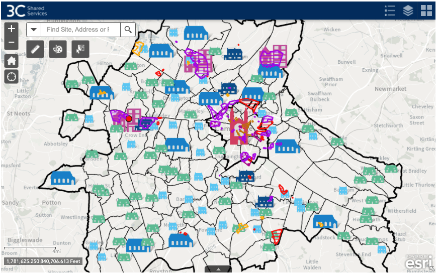
You can explore the above map here.
Now the above map is full of symbols that at first glance *do not show what is going to be built and where*. What it shows is the ranking system of settlements for Cambridge and South Cambridgeshire district council areas.
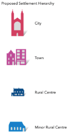
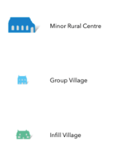
Above – that’s all the icons mean.
What the local plan proposals then contain are proposed conditions for any planning application that is submitted in the planning period (i.e. 2030-2041) dependent on the type of settlement the village/town is.
Let’s look at the first draft that councillors discussed earlier this week – see the papers here. Click on 4a: Appendix A: Greater Cambridge Local Plan: First Proposals (Preferred Options) (42MB). Have a look at p47.
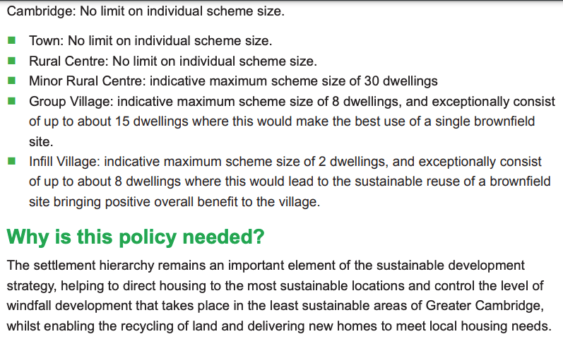
It is very straight forward – minor rural centres cannot have schemes with more than 30 dwellings. Smaller villages the limit is even smaller. It also does not mean that developers can start building monster tower blocks in rural centres either. So the people for example of Comberton are safe. For now.
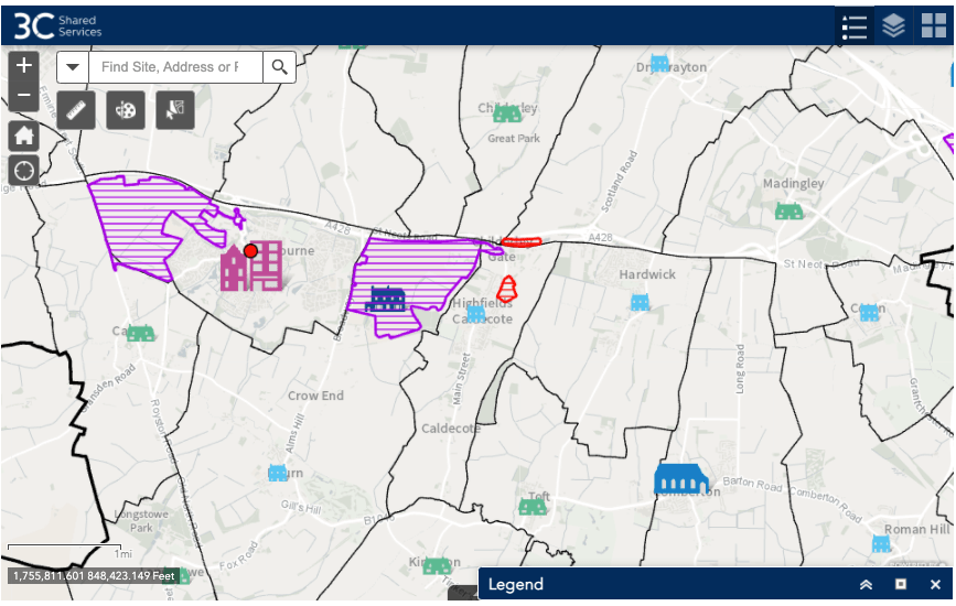
Above – zooming into Cambourne on the first draft map. You can see Bourn has been identified as a rural centre, and Cambourne has been identified as a town in its own right. It has a constituted town council. Comberton has been identified as a minor rural centre. If these proposals in the first draft are adopted, then any development over 30 dwellings planned for Comberton ***will be recommended for refusal*** as being contrary to the local plan. Any approval from councillors will have to be signed off by a minister as being a development contrary to the local plan.
Predicting the distant future? Good luck with that!
I will be over 60 by the time we hit that point, and I don’t know about you but I’m not planning to live deep into old age – mainly because things are a struggle already with chronic fatigue. Old age isn’t going to make things any easier. It also means for my generation of Xennials engaging in the local planning process that much of what we do is not for us, but for future generations. Which might seem like a strange concept if you’re still in your 30s and are a child of the Thatcher generation.
Who knows what the future will bring? Comparing 2021 with 2041 is like comparing 1991 with 2011. For me, ***a lot of massive changes happened*** in those 20 years where I went from being 11 to 31. And that’s before we’ve even looked at technological, societal, and political changes. In 1991 Cambridge had a Conservative MP and Cambridge Conservative Councillors were regularly in local newspapers. In 2011 it was more like “What is a Cambridge Conservative councillor and what do they stand for?” Because there weren’t any. There still are none today. Which is quite a change from what it used to be like before WW2. (Don’t think the situation can never be reversed either).
Greater Cambridge Beyond 2041
One thing we know from previous local planning processes is that institutional financiers and developers will keep coming back so long as there is a strong financial incentive to promote their schemes. This is why the submitted evidence with the first round of site submissions is ever so important – and interesting…and useful. Let’s go back to the pre-draft submissions map here. Last night I went off on an online expedition to find lots of these otherwise buried proposals. It was a little bit like this.
One site after another revealed proposals for development – put together by expensive consultants with significant in-depth studies along with them.


As I went through them I was like: ***Oooh! You look like fun!***
And that’s on top of the other ones I had spotted in previous blogposts.


Above. To find the documents, simply browse the PB Map here, click on any purple, blue, or red-shaded area to show the scheme submitted.

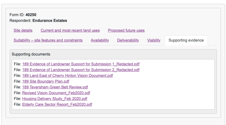
Click on “Click to open” on the JDI link above…
…and you get a pop-up that looks like this. Click on the supporting evidence tab at the bottom right of your screen…
“…and B.I.N.G. – B-I-N-G-N-G-O!“
…if you are that way inclined. Alternatively, you might take a more considered view and note the independent (and very expensively-commissioned) studies submitted in support of the submissions – ones which I take from a social scientific perspective and should also be analysed as such.
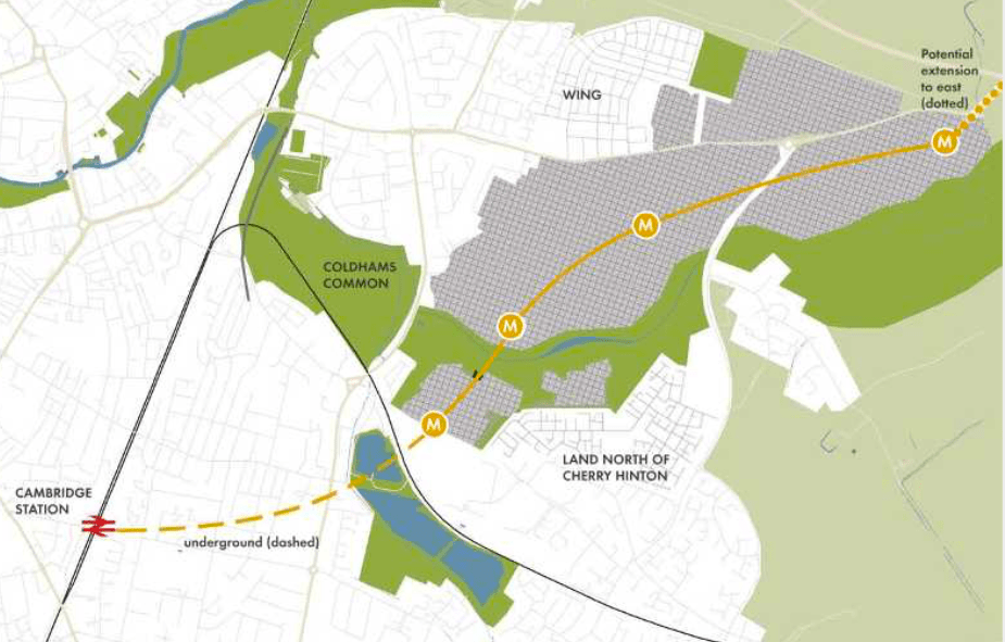
Some of the better-planned ones (yes – really!) try to explore challenges that go beyond the immediate development. Take the airport site, one of the major sites under consideration. You can read the extensive literature at https://oc2.greatercambridgeplanning.org/form/40306 clicking on the ‘Supporting Evidence’ tab. In the masterplan they know already of the Newmarket Road congestion. So pre-2021 mayoral elections they started exploring where any metro stops might go.
We can also see who owns what land.

Thus Cambridgeshire County Council becomes an interested party – as do their elected councillors.
The strategic shortcoming if we go with the existing piecemeal approach of releasing more land with each successive local plan
The history of King’s College Chapel, Cambridge gives a hint.
The college was founded by Henry VI in 1441, and work began on the Chapel five years later. By the time it was completed in 1515, a new dynasty was on the throne, and the young King Henry VIII and his influential Spanish Queen Katherine of Aragon were on the throne. Let’s not forget Queen Katherine was a very popular Queen consort as Queens go. She rests inside Peterborough Cathedral up the road. So in the time of the construction of King’s College Chapel, huge political changes had taken place. And that’s before Henry VIII’s split from Rome and the English Reformation.
So my two questions – or rather, proposed lines of inquiry for anyone interested are:
- How will the deliberations on the next Greater Cambridge local plan be affected by the politics of both the Climate Emergency and the Covid Pandemic?
- How can Greater Cambridge overcome the major shortcomings of the existing local planning approach that at present has failed to allocate significant areas of land for arts and leisure, and has under-allocated enough large open green spaces for people to enjoy?
Any responses from institutions should also cover the settlements that will see the greatest level of housing growth – the new towns of Waterbeach Town, Cambourne, and Northstowe. Recall in my previous blogpost I also called for each of these new towns to have a leisure attraction that not only serves the town but also surrounding villages and Cambridge as well. Otherwise they risk becoming dormitory towns with nothing happening. I gave some examples of what they could host:
- Waterbeach Town – Cambridge Sport Lakes
- Northstowe – An indoor rollerrink (for the Rollerbillies) and large skatepark. (Build it as close to the guided busway and cycleway as possible)
- Cambourne – A very large adventure playground on a scale not seen within a 40 mile radius.
I also make a similar call with the Cambridge Airport site saying that it could host a new Lifelong Learning College with its own outdoor playing fields accessible to the public, opening out onto an urban country park, and having its own public transport interchange (ideally part of the Cambridge Connect Light Rail Project) that makes the facility accessible to the entire sub-region and beyond.
Finally I come back to the future vision.
Both the 1934 and the 1950 plans hint at something.
Professor A.B. Ramsey in his introduction to the 1934 report stated:
“The dream of a Cambridgeshire for ever beautiful is one which it is worth united and unselfish action to realise”
Prof A.B. Ramsay, Vice Chancellor of Cambridge University 1929-31, Master of Magdalene College, Cambridge 1925-47, in Davidge, W.R. Cambridgeshire Regional Plan (1934).
While Sir William Holford and Prof Myles Wright tried to deal with the traffic problem as much as anything else.
“In the past, road improvements in Cambridge have been considered piecemeal. We determined that this mistake at any rate was one we would avoid.”
Holford & Wright 1950, p5
Replace the word “Road” with “Transport”. Knowing what we know now with the limits of growth on road building for private motor cars, and the lesson Holford & Wright provide us with is to design a network rather than piecemeal improvements. That can be the Greater Cambridge Greenways as much as it could be a light rail project. Personally I agree that the Greenways project should be extended to the north and west of the county as a matter of urgency – creating both jobs and new active travel routes for residents. Assuming Brexit hasn’t broken all of the supply chains. But after last night’s reports from Cllr Davies, I’m not convinced.
HGV driver shortage affecting transport works too.
There’s still a long way to go.
If you are interested in the longer term future of Cambridge, and on what happens at the local democracy meetings where decisions are made, feel free to:
- Follow me on Twitter
- Like my Facebook page
- Consider a small subscription or donation to help fund my continued research and reporting on local democracy in and around Cambridge.