…at the second time of asking following the city council elections that left the council under no overall control. Plus a look at the Connectivity paper for the Combined Authority
Image: Cambridge Matters by Cambridge City Council (the cover from summer 2023. In the current edition, p13 has a breakdown of council spending)
You can see the official announcement here following the recent vote at Full Council earlier this evening (01 June 2026). See:
It was the change in position by the Liberal Democrats that enabled Cllr Thornburrow to become leader. Cllr Tim Bick, leader of the Liberal Democrats group explained why his party changed position here. (The Green Party’s nominee Cllr Sefira Davison’s speech is the one before Cllr Bick’s).
Cllr Rosy Moore (Lab – Coleridge) becomes deputy leader
Which keeps up the tradition of my part of town having one councillor on Cambridge City Council’s executive – something that has been a thing since 2014.
For the contested committee chair and vice-chair posts, the Liberal Democrats and Labour appeared to support most of each others’ nominees by the ‘show of hands’ in the room. We’ll have to wait until the updated meeting papers are published to see who has been selected for which committees.
Minor parties get seats on committees
Cllr Hossain (Cons – King’s Hedges) and Cllr Baigent (Ind/Your Party – Romsey) have both been offered seats on committees – in Cllr Baigent’s case he returns to the Planning Committee, where he previously held one of Labour’s seats for a number of years. Planning Committee places require councillors to undertake the necessary training on the planning system – a requirement by law.
The Mayor ran the meeting like she had been a mayor for years
The new Mayor of Cambridge Cllr Maria Cleminson (Greens – Abbey) is one of the new intake of councillors and was elected to the longstanding ceremonial post (i.e. not party political and not an executive function) and has run both the previous and the recent meeting like she was a veteran of local government meetings. (Credit also to Dan Kalley, the Democratic Services Officer working behind the scenes too).
The timetable of provisional meeting dates now goes ahead as planned
Ones to look out for:
- Joint Development Control – 17 June 2026
- Scrutiny: Services, Climate and Communities – 18 June 2026
- Scrutiny: Performance, Assets, Strategy – 23 June 2026
- Planning Committee – 24 June 2026.
Combined Authority Board meets this week (04 June 2026)
The meeting papers have been published here and within them the reports on the State of the Region have been published here. (Item 7).
Above – the Connectivity paper with the summary of key findings on p4 of the report.
The report highlighted the London-centric nature of the rail network in the county – which was the inevitable result of Dr Beeching’s cuts in the 1960s.
“The core movement of rail demand is to and from London, although Cambridge and Peterborough tend to be the most popular destinations from most smaller stations.”
Above – Connectivity (2026) p5
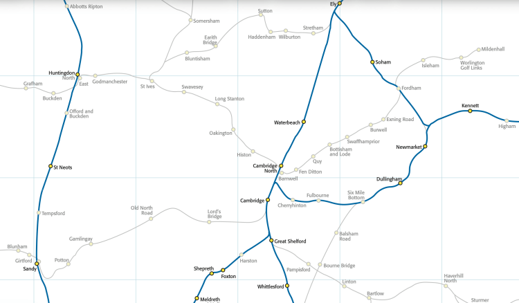
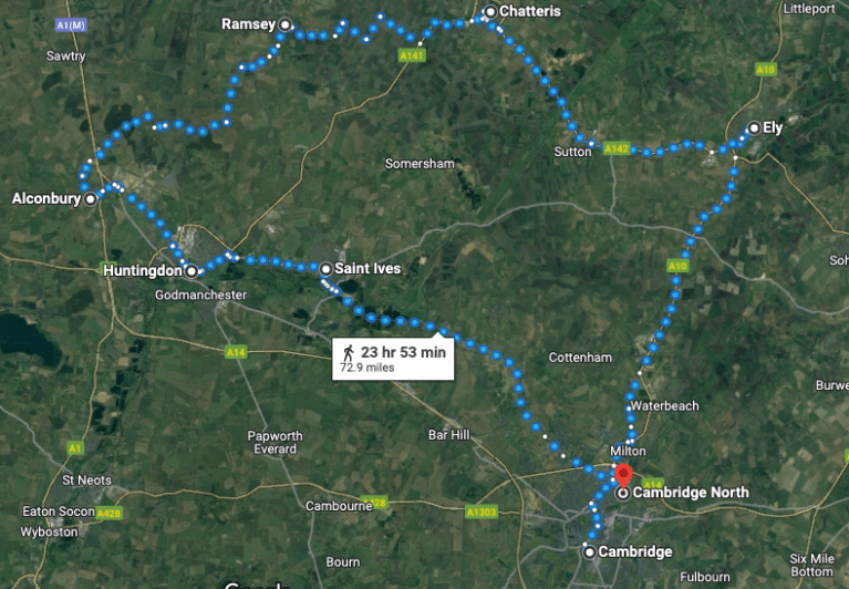
Above – the existing railway network superimposed on the old railway network in/around Cambridge. Source: the New Adlestrop Railway Map
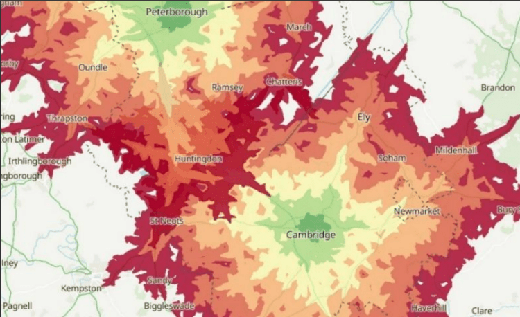
When we compare the above map to the isochrome diagram below which shows 30 minute time journeys from the city centres of Cambridge and Peterborough by bus, you can see how short a distance buses can travel.
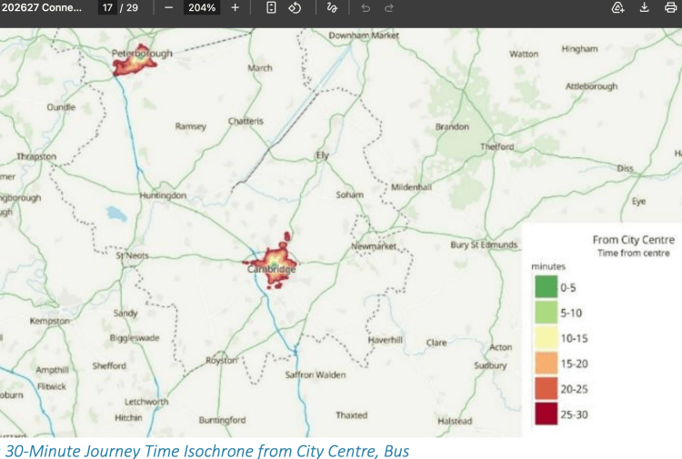
Above – Connectivity (2026) p17
“How do they compare with the old railway services in the 1950s?“
The website Railcar.co.uk has digitised a number of old timetables such as the old Cambridge-St Ives railway here. Note that these services will have been on a poorly-maintained chuggington-style sub-urban branch line using steam locomotives. We’re not talking a smooth, 21st century light rail.
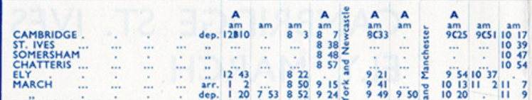
Above – Cambridge – St Ives 1958 at https://www.railcar.co.uk/operations/eastern-region/cambridge-st-ives
Half an hour from Cambridge Station to St Ives where Waitrose is? How does that compare with the 21st Century guided busway from Cambridge Station to St Ives? Let’s have a look at the timetable for the Guided Busway A route.
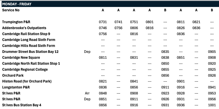
Above – from the Busway.Info website here
Which is why I described ambitions to make Cambridge the most innovative city in Europe as a fantasy going by past and current records.
When we look at the isochrome for car journeys, the 30 minute limits are far greater than they are by bus.
Above – Connectivity – this version from Cambridgeshire Insight at a higher resolution
The poor connectivity between the market towns surrounding Cambridge – Haverhill, Huntingdon, Chatteris, Ramsey, Ely, Huntingdon, St Neots and Biggleswade is striking.
Furthermore, in rush hour the time taken for all of them is inevitably going to be higher than the averages.
Back in 2022 I played with the concept of two light/suburban rail loops for Cambridge, and Peterborough.

Above – from G-Maps: A conceptual Peterborough and North Cambs light rail loop.
The above was part of a series of concepts I played with in this blogpost. As far as Cambridge is concerned, a North-West-of-Cambridge loop would connect up with Chatteris and Ramsey creating a corridor where both towns shared the same rail line that connects the two loops.
Not long after, Anglian Water put out its plans for a reservoir at Chatteris, which I said the two rail loops would support both construction of, and new activities around the reservoir.
It remains to be seen whether ministers and their advisers have the vision to see something like this through – or at least empower local and regional tiers of the state to achieve a similar objective.
If you are interested in the longer term future of Cambridge, and on what happens at the local democracy meetings where decisions are made, feel free to:
- Consider a small donation to help fund my continued research and reporting on local democracy in and around Cambridge
- Follow me on BSky
- Spot me on LinkedIn
- Like my Facebook page

