
I was tipped off by the Cambridge Bus Users for this blogpost – there are a host of assumptions that local residents living near the proposed new large development sites may want to scrutinise
You can read the FB update from the Cambridge Bus Users here (because it’s too long to copy and paste!) There are also a host of public transport papers that need looking at in light of the uncertainty over light rail vs busways, and the looming ban on the sale of new fossil fuelled motor vehicles.
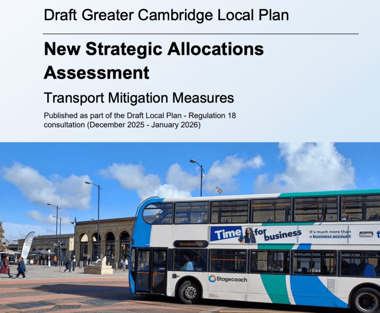
Above – “Draft Greater Cambridge Local Plan: New Strategic Allocations Assessment – Transport Mitigation Measures (2025) (WSP)” which can be found in the document library here.
“What are the strategic sites?”
These ones:
- North East Cambridge (Sewage Works and environs)
- North West Cambridge (Eddington)
- Cambridge East (Airport)
- Babraham Research Campus (beyond South East Cambridge towards Haverhill)
- Cambridge Biomedical Campus (Addenbrooke’s)
- Land adjacent to A11 and A1307 at Grange Farm (Abington where cub/scout camps are)
- Slate Hall Farm, Junction 25, A14 (Bar Hill)
- Cambourne North (Other side of East West Rail new station between Cambridge & St Neots)
I think that summarises it
89 pages of transport mitigation assessment across eight sites
If you come across a paper that looks like this, you’ve got the right one.
Above – By WSP for the GCSP
“What’s WSP?”
An acronym – most things are. But it started off as the William Sale Partnership. Read it on Wikipedia so it must be true.
“What did they conclude?”
From p88
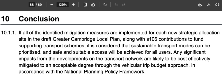
“If all of the identified mitigation measures are implemented for each new strategic allocation site in the draft Greater Cambridge Local Plan, along with s106 contributions to fund supporting transport schemes, it is considered that sustainable transport modes can be prioritised, and safe and suitable access will be achieved for all users. Any significant impacts from the developments on the transport network are likely to be cost effectively mitigated to an acceptable degree through the vehicular trip budget approach, in accordance with the National Planning Policy Framework.”
‘It is considered…by whom exactly?!?’
Send the document back and tell the author and approver to own their recommendations. ‘It is considered that…’ is a nonsense phrase because no one takes ownership of the statement of fact or of opinion.
Far, far better to say: “We consider / our analysis shows…”
The phrase ***vehicular trip budget*** concerns me
“Why?”
Because it appears ***sixty-five times*** in the document.
“What does it mean?”
I’m still trying to figure it out.
“Each proforma sets out the new strategic allocation site location, planned quantum of
development, key movement challenges and opportunities, initial vehicular trip budget and
the identified transport mitigation requirements, drawing on existing evidence bases where available. A vehicular trip budget limits the number of weekday morning and evening vehicle trips allowed to and from each strategic allocation site to manage the impact on the road network.”
“Okay…. “
It goes on.
“Each site-specific transport mitigation requirement is categorised by:
- Location
- Status
- Delivery body
- Funding”
Interestingly the document makes no mention of the Greater Cambridge Development Corporation
This matters because the only funding sources mentioned are:
- Developer-funded works built by the developer
- Section 106 funding where the developer contributes funding towards a larger transport infrastructure project (Eg light rail?!?)
“What do the Vehicular Trip Budgets show?”
For North East Cambridge (Sewage works, Cambridge Science Park, Cambridge North Station)
- Milton Road: AM Peak Hour: 3,900 two-way vehicle flows
- King’s Hedges Road: AM Peak Hour: 780 two-way vehicle flows.
- Target 2045: Between 21-26% trips by car driver mode share
The table on pages 14-19 of the report then go into detail of the different types of mitigation, and then refer to a separate paper titled North East Cambridge Transport Position Statement (2025)” (which if you’re lucky should open here)
The NEC Transport Position Statement (2025) is a ***really complicated piece of work*** and is full of numbers with unfamiliar acronyms attached to them. Some of you may find it easier to prepare your own acronym explainer document because it could get even more frustrating if you go in cold.
Some of the proposed targets for change of transport use / modal shift look frighteningly optimistic given past performance
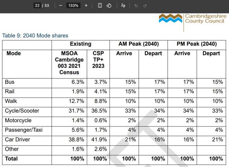
Above – North East Cambridge Transport Position Statement (2025), p22
MSOA = Middle Layer Super Output Area. It’s a term in the Census that relates to a geographical area/unit. The smallest of these is LSOA – Lower Super Output Area, which allows data analysts to get into some of the detail not always apparent in the headline figures. Think of the poverty data in South Cambridge and the micro-pockets of poverty within some council wards such as Queen Edith’s.
The above is the approach the documents take – summary in the main WSP document, and then any links to more detailed papers for each strategic allocation site if needed
Now, moving onto the airport site.
Cambridge East – Cambridge Airport
There’s a glaring omission in this section.
“What’s that?”
- Missing new large concert hall
- Missing new lifelong learning college
- Missing new large city hall for the unitary council
- Missing Cambridge East Station and major public transport interchange and civic square
Above – well that won’t do!
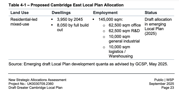
“What do the Vehicular Trip Budgets show for Cambridge East?”
- AM Peak Hour: 1,500 two-way vehicle flows
- A target of 18% and 22% of car trips in the AM and PM peaks respectively for both 2045 and full build out.
Which is ambitious
With such a large mixed-use site proposed for Cambridge East, planners have decided this is an ideal opportunity to build a ’15 minute city [or rather, district within a city]’
“Five-minute neighbourhoods bounded by green corridors to provide a 15- minute city within the site”
What the table in the main WSP document shows are the range of options including their assessment on which ones are essential – without which their model fails.
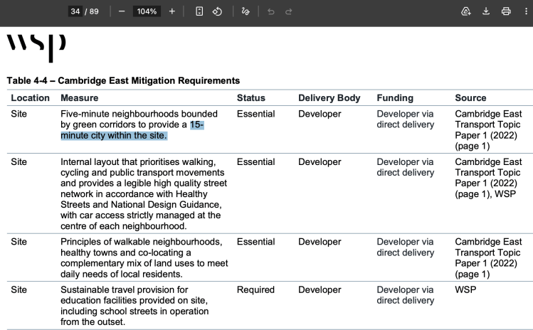
Above WSP (2026) p34 – the developers and planners really have to get this right for Cambridge East given that they have a very large blank piece of land to play with
And now you can hear large groups of lobbyists and developers squealing at the prospect of having to build something to better than the minimum standards – because it hits their profits so they say.
Unfortunately that also means the positives on the last mile delivery systems (something I’ve been calling for, for ages) gets overlooked in all of the noise.
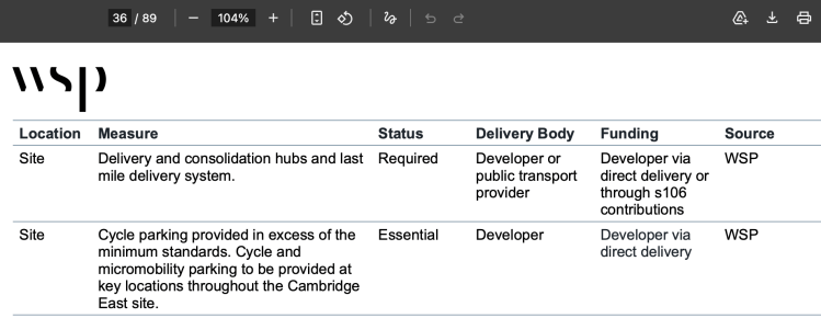
Above WSP (2026) p36 – if planned well, a series of edge-of-city freight exchanges could compel big freight firms to transfer letters and small packets onto small cycle/e-bike couriers for that last mile, with the extra cost absorbed by the sender which, if sending a product in return for payment will ultimately be reflected in higher prices for online shopping while at the same time making the high street that little bit more competitive again.
Set the tariff at the right price and you not only pay the locally-based delivery person, but also potentially have an additional pot-hole fund that’s funded by those who can most afford to pay for it through lots of online shopping. It’s a bit like a tax on celebrity magazines to pay for the upkeep of the royals – with a special draw for participating magazine buyers with the chance for a thousand lucky readers to win tickets to a Royal Garden Party hosted by Prince Edward! What’s there not to like!?!
I jest!
Next, the Cambridge Biomedical Campus
Cambridge Biomedical Campus – the challenges are significant
It all starts from p50 of the WSP document. Of the challenges? There are eighteen of them. Breathe in everyone! This could get messy – because it is a ***monster urban design challenge***
- Fragmented street layout resulting in indirect pedestrian, cycle and bus routes north-south and east-west through the Campus. (Welcome to my neighbourhood!)
- Poor condition of footways, lack of pedestrian crossing priority, poor legibility / wayfinding and presence of street clutter creating barriers to active travel.
- Lack of consistent segregated cycling infrastructure in line with current design guidance for active travel (including the DNA path to the south).
- Poor conditions for pedestrians and cyclists due to private car street dominance at junctions / gateways, particularly Hills Road and at Francis Crick Avenue. Remembering the late Anna Garratt-Quinton Physiotherapist at Addenbrooke’s. Let’s design out these death traps please.
- Poor road safety surrounding the site, with patterns of collisions identified both within the site and surrounding key junctions
- Poor connectivity and coherency with off-site GCP proposals, including the Sawston and Linton Greenways, CSET and Cambridge South West Travel Hub (I shall refrain from commenting on the GCP and CSET)
- Lack of shared transport options, such as car club facilities
- Constrained and operationally challenging Addenbrooke’s bus interchange (in a constituency that between the end of WWII and today has only elected non-Tory MPs twice. (The present Pippa Heylings for LibDems, and Albert Stubbs for Labour). Buses have never been a priority for the Conservatives as their catastrophic deregulation policies of the 1980s and the present bus station at Addenbrooke’s show.
- Congestion on Babraham Road causing delays to bus movements. (Had they listened to us Cambridge Connect Light Rail supporters a decade ago this might have been resolved by now!)
- Lack of existing rail access (See above and also see Rail Future East for the lowdown)
- Blue light routes / emergency vehicle movements need to be considered from the initial design stages to restrict any issues with operation of Addenbrookes hospital. Something that dates from over half a century ago.
- Congestion at key gateways and at peak hours such as Babraham Road and Hills Road. Which reflects the rapid growth without the essential transport infrastructure investment in rail-based transport and active travel to new settlements and re-opened rail lines to nearby towns such as Haverhill
- Issues of speeding and through-traffic within the site, particularly on Dame Mary Archer Way despite being a 20mph route and the use of traffic calming infrastructure. (Which is what happens when central government (historically Conservatives but not always) cut the budgets of police and local government to such a degree that some irresponsible motorists start behaving as if the law no longer exists because it is not being enforced. This has been a longstanding issue for local Liberal Democrat councillors in Cambridge.
- Outside of the existing Addenbrooke’s food court, limited eating and retail opportunities are available across the site to encourage trip internalisation. (Which reflects both poor strategic planning and also a lack of imagination with Cambridge South Station which should have had a civic square built for it with a convenience food shop and independent food outlets in the vicinity.
- Staff travel patterns include shift working, increasing safety concerns for pedestrians and cyclists travelling at night, particularly women’s safety along surrounding unlit routes. (Which comes as little surprise given how few members of staff actually knew about the consultations from the GCP and Combined Authority. How do I know this? When I was in hospital back in December 2021 I asked all the staff that cared for me. The results were shocking (So much so that one of them decided to re-run their consultation!)
- Lack of physical separation between active travel movements and the guided busway (particularly at the bridge over the railway) introduces potential safety concerns between the bridge users – This has now been rectified with metal fencing segregating the too. But it should not have needed the tragic deaths of cyclists and a HSE prosecution to get the fencing installed. They should have been designed in.
- Overspill offsite parking occurs on the uncontrolled surrounding residential streets. And this has been a problem for half a century because local government has so few powers and so little influence over CUH NHS.
- Bus services from Trumpington Park and Ride and Cambridge Station often overloaded at peak times and do not run early and late enough for shift workers.
“So, what are their solutions for Addenbrooke’s, The Rosie, Royal Papworth, and the rest?”
See page 54 onwards of the WSP document
“Anything stand out?”
The lack of any mention of light rail. With a predicted 37,000 jobs, the assessment of what’s needed doesn’t go anywhere near to addressing the scale of the problem when you have members of staff travelling in from Lincolnshire at one end, and Stevenage at the other. (This from my stay in Royal Papworth in 2021). None of the proposals will help those who are so painfully priced out.
“What does it list instead?”
“Implementation of extensive Campus wide public transport improvements that deliver new and upgraded bus routes and provide sufficient capacity to accommodate travel demands, including:
- Package of bus service enhancements connecting the site with Cambridge including
- Newmarket Road Park and Ride,
- Trumpington Park and Ride,
- Southwest Travel Hub,
- Babraham Park and Ride,
- Cambridge Station,
- Cambridge residential areas and
- Madingley Park and Ride.
- Regional bus service improvements from
- Newmarket,
- Royston,
- Cambourne,
- Northstowe,
- Waterbeach and via [Cambridge South East Transport to the A11]
- Employee specific coach / bus services where a need is identified in the vision-led Transport Assessment.
- Extension of bus service start and finish times to match staff shift patterns.
- DRT services.
“What’s DRT?”
‘Demand-Responsive Transport’. See the Government’s explainer here.
The proposals from WSP are far, far too bus-centric to be taken seriously in the face of the huge number of people working on the site, visiting the site or coming in as patients for treatment
Those regional bus services should be suburban or light rail services. Furthermore, that they propose doubling down on buses all the way out to Haverhill is incredulous given the presence of the disused existing railway line.
It wouldn’t surprise me if the Greater Cambridge Development Corporation steps in and pulls rank on this. Not least because we’ve not yet seen what additional housing on top of what’s proposed in the local plan the Minister for Housing and Planning wants to see. Remember in his appointment letter to Peter Freeman of October 2024 he wrote:
“When it comes to the growth strategy, development on a more dispersed geographical footprint is perfectly acceptable, but one or more contiguous urban extensions of [Cambridge] must be core components of the vision the Growth Company brings forward, in order to maximise the benefits of agglomeration. It must also build on and go further than local plans, in terms of scale, ambition and timescale, and you should work closely with local partners to tackle the constraints that can be difficult to overcome at the local level alone.”
Above – Minister for Housing and Planning – Letter to Peter Freeman CBE 31 Oct 2024
I wrote more about this letter and its historical context in this blogpost
In one sense it should not come as a surprise – the statement from the Minister that he wants to see growth beyond what the local plans are proposing. The Cambridge Biomedical Campus’s own housing study prepared for them by Lichfields in Spring 2024 showed that its own demand for housing took up a considerable portion of the proposed new homes in the draft local plan.
“The Cambridge Biomedical Campus will require the building of a settlement larger than Haverhill just to have its own needs met”
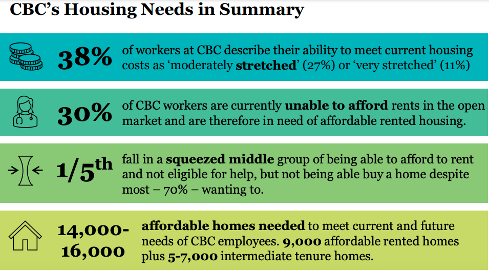
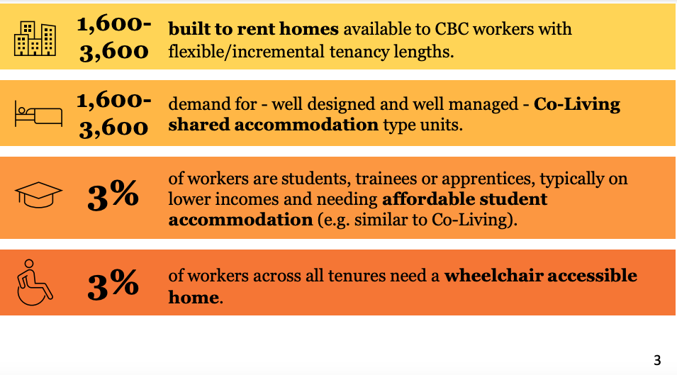
Above – Lichfields (2024) for CBC Ltd, p3
Mindful that I wrote about this just before the general election (see my blogpost from May 2024 here), it’s worth having a refresher of the report in the context of the current political situation and also the presence of the climate emergency in the form of extreme heat and droughts which will have a huge impact on patient services.
What do those transport assessments look like in an era of extreme heat? Of melting roads and restricted speeds on railway lines?
Food for thought?
If you are interested in the longer term future of Cambridge, and on what happens at the local democracy meetings where decisions are made, feel free to:
- Follow me on BSky
- Spot me on LinkedIn
- Like my Facebook page
- Consider a small donation to help fund my continued research and reporting on local democracy in and around Cambridge


