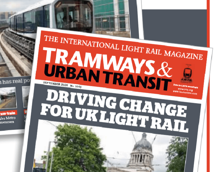
October’s edition of Tramways and Urban Transit Magazine features the Swedish town that was also one of the venues for two of Scotland’s in the long-forgotten Euro ’92
TL/DR? Ignore this post and watch this video of the Norrköping Tram by Rob from Lithuania
“Norrköping? What’s that?”
I first heard about the place as a venue for Euro ’92. And it wasn’t a pleasant tournament for England, and not just because of the results. As former England footballer Carlton Palmer explains here. The press was toxic. Has anything changed?
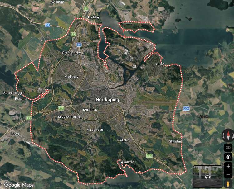
Cambridge vs Norrköping – compare and contrast their urban footprints.
Below: Norrköping from GMaps followed by Cambridge at the same scale:
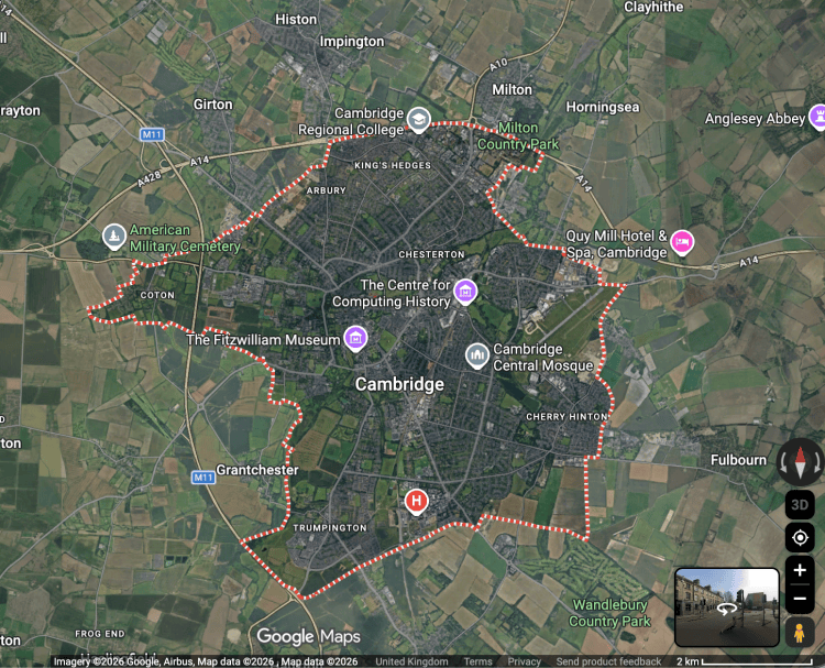
Above – Cambridge from G-Maps broadly to the same scale as Norrköping.
Having already been eliminated by narrow defeats to the defending European Champions The Netherlands, and then to World Cup Winners and recently re-united Germany, Scotland surprised everyone by putting three without reply passed the successor to the Soviet Union, the Commonwealth of Independent States in their final game in Norrköping. One of the reasons I remember it was because it had such a small stadium at the time, only 14,000 or so turning up to watch it in person – albeit at a time when Scandinavia was known to be expensive to UK tourists and also the UK economy was in recession (2.5m unemployed) and would face Black Wednesday three months later.
An historic industrial town and seaport with a central square enclosed by a quartet of public buildings
The internet (or rather WikiP) says (so it must be true) that in the early 20th Century the main square had four temples:
- the Lord’s Temple (Queen Hedwig’s church – named after the German princess who married King Charles the Tenth and who left a notable architectural and artistic legacy),
- the Temple of Justice (ie the town hall with the tall tower),
- the Temple of Mammon (the bank palace) and…
- the Temple of Bacchi (the hotel, ie pleasure)
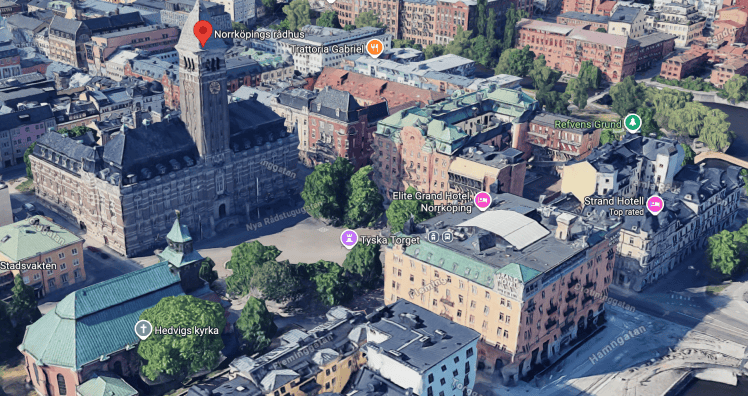
Above – from G-Maps here, Tyska Torget [German Square] in Norrköping with the four public buildings enclosing it. Note the tram tracks at the bottom right which runs over a bridge over the Motala ström (river)
The Norrköping tramways case study
The case study featured in October 2026’s edition of Tramways and Urban Transit Magazine happens to be the venue of the LRTA’s AGM 2026 which started….several hours ago (at the time of posting!)
If the LRTA – founded in 1937 (and was years ahead of its time with its post-war vision of electrified public transport networks) chose it as a host city, then it’s something for the UK’s new Mass Transit Taskforce and the Greater Cambridge Development Corporation along with the CPCA Mayor Paul Bristow and transport staff to pay the town a visit.
Alternatively, the LRTA’s guide on how to plan an efficient tramway makes for a more cost-effective starting point.
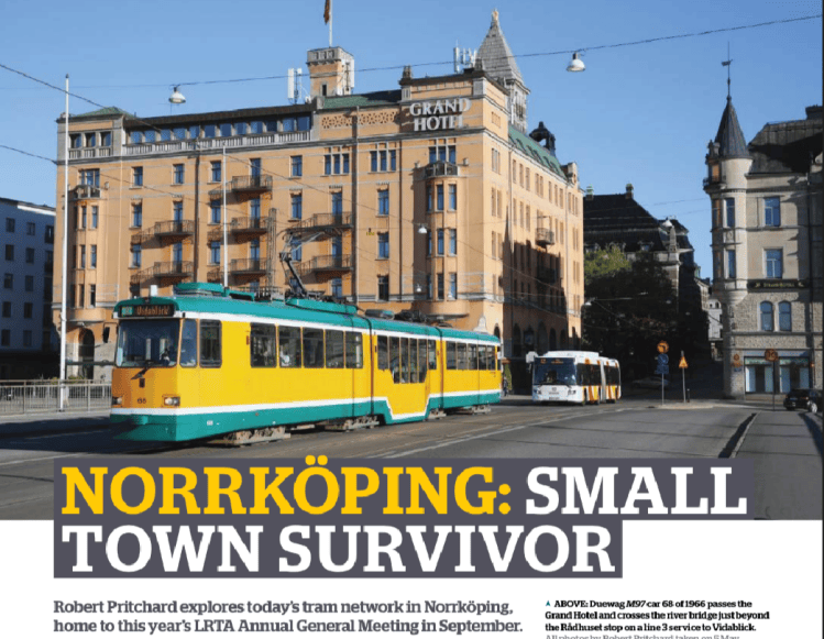
Above – Norrköping: Small Town Survivor (population of the municipality around 143,000 in 2023) in TAUT October 2026 p370
You can get hard copies of the magazine online here and/or get a digital subscription. I’ve now got the latter because the firm that took over what was WHSmiths in Cambridge closed it down and it was the only shop in the city centre that stocked it. Scandalous if you ask me! (Anyone know where in town stocks a large range of magazines these days?)
The old rolling stock still works – but would it be suitable for somewhere like Cambridge with its 10million tourists and high levels of in-commuting?
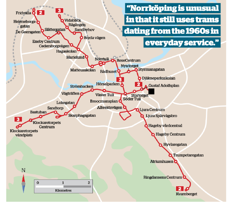
Above – Norrköping tramway plan from in TAUT October 2026 p372
Cautionary note: Building a tramway won’t provide magic wand solutions to motor traffic and other social issues
At the southern edge of the settlement is an intriguing-looking housing development designed and built in the 1960s which has many parallels with what was happening in the UK: i.e. large housing developments to deal with a housing crisis.
The developments that stood out on the map were labelled ‘Ringdansen’, but were originally called Silverringen and Guldringen (Silver Ring and Gold Ring)
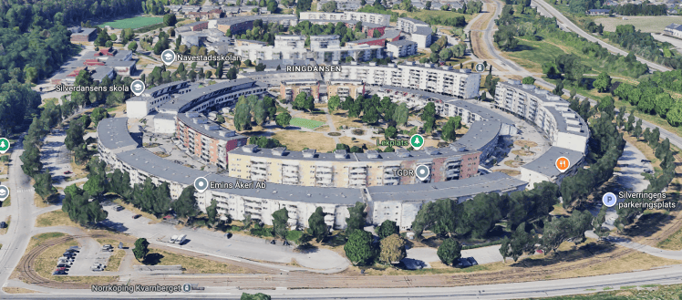
Above – the Ringdansen development on the southern edge of Norrköping. G-Maps here
You can have a look at the historical photographs from the time of construction here
Without having been there, I’m not going to cast big judgements on the place. Instead I’m interested in some of the research into how Sweden has managed housing issues (including immigration and integration) that are similar to the ones the UK faces. What the above image shows is a tramway turning circle in the foreground with the two iconic circular housing developments. The neighbourhood website is here and the piecemeal bits of social history I’ve been able to pick up highlighted the wider socio-political contexts of the 20th century that sound similar to UK cities. i.e. declining traditional manufacturing industries, rising unemployment, and social problems exacerbated by an edge-of-town location that resulted in intervention by the state and the renovation.
Direction of residential housing growth – a similarity to Cambridge’s future?
Recall the instruction from the Minister for Housing Matthew Pennycook MP to Peter Freeman in the appointment letter:
“When it comes to the growth strategy, development on a more dispersed geographical footprint is perfectly acceptable, but one or more contiguous urban extensions of the city must be core components of the vision the Growth Company brings forward, in order to maximise the benefits of agglomeration. It must also build on and go further than local plans, in terms of scale, ambition and timescale, and you should work closely with local partners to tackle the constraints that can be difficult to overcome at the local level alone.”
Which is why this case study of a ‘contiguous urban extension’ **with tramway** and along a post-war transport corridor (now part of the E22 European road/motorway route).
One of the directions of post-war 20th Century housing growth in Norrköping is visible from G-Maps here. This was part of a huge government programme to build 1million homes in a decade – between 1965 and 1974. The lessons from that experience (which Hall and Svejn wrote in 2006 here resulted in a surplus of homes once they approached the 500,000 mark, as well as questions on design and quality – not too dissimilar to the UK’s post-war experiences).
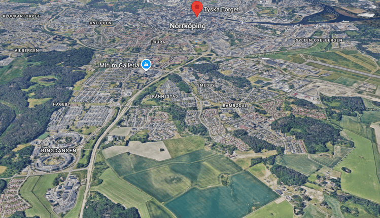
Above – Norrköping on G-Maps here with the German Square/City Hall where the red balloon icon is, and Ringdansen at the bottom-left
If people working on the future of Cambridge were to visit Norrköping, the construction histories and social histories might provide interesting insights that help improve the future plans being developed in the present. Just by looking at the G-Maps images you can see the variety of urban design styles, architectural designs, and building materials used. For example on the other side of the road to some of the 5-6 storey flats at Ringdansen there is an estate of very low density bungalows. What is the story behind putting two very visually different urban designs next to each other? Did it work out the way the architects, urban designers, and politicians anticipated? If not, what were their responses? Move further towards the city centre and the flat-roofed single floor bungalows are preceded by detached houses with pitched roofs over a ground and first floor. Yet in both cases the architectural designs from a distant look almost identical – perhaps similar to American post-war housing estates. And moving further into the city the height of the residential buildings rises again.
Note there is also a significant amount of learning from both what did not work as planned, and the policies that were brought in in response. In this case study, what improvements do residents suggest? Or politicians? Given the chance to start again, what might they do differently?
Minimising risk of creating segregated communities with each round of new development in Cambridge
This was explored by Humanise at the Seoul Biennale in South Korea

Above – you can read the case study on Soft Edges here
“The boundary between farmland and apartment blocks reads as a physical edge between two ways of living. But the distance is social and generational, as well as spatial. Shared space does not necessarily create human connection. Benches, paths, or small public areas can easily be used quite separately. They don’t automatically create togetherness.
“Soft Edges starts from this insight. Rather than relying on space alone, the project explores how to specifically encourage human connection.“
Above – Soft Edges (2025) by Humanise which is part of their pioneering Community Engagement case studies
I’ll save these for a separate blogpost other than to note that with the creation of Eddington as an exclusive Cambridge University enclave that is not on the Stagecoach bus network, the residents of Arbury and King’s Hedges have already been designed out of sharing the benefits. (Have a look at North Cambridge on G-Maps here). Which is also why Cambridge City Council’s Shaping North Cambridge project will be a very important one in the years to come.
And an active unitary council will be vital if Cambridge is to grow successfully. We’ve found out the hard way over the past decade and a half what happens when local government is enfeebled and unable to manage the responsibilities both tasked by the state in terms of statutory duties in law, and also the expectations of the people who make the city what it is – residents, commuters, students alike.
If you are interested in the longer term future of Cambridge, and on what happens at the local democracy meetings where decisions are made, feel free to:
- Follow me on BSky
- Spot me on LinkedIn
- Like my Facebook page
- Consider a small donation to help fund my continued research and reporting on local democracy in and around Cambridge


