Lord Hendy, the Minister of State for Rail approved the controversial application under delegated powers from the Secretary of State for Transport.
Image: The announcement is filed under ‘Rail Infrastructure’ even though it will be a road with road signs saying ‘local buses only’.
You can read the documents here
The recommendation to the Minister came from Planning Inspectors Richard Clegg and Geoff Underwood.
They were the Inspectors who sat through the weeks of public hearings and waded through countless documents and representations before coming to their conclusions.
Note there are *very limited grounds* on which an application to the High Court can be made challenging the issuing of planning permission by ministers. (See the final page of the decision letter on p60 here)
Which is why I’m not going to lose too much sleep now that the final decision has been made. There’s too much going on elsewhere despite being gutted about the decision to go with this rather than a light rail alternative such as that promoted by Dr Colin Harris and colleagues at Connect Cambridge Light Rail.
“What happens to the buses when they get to Grange Road?”
The report doesn’t say. In fact the Inspectors confirm that the busway *does nothing* to improve journey times east of Grange Road.
“We note that the Order Scheme would not do anything to relieve congestion and improve journey times to the east of Grange Road in the City Centre.
Above: C2C Order Report para 20.54, p150
That said, it wasn’t enough to persuade the Inspectors to refuse the application.
“Nevertheless, through the transport benefits, the Scheme should be capable of contributing to a shift in transport mode which is crucial to the Development Plan’s spatial strategy.”
Above: C2C Order Report para 20.54, p150 continued.
The only mention of a wider bus network is in the objection from Cambridge Past, Present, & Future. The problem being that there is no stable long term transport plan that the busway proposals are tied to. The current draft Greater Cambridge Transport Plan that I wrote about here, is the *fourth* ‘long term transport plan’ that applies to Cambridge since 2014. Which is ridiculous.
“The Order Scheme would provide for the construction, maintenance and operation of a guided busway between Cambourne and Cambridge (Figure 1 above). It would extend from Sterling Way on the east side of Cambourne to Grange Road on the west side of Cambridge.”
The growing number of bus vehicles in Cambridge also creates its own congestion issues and road repair/pothole challenges. This is why for the CPCA Transport Committee meeting I tabled a public question asking what assessment the CPCA had made of (amongst other things) commuter bus services (See item 5 here along with 11 other public questions).
The challenge now is how to make the best of a not great decision.
“How many extra buses will be on the streets of Cambridge?”
The Planning Inspectors stated:
“Taking account of existing services, the proposed bus strategy, put forward as part of the outline business case, envisages use of the guided busway in each direction by six services per hour between Cambourne and Cambridge City Centre (including services from and to St Neots and Huntingdon), two services per hour between Cambourne and the Cambridge Biomedical Campus (Biomedical Campus) to the south of the City, and an additional two services per hour during peak periods between the proposed park and ride (P&R) site at Scotland Farm and the Biomedical Campus”
Above C2C Order Report para 5.2, p15
What does six services per hour into Grange Road and the city centre, and six services exiting Grange Road onto the busway look like?
Busy. The question is what routes will the buses follow.
Options:
“Where do buses go at Grange Road?”
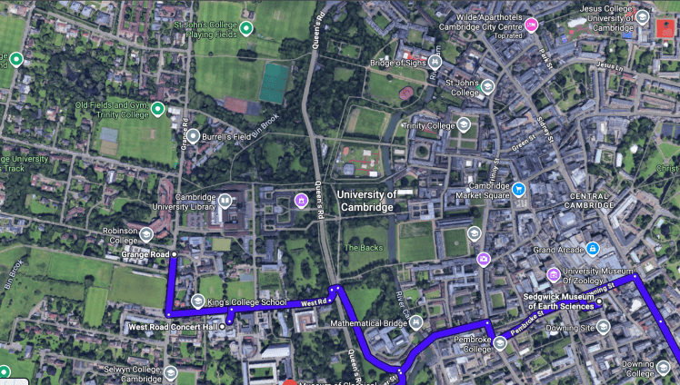
Above – detail from a potential route Grange Road at the Grange Road Stadium where Cambridge United Women’s Football Club are now playing home fixtures, down Queen’s Road, along Silver Street, Pembroke Street and onto Regent Street.
Expect the buses to get ***stuck in lots of motor traffic*** – especially on Saturday mornings when drivers head to Lion Yard. (Wouldn’t have been a problem under my bells-and-whistles light rail plan!)
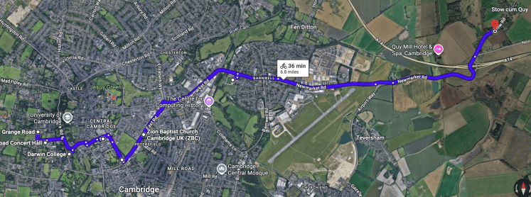
Above – A potential bus route through Cambridge City Centre from Grange Road via Silver Street, East Road and terminating at the proposed Park’n’Ride near Stow which at present is planned for south of the A14, not north as on this illustration on G-Maps
“What if they wanted to turn around at Queen’s Road to avoid getting stuck in city centre traffic?”
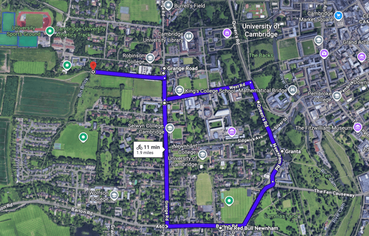
Above – A possible loop route for buses returning to Cambourne – mindful of the proposals to remove motor vehicle access down Sidgwick Avenue. See G-Maps here.
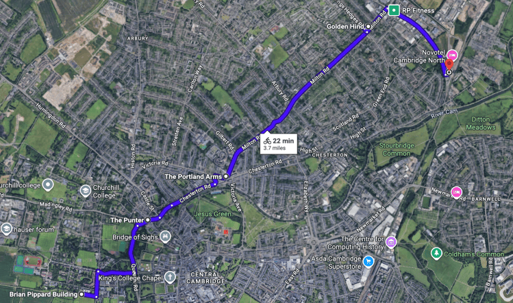
Above – an option terminating at Cambridge North Station, navigating the traffic jams of Chesterton Road, Milton Road, and Grange Road in rush hours. See G-Maps here
Smarter Cambridge Transport’s bus orbital option
His observation was that Drummer Street bus station is too small to act as a terminus, and that treating the inner ring road as a ‘bus hub’ to create a sort of London bus network effect where multiple services stop at the same stop to enable quick and easy interchanges. Next time you head to London King’s Cross, have a look at the bus stops on Euston Road and see where the buses come from and go to. It should look like a less complicated version of that!
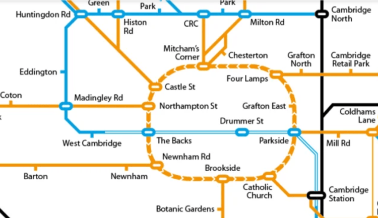
Above – Smarter Cambridge Transport’s proposed bus orbital and hub, 11 September 2018
Mass Rapid Transit progress
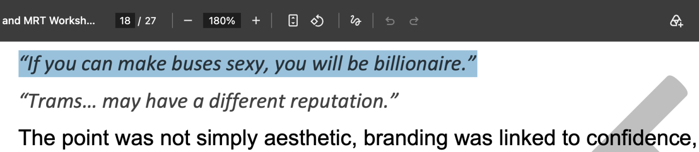
I covered this in my earlier blogpost here where one person asked about ‘making buses sexy’. Now, I like to purchase a copy of Buses Magazine as and when I can, but I can’t recall *any article* asking about how to make buses sexy.
My guess is that we’ll find out more about mass rapid transit schemes following the Budget which is due at the end of October.
The City Access Program remains outstanding.
I quoted the GCP’s Independent Audit in this post from June 2021
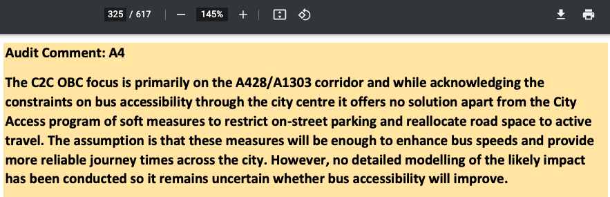
“[The Cambourne to Cambridge Busway Project] …offers no solution apart from the City Access program of soft measures to restrict on-street parking and reallocate road space to active travel. The assumption is that these measures will be enough to enhance bus speeds and provide more reliable journey times across the city. However, no detailed modelling of the likely impact has been conducted so it remains uncertain whether bus accessibility will improve.”Agenda Pack for Greater Cambridge Assembly, 20 June 2021 – p 325.
You can read the full independent audit from p306 of the Agenda Pack
This is an issue that Sarah Hughes has tabled for the CPCA Transport Committee Meeting which will have finished by the time most of you have read this. It reads as follows:
“”The Greater Cambridge Local Plan’s Transport Evidence Report suggests that the additional growth already planned in places such as Northstowe, Bourn Airfield and Waterbeach New Town (without adding the 2026 Local Plan’s growth) will increase journey time delay on the road network in Greater Cambridge by between 41% in the AM peak and 61% in the PM peak in 2041 over the 2015 baseline (figure 30). This is the predicted delay when this growth is mitigated by schemes the modelling assumed would be in place by 2041, including City Access (the GCP’s flagship City Access scheme was the Cambridge Sustainable Travel Zone road charge, which fell away in 2023). The 2026 Local Plan’s growth will increase this delay yet further.
The Transport Evidence Report goes on to say that the Local Plan ‘works’ in transport terms if there is a strategic connectivity solution for Cambridge (as described on p13 of the Greater Cambridge Transport Strategy; our emphasis). Specifically, the Transport Evidence Report states: “there is nothing in the modelling results to suggest that the development locations and quantum included in the Emerging Preferred Development Strategy for Draft Plan cannot be accommodated on the transport network providing mitigation commensurate with the city access proxy within the model runs is delivered” (Transport Evidence Report Part 4, p 43).
“The cornerstone of the GCP’s City Access scheme was a scheme that simultaneously generated an annual income of around £50 million a year to support a transformed bus network into the future and reduced motor traffic in Cambridge – the Cambridge Sustainable Travel Zone road charge.
“The draft Greater Cambridge Transport Strategy rules out road charging, so what is the strategic connectivity solution for Cambridge commensurate with City Access that it proposes?””
It will be interesting to see what the response is.
If you are interested in the longer term future of Cambridge, and on what happens at the local democracy meetings where decisions are made, feel free to:
- Follow me on BSky
- Spot me on LinkedIn
- Like my Facebook page
- Consider a small donation to help fund my continued research and reporting on local democracy in and around Cambridge


